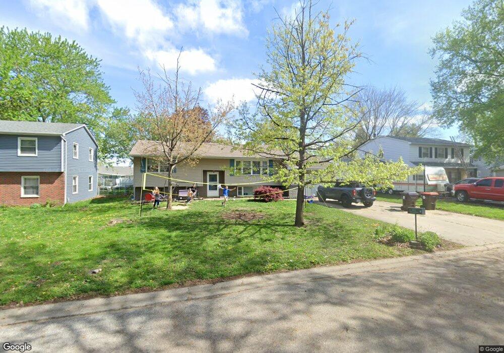
220 Rhoads Ave Lincoln, IL 62656
Estimated Value: $147,000 - $168,000
Studio
--
Bath
1,080
Sq Ft
$146/Sq Ft
Est. Value
About This Home
This home is located at 220 Rhoads Ave, Lincoln, IL 62656 and is currently estimated at $158,153, approximately $146 per square foot. 220 Rhoads Ave is a home located in Logan County with nearby schools including Adams Elementary School, Central Elementary School, and Lincoln Junior High School.
Ownership History
Date
Name
Owned For
Owner Type
Purchase Details
Closed on
Jan 6, 2022
Sold by
Mcintosh Michael Dale and Mcintosh Penny M
Bought by
Vanwie James Alllen and Vanwie Van Wie
Current Estimated Value
Purchase Details
Closed on
Sep 23, 1991
Bought by
Mcintosh Michael D and Mcintosh Penny M
Create a Home Valuation Report for This Property
The Home Valuation Report is an in-depth analysis detailing your home's value as well as a comparison with similar homes in the area
Home Values in the Area
Average Home Value in this Area
Purchase History
| Date | Buyer | Sale Price | Title Company |
|---|---|---|---|
| Vanwie James Alllen | $110,000 | None Available | |
| Mcintosh Michael D | $76,000 | -- |
Source: Public Records
Tax History
| Year | Tax Paid | Tax Assessment Tax Assessment Total Assessment is a certain percentage of the fair market value that is determined by local assessors to be the total taxable value of land and additions on the property. | Land | Improvement |
|---|---|---|---|---|
| 2024 | $3,662 | $45,940 | $8,370 | $37,570 |
| 2023 | $3,456 | $42,540 | $7,750 | $34,790 |
| 2022 | $3,923 | $39,750 | $7,240 | $32,510 |
| 2021 | $3,778 | $38,160 | $6,950 | $31,210 |
| 2020 | $3,730 | $37,600 | $6,850 | $30,750 |
| 2019 | $3,652 | $36,870 | $6,720 | $30,150 |
| 2018 | $3,624 | $36,150 | $6,590 | $29,560 |
| 2017 | $3,603 | $36,150 | $6,590 | $29,560 |
| 2016 | $3,510 | $36,110 | $6,580 | $29,530 |
| 2015 | $3,781 | $38,670 | $6,360 | $32,310 |
| 2014 | $3,781 | $38,670 | $6,360 | $32,310 |
| 2013 | $3,781 | $36,710 | $6,040 | $30,670 |
| 2012 | $3,781 | $37,370 | $6,150 | $31,220 |
Source: Public Records
Map
Nearby Homes
- 1708 Rutledge Dr
- 1208 N Kankakee St
- 180 Regent St
- 1412 N Union St
- 816 N Logan St
- 628 Grand Ave
- 130 Half Moon St
- 515 Oglesby Ave
- 1779 1250th Ave
- 417 N Union St
- 620 Tremont St
- 906 Peoria St
- 215 Park Place
- 325 Mcdivitt Ave
- 355 Mcdivitt Ave
- 2294 Railsplitter Ave
- 2344 Railsplitter Ave
- 204 9th St
- 113 N Kickapoo St
- 701 21st St
- 224 Rhoads Ave
- 216 Rhoads Ave
- 210 Rhoads Ave
- 1314 Feldman Dr
- 1312 Feldman Dr
- 300 Rhoads Ave
- 1316 Feldman Dr
- 219 Rhoads Ave
- 225 Rhoads Ave
- 215 Rhoads Ave
- 1308 Feldman Dr
- 5 Ophir Ave
- 1340 Richland Ave
- 211 Rhoads Ave
- 1318 Feldman Dr
- 305 Rhoads Ave
- 1350 Richland Ave
- 1320 Feldman Dr
- 1322 Richland Ave
- 15 Ophir Ave
Your Personal Tour Guide
Ask me questions while you tour the home.