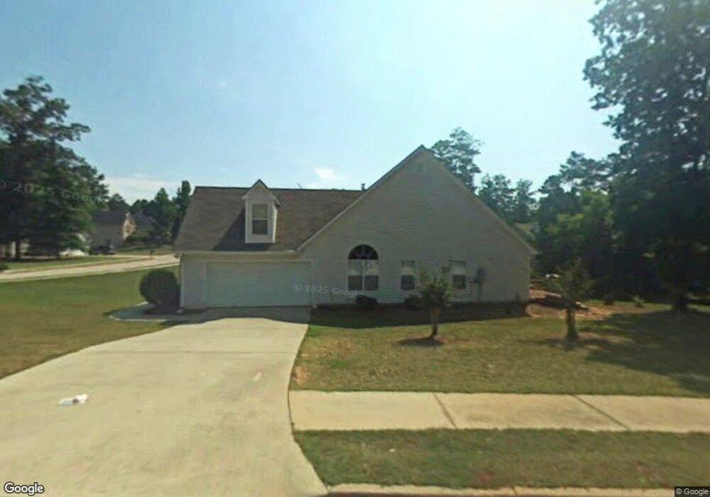
220 Rockport Dr McDonough, GA 30253
Estimated Value: $321,000 - $335,921
3
Beds
2
Baths
2,104
Sq Ft
$156/Sq Ft
Est. Value
About This Home
This home is located at 220 Rockport Dr, McDonough, GA 30253 and is currently estimated at $328,730, approximately $156 per square foot. 220 Rockport Dr is a home located in Henry County with nearby schools including Union Grove Middle School, Union Grove High School, and Hickory Flat Elementary School.
Ownership History
Date
Name
Owned For
Owner Type
Purchase Details
Closed on
May 30, 2019
Sold by
Hardegree James B
Bought by
Tucker Wanda
Current Estimated Value
Home Financials for this Owner
Home Financials are based on the most recent Mortgage that was taken out on this home.
Original Mortgage
$189,900
Outstanding Balance
$166,621
Interest Rate
4.1%
Estimated Equity
$162,109
Purchase Details
Closed on
Aug 11, 2006
Sold by
Hardegree James B
Bought by
Hardegree James B and Hardegree Jill J
Home Financials for this Owner
Home Financials are based on the most recent Mortgage that was taken out on this home.
Original Mortgage
$140,000
Interest Rate
6.39%
Mortgage Type
New Conventional
Purchase Details
Closed on
Jun 6, 1999
Sold by
Mnw Construction Co
Bought by
Mccrakin Joe G and Mccrakin Cynthia G
Home Financials for this Owner
Home Financials are based on the most recent Mortgage that was taken out on this home.
Original Mortgage
$142,550
Interest Rate
7.23%
Mortgage Type
FHA
Create a Home Valuation Report for This Property
The Home Valuation Report is an in-depth analysis detailing your home's value as well as a comparison with similar homes in the area
Home Values in the Area
Average Home Value in this Area
Purchase History
| Date | Buyer | Sale Price | Title Company |
|---|---|---|---|
| Tucker Wanda | $189,900 | -- | |
| Hardegree James B | -- | -- | |
| Hardegree James B | $186,000 | -- | |
| Mccrakin Joe G | $144,500 | -- |
Source: Public Records
Mortgage History
| Date | Status | Borrower | Loan Amount |
|---|---|---|---|
| Open | Tucker Wanda | $189,900 | |
| Previous Owner | Hardegree James B | $140,000 | |
| Previous Owner | Mccrakin Joe G | $142,550 |
Source: Public Records
Tax History Compared to Growth
Tax History
| Year | Tax Paid | Tax Assessment Tax Assessment Total Assessment is a certain percentage of the fair market value that is determined by local assessors to be the total taxable value of land and additions on the property. | Land | Improvement |
|---|---|---|---|---|
| 2025 | $417 | $137,400 | $16,000 | $121,400 |
| 2024 | $417 | $129,640 | $16,000 | $113,640 |
| 2023 | $173 | $129,240 | $14,000 | $115,240 |
| 2022 | $78 | $98,520 | $14,000 | $84,520 |
| 2021 | $3,320 | $84,520 | $14,000 | $70,520 |
| 2020 | $2,992 | $75,960 | $11,850 | $64,110 |
| 2019 | $2,492 | $70,920 | $10,000 | $60,920 |
| 2018 | $2,380 | $67,080 | $10,000 | $57,080 |
| 2016 | $2,068 | $58,960 | $8,000 | $50,960 |
| 2015 | $1,999 | $55,880 | $8,000 | $47,880 |
| 2014 | $2,063 | $56,960 | $8,000 | $48,960 |
Source: Public Records
Map
Nearby Homes
- 1401 Aberdeen Ct
- 212 Himalaya Way
- 248 Cranapple Ln
- 146 Himalaya Way
- 312 Wichita Way
- 401 Crosshaven Way
- 733 Stonehaven Chase
- 1102 Strath Clyde Way
- 153 Rockport Dr
- 941 Arbor Way
- 1181 Paramount Dr
- 176 Cranapple Ln
- 337 Inverness Ave
- 273 Summit View Dr
- 479 Sawtooth Ln
- 441 Aviemore Loop
- 271 Mckinley Loop
- 0 E Lake Pkwy Unit 9004730
- 1012 Brannan Rd
- 113 Glenmore Ln
- 1400 Aberdeen Ct
- 212 Rockport Dr
- 221 Rockport Dr
- 1404 Aberdeen Ct
- 1028 Arbor Way
- 0 Aberdeen Ct
- 230 Rockport Dr
- 1016 Arbor Way
- 225 Rockport Dr
- 1032 Arbor Way
- 229 Rockport Dr
- 1410 Aberdeen Ct
- 206 Rockport Dr
- 1015 Arbor Way
- 503 Newcastle Terrace
- 205 Rockport Dr
- 1409 Aberdeen Ct
- 1036 Arbor Way
- 504 Newcastle Terrace
- 1405 Aberdeen Ct