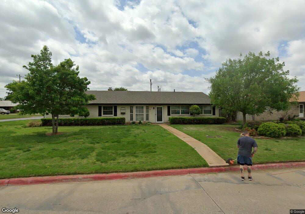
2202 W Randall Ave Duncan, OK 73533
Estimated Value: $239,000 - $255,610
4
Beds
3
Baths
2,400
Sq Ft
$103/Sq Ft
Est. Value
About This Home
This home is located at 2202 W Randall Ave, Duncan, OK 73533 and is currently estimated at $247,653, approximately $103 per square foot. 2202 W Randall Ave is a home located in Stephens County with nearby schools including Horace Mann Elementary School, Duncan Middle School, and Duncan High School.
Ownership History
Date
Name
Owned For
Owner Type
Purchase Details
Closed on
Mar 7, 2022
Sold by
Don Cope Billy and Don Brenda
Bought by
Janson John E and Janson Ashleigh K
Current Estimated Value
Home Financials for this Owner
Home Financials are based on the most recent Mortgage that was taken out on this home.
Original Mortgage
$201,286
Outstanding Balance
$187,729
Interest Rate
3.92%
Mortgage Type
FHA
Estimated Equity
$59,924
Create a Home Valuation Report for This Property
The Home Valuation Report is an in-depth analysis detailing your home's value as well as a comparison with similar homes in the area
Home Values in the Area
Average Home Value in this Area
Purchase History
| Date | Buyer | Sale Price | Title Company |
|---|---|---|---|
| Janson John E | $205,000 | Old Republic Title |
Source: Public Records
Mortgage History
| Date | Status | Borrower | Loan Amount |
|---|---|---|---|
| Open | Janson John E | $201,286 |
Source: Public Records
Tax History Compared to Growth
Tax History
| Year | Tax Paid | Tax Assessment Tax Assessment Total Assessment is a certain percentage of the fair market value that is determined by local assessors to be the total taxable value of land and additions on the property. | Land | Improvement |
|---|---|---|---|---|
| 2025 | $2,043 | $24,216 | $1,291 | $22,925 |
| 2024 | $2,043 | $23,983 | $1,291 | $22,692 |
| 2023 | $2,043 | $22,841 | $1,291 | $21,550 |
| 2022 | $1,276 | $23,071 | $1,291 | $21,780 |
| 2021 | $1,168 | $14,718 | $1,291 | $13,427 |
| 2020 | $1,112 | $13,874 | $1,291 | $12,583 |
| 2019 | $1,079 | $13,470 | $1,291 | $12,179 |
| 2018 | $1,076 | $13,077 | $1,291 | $11,786 |
| 2017 | $1,035 | $13,432 | $1,214 | $12,218 |
| 2016 | $991 | $12,661 | $1,116 | $11,545 |
| 2015 | $897 | $12,293 | $1,058 | $11,235 |
| 2014 | $897 | $11,934 | $1,000 | $10,934 |
Source: Public Records
Map
Nearby Homes
- 1929 W Chisholm Dr
- 2110 W Amhurst Ave
- 2204 W Parkview Ave
- 2206 2206 W Spruce
- 1212 1212 N 21st
- 2230 W Spruce St
- 1302 N 21st St
- 1902 W Randall Ave
- 1099 N 19th St
- 1311 1311 N 20 St
- 1807 W Chisholm Dr
- 2210 Western Dr
- 507 N Alice Dr
- 2202 W Canary Ave
- 2120 2120 Flamingo Ln
- 812 N 15th St
- 815 N 14th St
- 210 N 22nd St
- 209 N 22nd St
- 1244 Carriage Dr
- 2202 W Randall Ave
- 2204 W Randall Ave
- 1101 N Whisenant Dr
- 2203 W Chisholm Dr
- 2206 W Randall Ave
- 1104 N Whisenant Dr
- 2205 W Chisholm Dr
- 2205 W Chisholm Dr
- 2205 W Chisholm Dr
- 1102 N Whisenant Dr
- 2208 W Randall Ave
- 2117 W Randall Ave
- 2118 W Randall Ave
- 2207 W Chisholm Dr
- 1008 N Whisenant Dr
- 2115 W Randall Ave
- 2116 W Randall Ave
- 1931 W Chisholm Dr
- 2202 W Chisholm Dr
- 2210 W Randall Ave