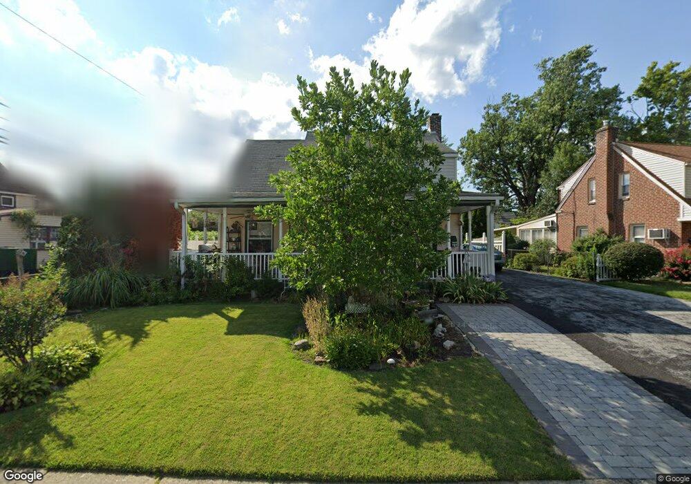
2203 Locust Rd Morton, PA 19070
Estimated Value: $384,000 - $436,000
3
Beds
2
Baths
1,999
Sq Ft
$205/Sq Ft
Est. Value
About This Home
This home is located at 2203 Locust Rd, Morton, PA 19070 and is currently estimated at $409,956, approximately $205 per square foot. 2203 Locust Rd is a home located in Delaware County with nearby schools including Amosland El School, Ridley Middle School, and Ridley High School.
Ownership History
Date
Name
Owned For
Owner Type
Purchase Details
Closed on
Aug 26, 2017
Sold by
Hollenden Charles J and Hollenden Rita
Bought by
Hollenden Charles J and Hollenden Rita
Current Estimated Value
Home Financials for this Owner
Home Financials are based on the most recent Mortgage that was taken out on this home.
Original Mortgage
$184,200
Outstanding Balance
$127,330
Interest Rate
3.96%
Mortgage Type
New Conventional
Estimated Equity
$282,626
Purchase Details
Closed on
Aug 9, 1988
Sold by
Connor John E
Bought by
Hollenden Charles J and Hollenden Rita
Create a Home Valuation Report for This Property
The Home Valuation Report is an in-depth analysis detailing your home's value as well as a comparison with similar homes in the area
Home Values in the Area
Average Home Value in this Area
Purchase History
| Date | Buyer | Sale Price | Title Company |
|---|---|---|---|
| Hollenden Charles J | -- | None Available | |
| Hollenden Charles J | $122,000 | -- |
Source: Public Records
Mortgage History
| Date | Status | Borrower | Loan Amount |
|---|---|---|---|
| Open | Hollenden Charles J | $184,200 |
Source: Public Records
Tax History Compared to Growth
Tax History
| Year | Tax Paid | Tax Assessment Tax Assessment Total Assessment is a certain percentage of the fair market value that is determined by local assessors to be the total taxable value of land and additions on the property. | Land | Improvement |
|---|---|---|---|---|
| 2025 | $7,104 | $204,610 | $66,990 | $137,620 |
| 2024 | $7,104 | $204,610 | $66,990 | $137,620 |
| 2023 | $6,795 | $204,610 | $66,990 | $137,620 |
| 2022 | $6,577 | $204,610 | $66,990 | $137,620 |
| 2021 | $10,182 | $204,610 | $66,990 | $137,620 |
| 2020 | $6,607 | $116,950 | $34,130 | $82,820 |
| 2019 | $6,486 | $116,950 | $34,130 | $82,820 |
| 2018 | $6,405 | $116,950 | $0 | $0 |
| 2017 | $6,405 | $116,950 | $0 | $0 |
| 2016 | $642 | $116,950 | $0 | $0 |
| 2015 | $642 | $116,950 | $0 | $0 |
| 2014 | $642 | $116,950 | $0 | $0 |
Source: Public Records
Map
Nearby Homes
- 357 Cedar Ave
- 363 Holmes Rd
- 339 Sutton Ave
- 668 Hutchinson Terrace
- 209 Amosland Rd
- 742 Agnes Ave
- 211 Cedar Ave
- 614 Highland Terrace
- 810 Quince Ln
- 216-218 President Ave
- 136 Linden Ave
- 1828 5th Ave
- 2330 Poe Rd
- 1646 Norwood Ave
- 916 Brooke Ave
- 1618 Pennsylvania Ave
- 618 W South Ave
- 225 Swarthmore Ave
- 409 Urban Ave
- 115 President Ave
- 2207 Locust Rd
- 542 Stanbridge Rd
- 546 Stanbridge Rd
- 2211 Locust Rd
- 550 Stanbridge Rd
- 567 Holmes Rd
- 563 Holmes Rd
- 532 Stanbridge Rd
- 2204 Locust Rd
- 2208 Locust Rd
- 2212 Locust Rd
- 2215 Locust Rd
- 554 Stanbridge Rd
- 559 Holmes Rd
- 507 Stanbridge Rd
- 2216 Locust Rd
- 547 Stanbridge Rd
- 543 Stanbridge Rd
- 528 Stanbridge Rd
- 551 Stanbridge Rd