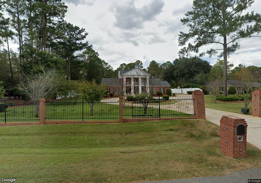
2203 Trowbridge Rd Albany, GA 31721
Estimated Value: $330,493 - $440,000
4
Beds
3
Baths
3,379
Sq Ft
$106/Sq Ft
Est. Value
About This Home
This home is located at 2203 Trowbridge Rd, Albany, GA 31721 and is currently estimated at $358,873, approximately $106 per square foot. 2203 Trowbridge Rd is a home located in Dougherty County with nearby schools including Lake Park Elementary School, Merry Acres Middle School, and Westover High School.
Ownership History
Date
Name
Owned For
Owner Type
Purchase Details
Closed on
Sep 10, 2025
Sold by
Joan Carole Northrop Revocable Trust
Bought by
Northrop Edward D
Current Estimated Value
Purchase Details
Closed on
Nov 7, 2023
Sold by
Northrop Joan C
Bought by
Joan Carole Northrop Revocable Trust and Northrop Joan Carole Trust
Purchase Details
Closed on
Feb 17, 1997
Sold by
Northrop Edward D
Bought by
Northrop Joan C
Purchase Details
Closed on
Jan 1, 1988
Sold by
Hunter Jean E
Bought by
Northrop Edward D and Northrop Joan C
Create a Home Valuation Report for This Property
The Home Valuation Report is an in-depth analysis detailing your home's value as well as a comparison with similar homes in the area
Home Values in the Area
Average Home Value in this Area
Purchase History
| Date | Buyer | Sale Price | Title Company |
|---|---|---|---|
| Northrop Edward D | -- | -- | |
| Northrop Edward D Jr Rev Trust | -- | -- | |
| Joan Carole Northrop Revocable Trust | -- | -- | |
| Northrop Joan C | -- | -- | |
| Northrop Edward D | $190,000 | -- |
Source: Public Records
Tax History Compared to Growth
Tax History
| Year | Tax Paid | Tax Assessment Tax Assessment Total Assessment is a certain percentage of the fair market value that is determined by local assessors to be the total taxable value of land and additions on the property. | Land | Improvement |
|---|---|---|---|---|
| 2024 | $4,481 | $93,928 | $14,000 | $79,928 |
| 2023 | $4,376 | $93,928 | $14,000 | $79,928 |
| 2022 | $4,392 | $93,928 | $14,000 | $79,928 |
| 2021 | $4,072 | $93,928 | $14,000 | $79,928 |
| 2020 | $4,082 | $93,928 | $14,000 | $79,928 |
| 2019 | $4,097 | $93,928 | $14,000 | $79,928 |
| 2018 | $0 | $93,928 | $14,000 | $79,928 |
| 2017 | $3,833 | $93,928 | $14,000 | $79,928 |
| 2016 | $3,835 | $93,928 | $14,000 | $79,928 |
| 2015 | $3,846 | $93,928 | $14,000 | $79,928 |
| 2014 | $3,797 | $93,928 | $14,000 | $79,928 |
Source: Public Records
Map
Nearby Homes
- 2202 Trowbridge Rd
- 2107 Cumberland Ln
- 2115 Cumberland Ln
- 2207 Vineyard Ct
- 2212 Arrowwood Dr
- 3114 Westgate Dr
- 2303 Saddlebrook Ct
- 1903 Devon Dr
- 3422 Plantation Dr
- 3013 Ember Ct
- 3203 Wexford Dr
- 3424 Bellingham Ln
- 2813 Capers Ln
- 2511 Wexford Dr
- 1800 Regalwood Dr
- 3101 Old Dawson Rd
- 1720 Whisperwood St
- 2303 Pineridge Ln
- 1506 Westwood Dr
- 2421 E Alberson Dr
- 2201 Trowbridge Rd
- 2200 Devon Dr
- 2202 Devon Dr
- 2204 Trowbridge Rd
- 2206 Trowbridge Rd
- 2200 Trowbridge Rd
- 3102 Devon Dr
- 2204 Devon Dr
- 2201 Devon Dr
- 2208 Trowbridge Rd
- 2111 Cumberland Ln
- 2203 Devon Dr
- 2109 Cumberland Ln
- 2113 Cumberland Ln
- 2107 Devon Dr
- 2100 Devon Dr
- 2205 Devon Dr
- 2105 Cumberland Ln
- 2115&211 Cumberland Ln
- 2105 Devon Dr