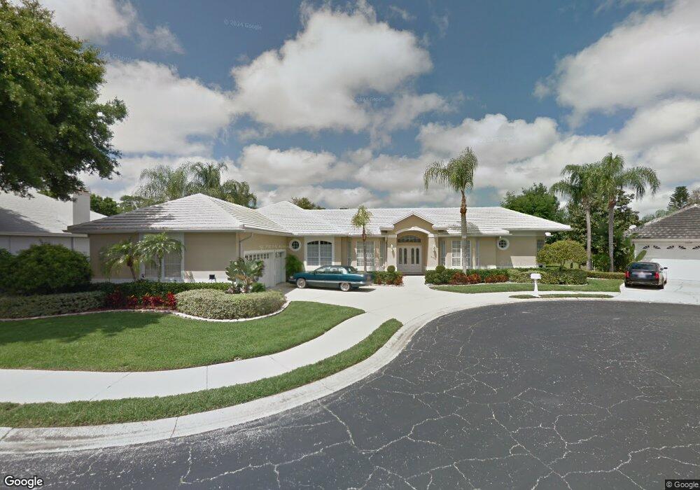
2206 Hampstead Ct Safety Harbor, FL 34695
Estimated Value: $805,385 - $983,000
--
Bed
1
Bath
2,954
Sq Ft
$310/Sq Ft
Est. Value
About This Home
This home is located at 2206 Hampstead Ct, Safety Harbor, FL 34695 and is currently estimated at $915,096, approximately $309 per square foot. 2206 Hampstead Ct is a home located in Pinellas County with nearby schools including Safety Harbor Elementary School, Countryside High School, and Safety Harbor Middle School.
Ownership History
Date
Name
Owned For
Owner Type
Purchase Details
Closed on
Apr 28, 2005
Sold by
Moyle Kathleen E
Bought by
Moyle Kathleen E and Moyle Elizabeth Susan
Current Estimated Value
Purchase Details
Closed on
May 28, 1998
Sold by
Laplaunt Timothy L and Laplaunt Mary L
Bought by
Moyle James W and Moyle Kathleen E
Home Financials for this Owner
Home Financials are based on the most recent Mortgage that was taken out on this home.
Original Mortgage
$200,000
Interest Rate
7.11%
Mortgage Type
New Conventional
Purchase Details
Closed on
Aug 18, 1993
Sold by
Fl Silad Inv Inc
Bought by
Laplaunt Timothy L and Laplaunt Mary L
Home Financials for this Owner
Home Financials are based on the most recent Mortgage that was taken out on this home.
Original Mortgage
$189,600
Interest Rate
7.22%
Create a Home Valuation Report for This Property
The Home Valuation Report is an in-depth analysis detailing your home's value as well as a comparison with similar homes in the area
Home Values in the Area
Average Home Value in this Area
Purchase History
| Date | Buyer | Sale Price | Title Company |
|---|---|---|---|
| Moyle Kathleen E | -- | -- | |
| Moyle James W | $250,000 | -- | |
| Laplaunt Timothy L | $237,000 | -- |
Source: Public Records
Mortgage History
| Date | Status | Borrower | Loan Amount |
|---|---|---|---|
| Previous Owner | Laplaunt Timothy L | $200,000 | |
| Previous Owner | Laplaunt Timothy L | $189,600 |
Source: Public Records
Tax History Compared to Growth
Tax History
| Year | Tax Paid | Tax Assessment Tax Assessment Total Assessment is a certain percentage of the fair market value that is determined by local assessors to be the total taxable value of land and additions on the property. | Land | Improvement |
|---|---|---|---|---|
| 2024 | $5,078 | $344,319 | -- | -- |
| 2023 | $5,078 | $334,290 | $0 | $0 |
| 2022 | $4,942 | $324,553 | $0 | $0 |
| 2021 | $5,014 | $315,100 | $0 | $0 |
| 2020 | $5,006 | $310,750 | $0 | $0 |
| 2019 | $4,923 | $303,763 | $0 | $0 |
| 2018 | $4,850 | $298,099 | $0 | $0 |
| 2017 | $4,814 | $291,968 | $0 | $0 |
| 2016 | $4,778 | $285,963 | $0 | $0 |
| 2015 | $4,879 | $283,975 | $0 | $0 |
| 2014 | $4,856 | $281,721 | $0 | $0 |
Source: Public Records
Map
Nearby Homes
- 2208 Hampstead Ct
- 2225 Windsong Ct
- 1111 Chatham Ct
- 1009 Wyndham Way
- 1005 Chatham Ct
- 1119 Huntington Ln
- 3321 Meander Ln
- 137 Woodcreek Dr E
- 910 Kingscote Ct
- 110 Woodcreek Dr S
- 720 Earls Ct
- 167 Woodcreek Dr W
- 1205 Hounds Run
- 647 Fairmont Ave Unit C
- 605 Quail Keep Dr
- 3 Booth Blvd
- 2356 Messenger Cir
- 3084 Marlo Blvd
- 511 Haverhill Ln
- 2363 Flanders Way Unit C
- 1605 Governors Ln
- 2207 Ramsgate Ct
- 2209 Ramsgate Ct
- 2209 Hampstead Ct
- 2205 Ramsgate Ct
- 2207 Hampstead Ct
- 2211 Hampstead Ct
- 1602 Governors Ln
- 1604 Governors Ln
- 2211 Ramsgate Ct
- 1604 Huntington Ln
- 2205 Hampstead Ct
- 1602 Huntington Ln
- 1606 Governors Ln
- 1606 Huntington Ln
- 1600 Huntington Ln
- 2206 Ramsgate Ct
- 2208 Ramsgate Ct
- 1608 Huntington Ln
- 2210 Ramsgate Ct