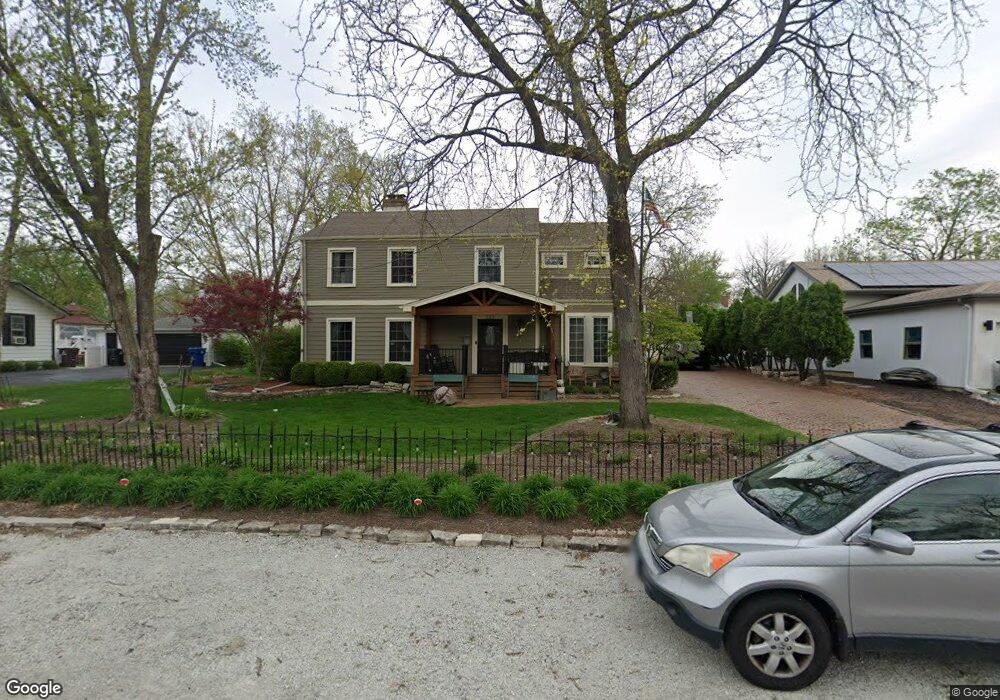
221 Ash St New Lenox, IL 60451
Estimated Value: $377,000 - $424,717
3
Beds
3
Baths
--
Sq Ft
7,841
Sq Ft Lot
About This Home
This home is located at 221 Ash St, New Lenox, IL 60451 and is currently estimated at $403,679. 221 Ash St is a home located in Will County with nearby schools including Oster-Oakview School, Haines Elementary School, and Lincoln Way West.
Ownership History
Date
Name
Owned For
Owner Type
Purchase Details
Closed on
Nov 10, 2009
Sold by
Strand Paul and Strand Connie
Bought by
Marquette Bank and Trust #19123
Current Estimated Value
Purchase Details
Closed on
Jun 7, 2002
Sold by
Rizzi Brett and Rizzi Linda J
Bought by
Rizzi Linda J and The Linda J Rizzi Revocable Tr
Purchase Details
Closed on
Jun 18, 1999
Sold by
Conway Kieran
Bought by
Rizzi Brett and Rizzi Linda J
Home Financials for this Owner
Home Financials are based on the most recent Mortgage that was taken out on this home.
Original Mortgage
$165,000
Interest Rate
7.25%
Mortgage Type
Purchase Money Mortgage
Create a Home Valuation Report for This Property
The Home Valuation Report is an in-depth analysis detailing your home's value as well as a comparison with similar homes in the area
Home Values in the Area
Average Home Value in this Area
Purchase History
| Date | Buyer | Sale Price | Title Company |
|---|---|---|---|
| Marquette Bank | -- | None Available | |
| Rizzi Linda J | -- | -- | |
| Rizzi Brett | -- | -- | |
| Rizzi Brett | $220,000 | -- |
Source: Public Records
Mortgage History
| Date | Status | Borrower | Loan Amount |
|---|---|---|---|
| Previous Owner | Rizzi Brett | $165,000 |
Source: Public Records
Tax History Compared to Growth
Tax History
| Year | Tax Paid | Tax Assessment Tax Assessment Total Assessment is a certain percentage of the fair market value that is determined by local assessors to be the total taxable value of land and additions on the property. | Land | Improvement |
|---|---|---|---|---|
| 2024 | $10,063 | $131,997 | $26,669 | $105,328 |
| 2023 | $10,063 | $120,326 | $24,311 | $96,015 |
| 2022 | $8,120 | $99,848 | $22,396 | $77,452 |
| 2021 | $7,704 | $93,904 | $21,063 | $72,841 |
| 2020 | $7,482 | $90,553 | $20,311 | $70,242 |
| 2019 | $7,158 | $87,745 | $19,681 | $68,064 |
| 2018 | $7,523 | $84,720 | $19,002 | $65,718 |
| 2017 | $7,162 | $82,285 | $18,456 | $63,829 |
| 2016 | $6,965 | $80,083 | $17,962 | $62,121 |
| 2015 | $6,764 | $77,563 | $17,397 | $60,166 |
| 2014 | $6,764 | $76,605 | $17,182 | $59,423 |
| 2013 | $6,764 | $77,638 | $17,414 | $60,224 |
Source: Public Records
Map
Nearby Homes
- 203 Fir St
- 125 Kimber Dr
- 224 Hauser Ct
- 217 Aspen Dr
- 202 Hickory St
- 328 E Lincoln Hwy
- 1231 Town Crest Dr Unit E
- 416 Manor Ct Unit B
- 315 S Pine St
- 807 Picardy Place
- 00 NE Corner Cherry Hill Road and Moss Lane Rd
- 331 Old Hickory Rd
- 117 Walona Ave
- 208 Redwood Ave
- 200 Redwood Ave
- 338 Willow St
- 203 Tonell Ave
- 1344 N Cedar Rd
- 574 Prairie Crossing Dr
- 235 Roberts Rd