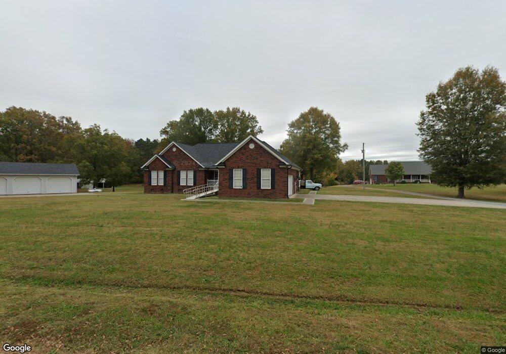
221 Baker Rd Monroe, NC 28112
Estimated Value: $675,000 - $913,111
4
Beds
5
Baths
3,890
Sq Ft
$195/Sq Ft
Est. Value
About This Home
This home is located at 221 Baker Rd, Monroe, NC 28112 and is currently estimated at $757,704, approximately $194 per square foot. 221 Baker Rd is a home located in Union County with nearby schools including Prospect Elementary School, Parkwood Middle School, and Parkwood High School.
Ownership History
Date
Name
Owned For
Owner Type
Purchase Details
Closed on
Dec 9, 2022
Sold by
Deese David M
Bought by
Deese Mitchell Sheppard and Deese Kristen Taylor
Current Estimated Value
Purchase Details
Closed on
Sep 30, 2015
Sold by
Walters H Harold and Walters Paula H
Bought by
Deese David M and Deese Evelyn
Purchase Details
Closed on
Aug 23, 2013
Sold by
Sims Rape Jr Johnny Ray and Sims Rape Lorri
Bought by
Deese David M and Deese Harold Walters
Create a Home Valuation Report for This Property
The Home Valuation Report is an in-depth analysis detailing your home's value as well as a comparison with similar homes in the area
Purchase History
We collect this data history from publicly available records. To have your information removed, we recommend requesting removal directly through your county’s website.
| Date | Buyer | Sale Price | Title Company |
|---|---|---|---|
| Deese Mitchell Sheppard | -- | -- | |
| Deese David M | $66,500 | Attorney | |
| Deese David M | $132,300 | None Available |
Source: Public Records
Tax History
| Year | Tax Paid | Tax Assessment Tax Assessment Total Assessment is a certain percentage of the fair market value that is determined by local assessors to be the total taxable value of land and additions on the property. | Land | Improvement |
|---|---|---|---|---|
| 2025 | $3,760 | $815,700 | $135,900 | $679,800 |
| 2024 | $3,131 | $500,800 | $53,400 | $447,400 |
| 2023 | $3,109 | $500,800 | $53,400 | $447,400 |
| 2022 | $3,109 | $500,800 | $53,400 | $447,400 |
| 2021 | $3,111 | $496,600 | $53,400 | $443,200 |
| 2020 | $2,832 | $358,770 | $44,570 | $314,200 |
| 2019 | $2,732 | $358,770 | $44,570 | $314,200 |
| 2018 | $2,732 | $358,770 | $44,570 | $314,200 |
| 2017 | $2,912 | $358,800 | $44,600 | $314,200 |
| 2016 | $2,860 | $358,770 | $44,570 | $314,200 |
| 2015 | $2,896 | $358,770 | $44,570 | $314,200 |
| 2014 | $2,413 | $349,320 | $53,350 | $295,970 |
Source: Public Records
Map
Nearby Homes
- 224 Gulledge Parker Rd
- 212 Gulledge Parker Rd
- 105 Eubanks Rd
- 212 Trinity Church Rd
- 18AC W M Griffin Rd
- 176 Griffin Rd
- 0 Trinity Church Rd
- 1415 Trinity Church Rd
- 1720 Trinity Church Rd
- 6590 Camp Creek Rd
- 5413 Austin Rd
- 777 John Doster Rd
- 643 John Doster Rd
- 4907 Delmar Griffin Rd
- 4812 Austin Rd
- 549 John Doster Rd
- 4102 Pigg Mattox Rd
- 3123 Stack Rd
- 2219 State Road S-13-106
- 920 Dewitt Helms Rd
- 221 Baker Rd
- 215 Baker Rd
- 215 Baker Rd
- 238 Baker Rd
- 238 Baker Rd
- 202 Baker Rd
- 231 Baker Rd
- 206 Baker Rd
- 223 Baker Rd
- 117 Baker Rd
- 121 Baker Rd
- 121 Baker Rd
- 115 Baker Rd
- 6924 Wolf Pond Rd
- 119 Baker Rd
- 411 Gulledge Parker Rd
- 407 Gulledge Parker Rd
- 407 Gulledge Parker Rd
- 7116 Wolf Pond Rd
- 6914 Wolf Pond Rd
Your Personal Tour Guide
Ask me questions while you tour the home.