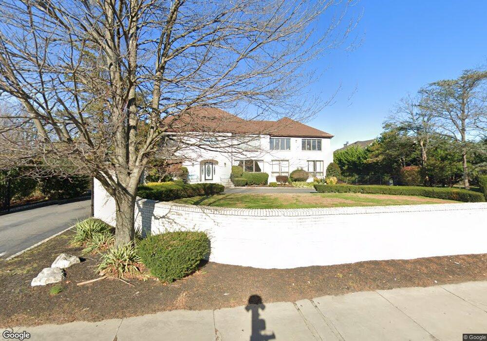
221 Cedar Ave Long Branch, NJ 07740
Estimated Value: $2,153,000 - $3,353,000
5
Beds
3
Baths
4,901
Sq Ft
$548/Sq Ft
Est. Value
About This Home
This home is located at 221 Cedar Ave, Long Branch, NJ 07740 and is currently estimated at $2,685,277, approximately $547 per square foot. 221 Cedar Ave is a home located in Monmouth County with nearby schools including Long Branch High School, Bet Yaakov of the Jersey Shore, and Holy Trinity School.
Ownership History
Date
Name
Owned For
Owner Type
Purchase Details
Closed on
Jan 30, 2017
Sold by
Psb Credit Services Inc
Bought by
Dabah Isaac
Current Estimated Value
Home Financials for this Owner
Home Financials are based on the most recent Mortgage that was taken out on this home.
Original Mortgage
$618,750
Outstanding Balance
$514,011
Interest Rate
4.32%
Mortgage Type
New Conventional
Estimated Equity
$2,171,266
Purchase Details
Closed on
May 15, 2007
Sold by
Mazza James F and Mazza Cecilia K
Bought by
Kohen Saul and Kohen Sari
Home Financials for this Owner
Home Financials are based on the most recent Mortgage that was taken out on this home.
Original Mortgage
$900,000
Interest Rate
6.17%
Mortgage Type
Seller Take Back
Create a Home Valuation Report for This Property
The Home Valuation Report is an in-depth analysis detailing your home's value as well as a comparison with similar homes in the area
Home Values in the Area
Average Home Value in this Area
Purchase History
| Date | Buyer | Sale Price | Title Company |
|---|---|---|---|
| Dabah Isaac | $925,000 | None Available | |
| Kohen Saul | $1,500,001 | Chicago Title Insurance Co |
Source: Public Records
Mortgage History
| Date | Status | Borrower | Loan Amount |
|---|---|---|---|
| Open | Dabah Isaac | $618,750 | |
| Previous Owner | Kohen Saul | $900,000 |
Source: Public Records
Tax History Compared to Growth
Tax History
| Year | Tax Paid | Tax Assessment Tax Assessment Total Assessment is a certain percentage of the fair market value that is determined by local assessors to be the total taxable value of land and additions on the property. | Land | Improvement |
|---|---|---|---|---|
| 2025 | $26,550 | $1,902,200 | $787,100 | $1,115,100 |
| 2024 | $25,520 | $1,727,400 | $569,900 | $1,157,500 |
| 2023 | $25,520 | $1,643,300 | $538,400 | $1,104,900 |
| 2022 | $23,900 | $1,311,600 | $338,200 | $973,400 |
| 2021 | $23,900 | $1,194,400 | $284,200 | $910,200 |
| 2020 | $24,008 | $1,148,700 | $243,700 | $905,000 |
| 2019 | $22,126 | $1,052,600 | $189,700 | $862,900 |
| 2018 | $21,396 | $1,012,100 | $180,700 | $831,400 |
| 2017 | $20,402 | $989,900 | $174,400 | $815,500 |
| 2016 | $19,800 | $979,700 | $185,200 | $794,500 |
| 2015 | $21,181 | $951,100 | $151,000 | $800,100 |
| 2014 | $20,513 | $970,800 | $205,900 | $764,900 |
Source: Public Records
Map
Nearby Homes
- 211 Cedar Ave
- 266 Lenox Ave
- 631 Hoey Ave
- 3 Reid St
- 324 Cedar Ave
- 329 Yorke Ave
- 65 Cedar Ave Unit C11
- 294 Brighton Ave
- 497 Marvin Dr
- 345 Hollywood Ave
- 497 Norwood Ave
- 4 Clarence Ave
- 35 Sternberger Ave Unit P
- 735 Greens Ave Unit 18A
- 45 Cedar Ave
- 448 Monmouth Place
- 280 Cummings Ave
- 388 Brookdale Ave
- 665 2nd Ave Unit 202
- 665 2nd Ave Unit 310
- 728 Shrewsbury Ave
- 729 Bowyer Ave
- 233 Cedar Ave
- 216 Cedar Ave
- 666 Hoey Ave
- 668 Hoey Ave
- 247 Cedar Ave Unit WINTER
- 247 Cedar Ave Unit ANNUAL
- 247 Cedar Ave Unit COTTAGE
- 247 Cedar Ave
- 736 Shrewsbury Ave
- 7 Marshall Ct
- 664 Hoey Ave
- 260 Marshall Ct
- 8 Marshall Ct
- 737 Bowyer Ave
- 656 Hoey Ave
- 240 Cedar Ave
- 9 Marshall Ct
- 192 Cedar Ave