


221 Holley St Biloxi, MS 39530
Estimated payment $56/month
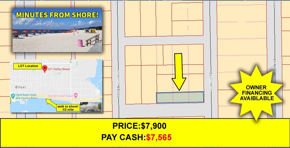
About This Lot
OWNER FINANCING AVAILABLE!!! Low Affordable Monthly Payments! $1335 Down. $125.59 a month 7yr. NO CREDIT CHECK AND LOW PAYMENTS! Direct Message Anytime! 410-428-6800 Call or Text Drew Hill: 410-428-6800 Build your house in this great community! This lot is located on a road that ends at the shore! This property is listed far below market value! We are PropertyWholsalers.net and we find awesome properties at below market values which allows us to make a small profit and pass the savings along to someone else still below market value leaving plenty of options and profit potential! Zoned R1, custom built home or modular/pre-fabrication homes, no trailers, public water, sewer and power. KUHNS 2ND ADD Subdivision, Minutes from Gulfport Beaches and local shopping. Immediately off of Highyway 90. Convenient 25 min to international airport, 1.2 Miles from hard Rock Casino. Parcel number: 1410G-03-020.000 Estimated annual tax: $140.00 Legal Description: Section: 33 Township: 7 Range: 9 Acreage: .1 Lot: 32 X 141 FT S BY 1ST ST E BY HOLLEY ST N BY BELLEW W BY LOT 9 PART OF LOTS 6, 7 & 8 KUHNS 2ND ADD Direct Message Anytime: 410-428-6800 Call or Text Drew Hill: 410-428-6800 *Terms and Conditions: There may be a low documentation fee of for this lot. We will prepare all documentation and record the deed for you. This land is being sold in as is condition. Seller makes no representations, warranties of any kind whatsoever, expressed or implied. All prospects buyers are urged to do their own due diligence to their own satisfaction prior to purchase of this property. All information contained in this listing page has come from reliable sources and is accurate to the best of our knowledge. There will be no delinquent back year taxes at time of conveyance. Current year taxes are the buyers responsibility.

Property Details
Property Type
- Land
Est. Annual Taxes
- $140
Lot Details
- Current uses include residential single
- Potential uses include residential single
Map
Home Values in the Area
Average Home Value in this Area
Tax History
| Year | Tax Paid | Tax Assessment Tax Assessment Total Assessment is a certain percentage of the fair market value that is determined by local assessors to be the total taxable value of land and additions on the property. | Land | Improvement |
|---|---|---|---|---|
| 2024 | $140 | $1,264 | $0 | $0 |
| 2023 | $139 | $1,264 | $0 | $0 |
| 2022 | $139 | $1,264 | $0 | $0 |
| 2021 | $139 | $1,264 | $0 | $0 |
| 2020 | $139 | $0 | $0 | $0 |
| 2019 | $139 | $0 | $0 | $0 |
| 2018 | $139 | $0 | $0 | $0 |
| 2017 | $139 | $1,264 | $0 | $0 |
| 2015 | $139 | $1,264 | $0 | $0 |
| 2014 | -- | $2,106 | $0 | $0 |
| 2013 | -- | $1,264 | $1,264 | $0 |
Property History
| Date | Event | Price | Change | Sq Ft Price |
|---|---|---|---|---|
| 12/18/2024 12/18/24 | For Sale | $7,899 | -- | -- |
Purchase History
| Date | Type | Sale Price | Title Company |
|---|---|---|---|
| Public Action Common In Florida Clerks Tax Deed Or Tax Deeds Or Property Sold For Taxes | -- | -- | |
| Quit Claim Deed | -- | -- |
- 0 Jam Ln
- 916 Camp Four Jacks Rd
- 0 Popps Ferry Rd Unit 4108141
- 0 Popps Ferry Rd Unit 4108136
- 0 Caroline Dr Unit 4117846
- 1853 Popps Ferry Rd
- 932 Bluff Ridge
- 733 Malpass Landing Dr
- 2059 Woodfield Ln
- 891 Palm Cove
- 15712 Poydras Cir
- 2077 Crane Ridge
- 0 Campbell Road Dr Unit 4027188
- 724 Waters View Dr
- 709 Champagne Dr
- 694 Water's View Dr
- 2106 Lauren Dr
- 0 Masterson Ave Unit 4116225
- 2158 Baywood Dr
- 2033 S Hill Dr
- 1955 Popps Ferry Rd
- 1850 Popps Ferry Rd
- 2084 Carolwood Dr
- 2110 Popps Ferry Rd
- 787 Bay Breeze Dr
- 890 Motsie Rd
- 2096 Pat Ln Unit B
- 1693 Vine St
- 333 Belvedere Dr
- 1710 James Buchanan Dr
- 7285 Woolmarket Rd
- 6487 Eastland Cir
- 6603 Eastland Cir
- 270 Mcdonnell Ave
- 1616 Lewis Ave
- 264 Mcdonnell Ave Unit D
- 264 Mcdonnell Ave Unit C
- 264 Mcdonnell Ave Unit B
- 264 Mcdonnell Ave Unit A
- 1997 Todd Cove Unit A