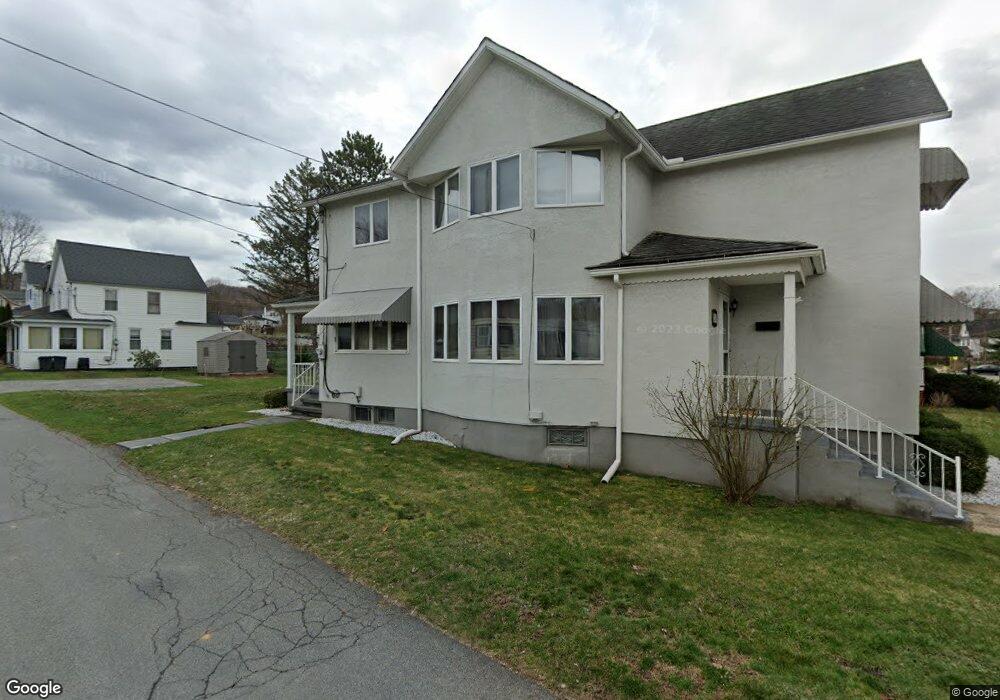
221 Laurel St Archbald, PA 18403
Estimated Value: $169,295 - $252,000
3
Beds
2
Baths
1,552
Sq Ft
$131/Sq Ft
Est. Value
About This Home
This home is located at 221 Laurel St, Archbald, PA 18403 and is currently estimated at $203,824, approximately $131 per square foot. 221 Laurel St is a home located in Lackawanna County with nearby schools including Valley View Intermediate School, Valley View Middle School, and Valley View High School.
Ownership History
Date
Name
Owned For
Owner Type
Purchase Details
Closed on
Sep 15, 2015
Sold by
Ossont Mark D and Ossont Joann
Bought by
Swingle Mark J and Swingle Maureen E
Current Estimated Value
Purchase Details
Closed on
Aug 24, 2009
Sold by
Ossont Mark D and Ossont Joann
Bought by
Ossont Mark D and Ossont Joann
Home Financials for this Owner
Home Financials are based on the most recent Mortgage that was taken out on this home.
Original Mortgage
$100,000
Interest Rate
4.69%
Mortgage Type
New Conventional
Purchase Details
Closed on
Apr 5, 2006
Sold by
Blanchard Jay and Blanchard Sally A
Bought by
Corasiniti Joann and Ossont Mark D
Home Financials for this Owner
Home Financials are based on the most recent Mortgage that was taken out on this home.
Original Mortgage
$15,600
Interest Rate
6.07%
Mortgage Type
Stand Alone Second
Create a Home Valuation Report for This Property
The Home Valuation Report is an in-depth analysis detailing your home's value as well as a comparison with similar homes in the area
Home Values in the Area
Average Home Value in this Area
Purchase History
| Date | Buyer | Sale Price | Title Company |
|---|---|---|---|
| Swingle Mark J | $120,000 | None Available | |
| Ossont Mark D | -- | None Available | |
| Corasiniti Joann | $104,000 | None Available |
Source: Public Records
Mortgage History
| Date | Status | Borrower | Loan Amount |
|---|---|---|---|
| Previous Owner | Ossont Mark D | $100,000 | |
| Previous Owner | Corasiniti Joann | $15,600 |
Source: Public Records
Tax History Compared to Growth
Tax History
| Year | Tax Paid | Tax Assessment Tax Assessment Total Assessment is a certain percentage of the fair market value that is determined by local assessors to be the total taxable value of land and additions on the property. | Land | Improvement |
|---|---|---|---|---|
| 2025 | $1,672 | $6,500 | $1,000 | $5,500 |
| 2024 | $1,435 | $6,500 | $1,000 | $5,500 |
| 2023 | $1,435 | $6,500 | $1,000 | $5,500 |
| 2022 | $1,390 | $6,500 | $1,000 | $5,500 |
| 2021 | $1,387 | $6,500 | $1,000 | $5,500 |
| 2020 | $1,361 | $6,500 | $1,000 | $5,500 |
| 2019 | $1,262 | $6,500 | $1,000 | $5,500 |
| 2018 | $1,239 | $6,500 | $1,000 | $5,500 |
| 2017 | $1,233 | $6,500 | $1,000 | $5,500 |
| 2016 | $549 | $6,500 | $1,000 | $5,500 |
| 2015 | -- | $6,500 | $1,000 | $5,500 |
| 2014 | -- | $6,500 | $1,000 | $5,500 |
Source: Public Records
Map
Nearby Homes
- 217 219 Laurel St
- 00 Hickory St
- 112 Pine St
- 140 Cemetery St
- 121 Ash St
- 0 Forest Ln
- 0 Joel (Lot 30) Dr
- 430 Salem Rd
- 818 Henry St
- 287 Main St Unit REAR STURGES
- 0 Skyline Dr
- 0 Ledgewood Dr
- 462 Delaware St
- 590 N Main St
- 1108 Filbert St
- 1104 E Filbert St
- 1119 E State St
- 0 Joel (Lot 34) Dr Unit GSBSC3073
- 0 Jamie (Lot 11) Dr Unit GSBSC3086
- 0 Joel (Lot 50) Dr Unit GSBSC3078