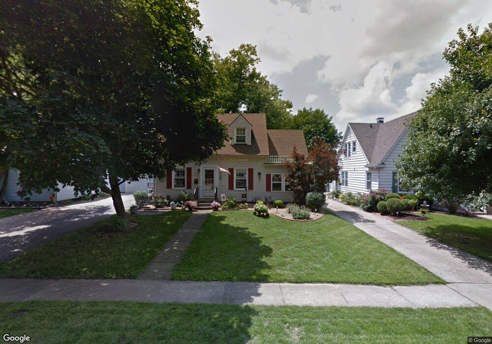
221 N 35th St Mattoon, IL 61938
Estimated Value: $140,000 - $166,000
3
Beds
2
Baths
1,548
Sq Ft
$99/Sq Ft
Est. Value
About This Home
This home is located at 221 N 35th St, Mattoon, IL 61938 and is currently estimated at $153,702, approximately $99 per square foot. 221 N 35th St is a home located in Coles County with nearby schools including Mattoon High School, St Mary School, and St. John's Lutheran School.
Ownership History
Date
Name
Owned For
Owner Type
Purchase Details
Closed on
Aug 21, 2006
Sold by
Herbert Chris C and Herbert Angela M
Bought by
Kirts Sean P and Kirts Barbara J
Current Estimated Value
Home Financials for this Owner
Home Financials are based on the most recent Mortgage that was taken out on this home.
Original Mortgage
$72,000
Outstanding Balance
$43,509
Interest Rate
6.88%
Mortgage Type
New Conventional
Estimated Equity
$110,193
Create a Home Valuation Report for This Property
The Home Valuation Report is an in-depth analysis detailing your home's value as well as a comparison with similar homes in the area
Home Values in the Area
Average Home Value in this Area
Purchase History
| Date | Buyer | Sale Price | Title Company |
|---|---|---|---|
| Kirts Sean P | $114,000 | None Available |
Source: Public Records
Mortgage History
| Date | Status | Borrower | Loan Amount |
|---|---|---|---|
| Open | Kirts Sean P | $72,000 |
Source: Public Records
Tax History Compared to Growth
Tax History
| Year | Tax Paid | Tax Assessment Tax Assessment Total Assessment is a certain percentage of the fair market value that is determined by local assessors to be the total taxable value of land and additions on the property. | Land | Improvement |
|---|---|---|---|---|
| 2024 | $3,374 | $45,622 | $5,126 | $40,496 |
| 2023 | $3,077 | $40,734 | $4,577 | $36,157 |
| 2022 | $2,984 | $40,061 | $4,501 | $35,560 |
| 2021 | $2,972 | $36,797 | $4,134 | $32,663 |
| 2020 | $2,934 | $38,125 | $4,283 | $33,842 |
| 2019 | $2,798 | $36,022 | $4,134 | $31,888 |
| 2018 | $2,748 | $36,022 | $4,134 | $31,888 |
| 2017 | $2,739 | $36,022 | $4,134 | $31,888 |
| 2016 | $2,681 | $36,022 | $4,134 | $31,888 |
| 2015 | $2,644 | $36,022 | $4,134 | $31,888 |
| 2014 | $2,644 | $36,022 | $4,134 | $31,888 |
| 2013 | $2,644 | $36,022 | $4,134 | $31,888 |
Source: Public Records
Map
Nearby Homes
- 3324 Shelby Ave
- 3216 Western Ave
- 231 Circle Dr
- 3304 Marion Ave
- 3512 Walnut Ave
- 2720 Champaign Ave
- 3105 Marshall Ave
- 505 Briar Ln
- 1104 N 32nd St
- 2713 Moultrie Ave
- 1117 N 32nd St
- 2608 Shelby Ave
- 3112 Oak Ave
- 2505 Pine Ave
- 2509 Moultrie Ave
- 2504 Shelby Ave
- 2502 Pine Ave
- 2921 Oak Ave
- 2400 Western Ave
- 2305 Richmond Ave
- 225 N 35th St
- 217 N 35th St
- 229 N 35th St
- 213 N 35th St
- 301 N 35th St
- 209 N 35th St
- 3421 Richmond Ave
- 216 N 35th St
- 305 N 35th St
- 208 N 35th St
- 204 N 35th St
- 205 N 35th St
- 3413 Richmond Ave
- 309 N 35th St
- 3420 Richmond Ave
- 3500 Prairie Ave
- 3409 Richmond Ave
- 3412 Prairie Ave
- 315 N 35th St
- 3408 Prairie Ave