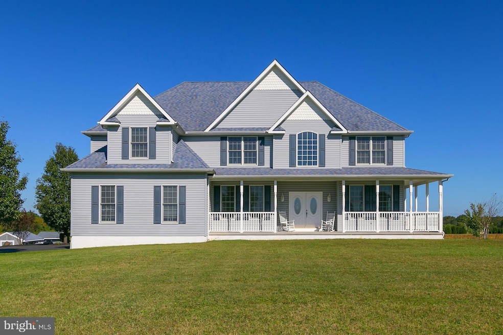
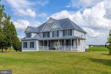
221 Point Airy Rd Pilesgrove, NJ 08098
Estimated payment $4,396/month
Highlights
- View of Trees or Woods
- Dual Staircase
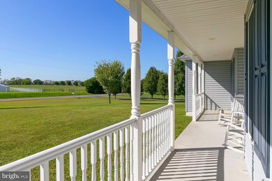
- Deck
- Open Floorplan
- Colonial Architecture
- Main Floor Bedroom
About This Home
Don’t Miss Your Chance to Own a Little Piece of Heaven! 4-5 Bedrooms, 3 Full Baths, 1+ Acre, Custom-Built Beauty
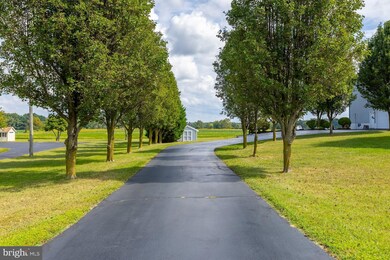
Nestled on just over an acre of serene countryside, this stunning custom-built 4-bedroom + office (could be 5th bedroom), 3-bathroom home offers the perfect blend of peace, privacy, and modern luxury.
Step onto the wraparound porch and let your stress melt away as you take in panoramic views of the surrounding landscape. This is country living at its finest—without sacrificing comfort or convenience.
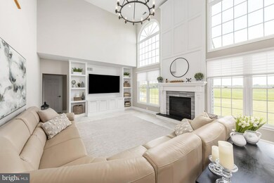
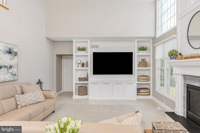
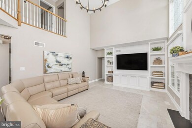
Features You’ll Fall in Love With: New septic system, 9-foot ceilings & crown molding, Energy-efficient Anderson windows, 40-year GAF Timberline roof, Upgraded vinyl siding, 2-zone HVAC for year-round comfort, Upstairs washer and dryer—making putting away laundry a breeze! From the moment you enter the grand two-story foyer with dual staircases, you’ll be welcomed by a neutral color palette and spacious layout. The heart of the home is the two-story family room, boasting: A floor-to-ceiling embellished fireplace with oversized mantle, Built-in entertainment center with storage, Elegant chandelier & custom window treatments, 24x24 Italian ceramic tile flooring. Dream Kitchen Highlights: 42" cabinets & large center island, Double ovens & stainless steel appliances, Leathered granite countertops & tile backsplash, Walk-in pantry, wine rack, wet bar, Stainless hood vented to exterior, Breakfast area with sliding doors to large Trex deck. Enjoy formal gatherings in the elegant dining room with double crown molding, custom window treatments, and sliding glass doors that open to the wraparound porch. There’s also a formal living room—perfect for entertaining or relaxing. A bedroom and full bath on the main level provide flexibility for guests or multi-generational living. Upstairs, you’ll find 4 additional rooms, including an enormous primary suite with: Tray ceiling & sitting area, His and her walk-in closets, Luxurious en-suite bath with dual vanities, Jacuzzi tub & separate shower. The conveniently located upstairs laundry room makes chores easier and more efficient. The walkout basement offers endless potential for future living space—media room, gym, home office, or in-law suite. There is a commercial grade underground fence for pets that goes around the entire property and has two zones. Close to Route 45, Route 40 and 15 min to New Jersey Turnpike entrance. Don't miss your opportunity to make this stunning property your next home. Set up a private showing today.
Listing Agent
(856) 217-3050 narnoldrealestate@gmail.com Keller Williams Hometown Listed on: 10/08/2025

Home Details
Home Type
- Single Family
Est. Annual Taxes
- $11,636
Year Built
- Built in 2002
Lot Details
- 1.14 Acre Lot
- Property has an invisible fence for dogs
- Open Lot
- Back, Front, and Side Yard
- Property is in very good condition
Parking
- 2 Car Direct Access Garage
- 5 Driveway Spaces
- Oversized Parking
- Side Facing Garage
- Garage Door Opener
Property Views
- Woods
- Pasture
Home Design
- Colonial Architecture
- Block Foundation
- Shingle Roof
- Asphalt Roof
- Vinyl Siding
Interior Spaces
- 3,798 Sq Ft Home
- Property has 2 Levels
- Open Floorplan
- Wet Bar
- Dual Staircase
- Built-In Features
- Crown Molding
- Ceiling height of 9 feet or more
- Recessed Lighting
- Stone Fireplace
- Fireplace Mantel
- Gas Fireplace
- Double Pane Windows
- Window Treatments
- Window Screens
- Double Door Entry
- Sliding Doors
- Family Room Off Kitchen
- Combination Kitchen and Living
- Formal Dining Room
- Home Office
- Flood Lights
- Attic
Kitchen
- Breakfast Room
- Eat-In Kitchen
- Walk-In Pantry
- Butlers Pantry
- Built-In Self-Cleaning Double Oven
- Range Hood
- Microwave
- Ice Maker
- Dishwasher
- Stainless Steel Appliances
- Kitchen Island
- Upgraded Countertops
Flooring
- Carpet
- Ceramic Tile
- Luxury Vinyl Plank Tile
Bedrooms and Bathrooms
- 4 Bedrooms
- Main Floor Bedroom
- En-Suite Bathroom
- Walk-In Closet
- Whirlpool Bathtub
- Hydromassage or Jetted Bathtub
- Bathtub with Shower
- Walk-in Shower
Laundry
- Laundry Room
- Laundry on upper level
- Dryer
- Washer
Unfinished Basement
- Walk-Out Basement
- Basement Fills Entire Space Under The House
- Interior and Exterior Basement Entry
- Basement Windows
Eco-Friendly Details
- Energy-Efficient Windows
Outdoor Features
- Deck
- Shed
- Rain Gutters
- Porch
Schools
- Mary S Shoemaker Elementary School
- Woodstown Middle School
- Woodstown High School
Utilities
- Forced Air Heating and Cooling System
- Heating System Powered By Leased Propane
- Vented Exhaust Fan
- 200+ Amp Service
- Water Treatment System
- Well
- Propane Water Heater
- On Site Septic
Community Details
- No Home Owners Association
- Country Setting Subdivision
Listing and Financial Details
- Tax Lot 00009 07
- Assessor Parcel Number 10-00012-00009 07
Map
Home Values in the Area
Average Home Value in this Area
Tax History
| Year | Tax Paid | Tax Assessment Tax Assessment Total Assessment is a certain percentage of the fair market value that is determined by local assessors to be the total taxable value of land and additions on the property. | Land | Improvement |
|---|---|---|---|---|
| 2025 | $14,262 | $390,100 | $76,100 | $314,000 |
| 2024 | $14,469 | $390,100 | $76,100 | $314,000 |
| 2023 | $14,469 | $390,100 | $76,100 | $314,000 |
| 2022 | $13,630 | $390,100 | $76,100 | $314,000 |
| 2021 | $13,127 | $390,100 | $76,100 | $314,000 |
| 2020 | $12,674 | $390,100 | $76,100 | $314,000 |
| 2019 | $12,304 | $390,100 | $76,100 | $314,000 |
| 2018 | $11,730 | $387,400 | $76,100 | $311,300 |
| 2017 | $12,129 | $414,100 | $76,100 | $338,000 |
| 2016 | $11,636 | $414,100 | $76,100 | $338,000 |
| 2015 | $10,767 | $414,100 | $76,100 | $338,000 |
| 2014 | $10,369 | $414,100 | $76,100 | $338,000 |
Property History
| Date | Event | Price | List to Sale | Price per Sq Ft |
|---|---|---|---|---|
| 10/16/2025 10/16/25 | Pending | -- | -- | -- |
| 10/08/2025 10/08/25 | For Sale | $650,000 | -- | $171 / Sq Ft |
Purchase History
| Date | Type | Sale Price | Title Company |
|---|---|---|---|
| Deed | $345,000 | Foundation Title | |
| Bargain Sale Deed | $42,500 | First American Title Ins Co |
Mortgage History
| Date | Status | Loan Amount | Loan Type |
|---|---|---|---|
| Open | $314,381 | New Conventional |
Source: Bright MLS
MLS Number: NJSA2016374
APN: 10-00012-0000-00009-07
Disclaimer: Certain information contained herein is derived from information provided by parties other than Homes.com. All information provided is deemed reliable, but is not guaranteed to be accurate and should be independently verified.
![]() The data relating to real estate for sale on this website appears in part through the BRIGHT Internet Data Exchange program, a voluntary cooperative exchange of property listing data between licensed real estate brokerage firms, and is provided by BRIGHT through a licensing agreement.
The data relating to real estate for sale on this website appears in part through the BRIGHT Internet Data Exchange program, a voluntary cooperative exchange of property listing data between licensed real estate brokerage firms, and is provided by BRIGHT through a licensing agreement.
Listing information is from various brokers who participate in the Bright MLS IDX program and not all listings may be visible on the site.
The property information being provided on or through the website is for the personal, non-commercial use of consumers and such information may not be used for any purpose other than to identify prospective properties consumers may be interested in purchasing.
Some properties which appear for sale on the website may no longer be available because they are for instance, under contract, sold or are no longer being offered for sale.
Property information displayed is deemed reliable but is not guaranteed.
Copyright 2025 Bright MLS, Inc.
- 230 Point Airy Rd
- 96 Kingsberry Ln
- 73 Kingsberry Ln
- 29 Kingsberry Ln
- 8 Eichmann Way
- 236 E Lake Rd
- 50 Colson Ct
- 15 E Grant St
- 36 Bowen Ave
- 0 Woodstown Rd Unit NJSA2016854
- 24 East Ave
- 106 Harrisonville Lake Rd
- 47 Dickinson St
- 63 Wynnwood St
- L13 Highway 40 W
- 178 E Millbrooke Ave
- 15 Magnolia Ct
- 35 Green St
- 39 Green St
- 133 Spring Garden St