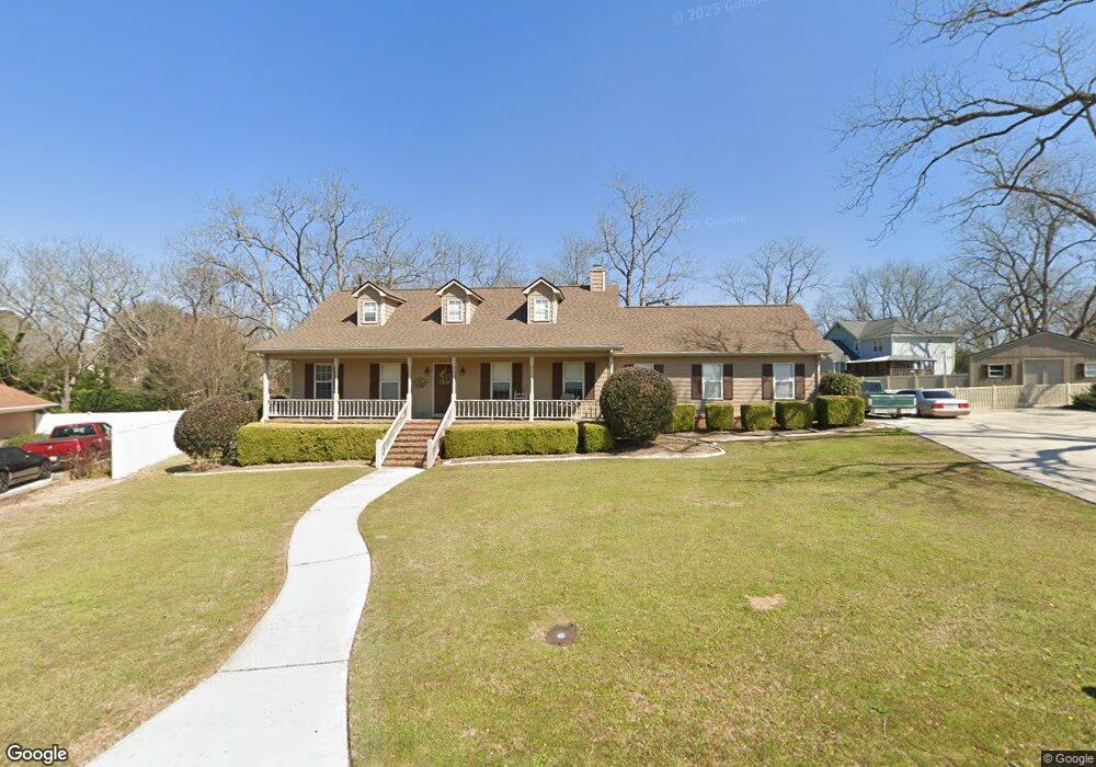
221 Silver Cir Warner Robins, GA 31093
Estimated Value: $271,000 - $320,000
3
Beds
4
Baths
2,424
Sq Ft
$119/Sq Ft
Est. Value
About This Home
This home is located at 221 Silver Cir, Warner Robins, GA 31093 and is currently estimated at $289,518, approximately $119 per square foot. 221 Silver Cir is a home located in Houston County with nearby schools including Northside Elementary School, Thomson Middle School, and Northside High School.
Ownership History
Date
Name
Owned For
Owner Type
Purchase Details
Closed on
Feb 28, 2001
Sold by
Papizan Ronald L and Papizan Anica G
Bought by
Stults William C and Stults Kimberly R
Current Estimated Value
Purchase Details
Closed on
Jan 5, 1999
Sold by
Papizan Ronald L
Bought by
Papizan Ronald L and Papizan Anica G
Purchase Details
Closed on
Dec 10, 1998
Sold by
Papizan Anica G
Bought by
Papizan Ronald L
Purchase Details
Closed on
May 29, 1992
Sold by
Papizan Ronald L
Bought by
Papizan Ronald L and Papizan Anica G
Purchase Details
Closed on
Mar 6, 1992
Sold by
Papizan Anica G
Bought by
Papizan Ronald L
Purchase Details
Closed on
May 25, 1990
Sold by
Mcdaniel & Moore Development C
Bought by
Papizan Ronald L and Papizan Anica G
Purchase Details
Closed on
Dec 29, 1989
Sold by
Antebellum South Inc
Bought by
Mcdaniel & Moore Development Co
Create a Home Valuation Report for This Property
The Home Valuation Report is an in-depth analysis detailing your home's value as well as a comparison with similar homes in the area
Home Values in the Area
Average Home Value in this Area
Purchase History
| Date | Buyer | Sale Price | Title Company |
|---|---|---|---|
| Stults William C | $154,800 | -- | |
| Papizan Ronald L | -- | -- | |
| Papizan Ronald L | -- | -- | |
| Papizan Ronald L | -- | -- | |
| Papizan Ronald L | -- | -- | |
| Papizan Ronald L | -- | -- | |
| Mcdaniel & Moore Development Co | -- | -- |
Source: Public Records
Tax History Compared to Growth
Tax History
| Year | Tax Paid | Tax Assessment Tax Assessment Total Assessment is a certain percentage of the fair market value that is determined by local assessors to be the total taxable value of land and additions on the property. | Land | Improvement |
|---|---|---|---|---|
| 2024 | $2,437 | $101,880 | $11,000 | $90,880 |
| 2023 | $1,957 | $80,960 | $11,000 | $69,960 |
| 2022 | $1,604 | $66,360 | $8,200 | $58,160 |
| 2021 | $1,518 | $62,480 | $8,200 | $54,280 |
| 2020 | $1,519 | $62,240 | $8,200 | $54,040 |
| 2019 | $1,519 | $62,240 | $8,200 | $54,040 |
| 2018 | $1,519 | $62,240 | $8,200 | $54,040 |
| 2017 | $1,527 | $62,480 | $8,200 | $54,280 |
| 2016 | $1,529 | $62,480 | $8,200 | $54,280 |
| 2015 | $1,532 | $62,480 | $8,200 | $54,280 |
| 2014 | -- | $62,480 | $8,200 | $54,280 |
| 2013 | -- | $62,480 | $8,200 | $54,280 |
Source: Public Records
Map
Nearby Homes
- 315 Silver Cir
- 4001 U S 41 Unit LOT 65
- 411 High View Way
- 306 Antebellum Cir
- 133 Peach Rd
- 211 River Birch Way
- 207 Longleaf Dr
- 102 Winged Elm Grove
- 205 Longleaf Dr
- 214 River Birch Way
- 204 River Birch Way
- 104 Winged Elm Grove
- 3915 U S 41
- 27 Centipede Dr
- 140 Coastal Dr
- 214 Coastal Dr
- 211 Coastal Dr
- 318 Air View Dr Unit 10
- Magnolia Plan at Ridgeview
- 320 Air View Dr Unit 11