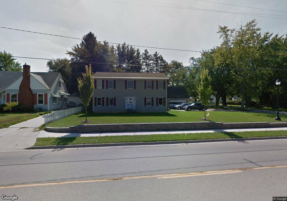
221 W State St Belding, MI 48809
Estimated Value: $285,000 - $356,000
4
Beds
3
Baths
2,288
Sq Ft
$142/Sq Ft
Est. Value
About This Home
This home is located at 221 W State St, Belding, MI 48809 and is currently estimated at $323,798, approximately $141 per square foot. 221 W State St is a home located in Ionia County with nearby schools including Ellis Elementary School, Woodview Elementary School, and Belding Middle School.
Ownership History
Date
Name
Owned For
Owner Type
Purchase Details
Closed on
Mar 12, 2009
Sold by
Hsbc Bank Usa
Bought by
Mathewson Norman
Current Estimated Value
Home Financials for this Owner
Home Financials are based on the most recent Mortgage that was taken out on this home.
Original Mortgage
$74,100
Interest Rate
5.05%
Mortgage Type
Purchase Money Mortgage
Purchase Details
Closed on
Aug 15, 2008
Sold by
Us Bank National Association
Bought by
Hsbc Bank Usa National Association
Purchase Details
Closed on
Aug 7, 2008
Sold by
Chaney John J and Chaney Paula
Bought by
Us Bank National Association and Saxon Mortgage Services Inc
Purchase Details
Closed on
Jul 17, 1998
Bought by
Mathewson Norman
Create a Home Valuation Report for This Property
The Home Valuation Report is an in-depth analysis detailing your home's value as well as a comparison with similar homes in the area
Home Values in the Area
Average Home Value in this Area
Purchase History
| Date | Buyer | Sale Price | Title Company |
|---|---|---|---|
| Mathewson Norman | $74,100 | -- | |
| Hsbc Bank Usa National Association | -- | None Available | |
| Us Bank National Association | $93,500 | None Available | |
| Mathewson Norman | $83,400 | -- |
Source: Public Records
Mortgage History
| Date | Status | Borrower | Loan Amount |
|---|---|---|---|
| Previous Owner | Mathewson Norman | $74,100 |
Source: Public Records
Tax History Compared to Growth
Tax History
| Year | Tax Paid | Tax Assessment Tax Assessment Total Assessment is a certain percentage of the fair market value that is determined by local assessors to be the total taxable value of land and additions on the property. | Land | Improvement |
|---|---|---|---|---|
| 2025 | $3,608 | $188,300 | $15,700 | $172,600 |
| 2024 | $3,380 | $188,300 | $15,700 | $172,600 |
| 2023 | $3,243 | $135,500 | $14,400 | $121,100 |
| 2022 | $3,089 | $135,500 | $14,400 | $121,100 |
| 2021 | $3,207 | $117,400 | $9,300 | $108,100 |
| 2020 | $2,994 | $117,400 | $9,300 | $108,100 |
| 2019 | $2,803 | $107,400 | $8,900 | $98,500 |
| 2018 | $3,137 | $89,800 | $10,200 | $79,600 |
| 2017 | $2,828 | $89,800 | $10,200 | $79,600 |
| 2016 | $2,803 | $76,300 | $6,300 | $70,000 |
| 2015 | -- | $76,300 | $6,300 | $70,000 |
| 2014 | $3,120 | $71,600 | $6,100 | $65,500 |
Source: Public Records
Map
Nearby Homes
- 1017 Pearl St
- 917 S Bridge St
- 110 E Isabelle St
- 717 Pleasant St
- 710 S Broas St
- 121 W Ann St
- 615 Pearl St
- 1323 S Bridge St
- 710 James St
- 107 W Center St
- 115 E Center St
- 404 S Bridge St
- 205 Pearl St
- 509 W Congress St
- 425 Woodland Ave
- 833 Morgan Dr
- 1003 Masonic Ave
- 421 Lewis St
- 129 Midway St
- 222 E Ellis Ave
- 212 W State St
- 1010 Pearl St
- 203 W State St
- 945 Pleasant St
- 224 W State St
- 1021 Pleasant St
- 313 W State St
- 322 W State St
- 941 Pleasant St
- 1011 Pearl St
- 1030 Pearl St
- 1025 Pleasant St
- 933 Pleasant St
- 1006 Pleasant St
- 1004 S Broas St
- 948 Pleasant St
- 1016 Pleasant St
- 324 W State St
- 929 Pleasant St
- 1037 Pearl St