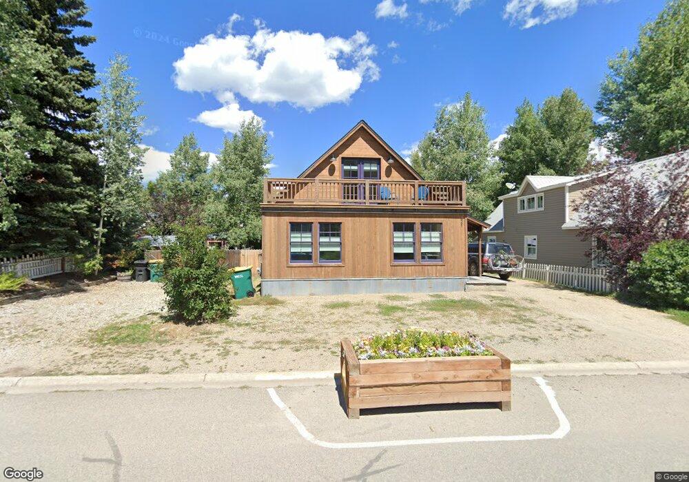
221 Whiterock Ave Crested Butte, CO 81224
Estimated Value: $2,217,000 - $2,554,000
3
Beds
3
Baths
1,875
Sq Ft
$1,277/Sq Ft
Est. Value
About This Home
This home is located at 221 Whiterock Ave, Crested Butte, CO 81224 and is currently estimated at $2,393,457, approximately $1,276 per square foot. 221 Whiterock Ave is a home located in Gunnison County with nearby schools including Gunnison Elementary School, Crested Butte Community School, and Gunnison Middle School.
Ownership History
Date
Name
Owned For
Owner Type
Purchase Details
Closed on
Dec 15, 2023
Sold by
Higuera Michael H
Bought by
Mather Mimi
Current Estimated Value
Purchase Details
Closed on
Sep 10, 2020
Sold by
Cook Stephen
Bought by
Higuera Michael H
Home Financials for this Owner
Home Financials are based on the most recent Mortgage that was taken out on this home.
Original Mortgage
$510,400
Interest Rate
2.9%
Mortgage Type
New Conventional
Create a Home Valuation Report for This Property
The Home Valuation Report is an in-depth analysis detailing your home's value as well as a comparison with similar homes in the area
Home Values in the Area
Average Home Value in this Area
Purchase History
| Date | Buyer | Sale Price | Title Company |
|---|---|---|---|
| Mather Mimi | -- | None Listed On Document | |
| Higuera Michael H | $750,000 | Land Title Guarantee Co |
Source: Public Records
Mortgage History
| Date | Status | Borrower | Loan Amount |
|---|---|---|---|
| Previous Owner | Higuera Michael H | $510,400 |
Source: Public Records
Tax History Compared to Growth
Tax History
| Year | Tax Paid | Tax Assessment Tax Assessment Total Assessment is a certain percentage of the fair market value that is determined by local assessors to be the total taxable value of land and additions on the property. | Land | Improvement |
|---|---|---|---|---|
| 2024 | $12,644 | $183,060 | $18,130 | $164,930 |
| 2023 | $12,644 | $179,380 | $17,770 | $161,610 |
| 2022 | $5,929 | $75,650 | $15,820 | $59,830 |
| 2021 | $4,302 | $62,350 | $16,270 | $46,080 |
| 2020 | $4,529 | $66,270 | $17,290 | $48,980 |
| 2019 | $4,438 | $66,270 | $17,290 | $48,980 |
| 2018 | $3,609 | $52,060 | $12,100 | $39,960 |
| 2017 | $3,633 | $52,060 | $12,100 | $39,960 |
| 2016 | $3,602 | $54,270 | $12,040 | $42,230 |
| 2015 | $3,495 | $54,270 | $12,040 | $42,230 |
| 2014 | $3,495 | $51,070 | $11,440 | $39,630 |
Source: Public Records
Map
Nearby Homes
- 513 Third St
- 308 Whiterock Ave
- 223 Sopris Ave
- 209 Whiterock Ave
- 309 Belleview #2-C Residential Unit 2-C
- 309 Belleview #2-B Residential Unit 2-B
- 309 Belleview #2-A Residential Unit 2-A
- 602 & 604 Fourth St
- 315 Elk Ave
- 413 2nd St
- 609 2nd St
- 218 Maroon Ave Unit E
- 418 Elk Ave
- 310 2nd St
- 398 Journey's End Rd
- 414 Maroon Ave
- 119 Elk Ave
- 108 Maroon Ave Unit B
- 22 Elk Ave
- 28 Whiterock Ave Unit 2
- 225 Whiterock Ave
- 215 Whiterock Ave
- 219 Whiterock Ave
- 226 Whiterock Ave
- 222 Whiterock Ave
- 220 Whiterock Ave
- 605 Third St
- 228 Whiterock Ave
- 228 Whiterock Ave Unit A
- 210 Whiterock Ave
- 222 Sopris Ave
- 214 Sopris Ave
- 226 Sopris Ave
- 206 Whiterock Ave
- 516 3rd St
- 503 3rd St
- 514 3rd St
- 212 Sopris Ave
- 611 3rd St Unit A
- 302 Whiterock Ave