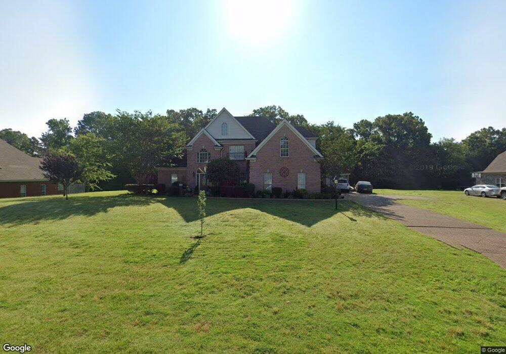
2210 Legends Dr Nesbit, MS 38651
Pleasant Hill NeighborhoodEstimated Value: $393,000 - $487,000
4
Beds
3
Baths
3,338
Sq Ft
$136/Sq Ft
Est. Value
About This Home
This home is located at 2210 Legends Dr, Nesbit, MS 38651 and is currently estimated at $453,604, approximately $135 per square foot. 2210 Legends Dr is a home located in DeSoto County with nearby schools including DeSoto Central Primary School, DeSoto Central Elementary School, and DeSoto Central Middle School.
Ownership History
Date
Name
Owned For
Owner Type
Purchase Details
Closed on
Jun 25, 2008
Sold by
Federal National Mortgage Association
Bought by
Valle Louie and Valle Tammy
Current Estimated Value
Home Financials for this Owner
Home Financials are based on the most recent Mortgage that was taken out on this home.
Original Mortgage
$150,000
Outstanding Balance
$94,969
Interest Rate
5.96%
Mortgage Type
Purchase Money Mortgage
Estimated Equity
$358,635
Purchase Details
Closed on
Nov 15, 2007
Sold by
Bancorpsouth Bank
Bought by
Federal National Mortgage Association
Create a Home Valuation Report for This Property
The Home Valuation Report is an in-depth analysis detailing your home's value as well as a comparison with similar homes in the area
Home Values in the Area
Average Home Value in this Area
Purchase History
| Date | Buyer | Sale Price | Title Company |
|---|---|---|---|
| Valle Louie | -- | Mississippi Title & Appraisa | |
| Federal National Mortgage Association | -- | None Available | |
| Bancorpsouth Bank | $216,000 | None Available |
Source: Public Records
Mortgage History
| Date | Status | Borrower | Loan Amount |
|---|---|---|---|
| Open | Valle Louie | $150,000 |
Source: Public Records
Tax History
| Year | Tax Paid | Tax Assessment Tax Assessment Total Assessment is a certain percentage of the fair market value that is determined by local assessors to be the total taxable value of land and additions on the property. | Land | Improvement |
|---|---|---|---|---|
| 2025 | $3,660 | $32,673 | $3,500 | $29,173 |
| 2024 | $3,072 | $23,294 | $3,500 | $19,794 |
| 2023 | $3,072 | $23,294 | $0 | $0 |
| 2022 | $3,301 | $23,294 | $3,500 | $19,794 |
| 2021 | $3,301 | $23,294 | $3,500 | $19,794 |
| 2020 | $3,079 | $21,730 | $3,500 | $18,230 |
| 2019 | $3,079 | $21,730 | $3,500 | $18,230 |
| 2017 | $2,999 | $38,616 | $21,058 | $17,558 |
| 2016 | $2,699 | $21,058 | $3,500 | $17,558 |
| 2015 | $2,999 | $38,616 | $21,058 | $17,558 |
| 2014 | $2,699 | $21,058 | $0 | $0 |
| 2013 | $2,816 | $21,059 | $0 | $0 |
Source: Public Records
Map
Nearby Homes
- 401 Getwell Rd
- 403 Getwell Rd
- 1768 Linden Dr
- 3049 Pleasant Hill Rd
- 3456 Susie Cir
- 3040 Highground Dr
- 3060 Highground Dr
- 2065 Owl Wing Place
- 3250 W Hartland Dr
- 2255 Highground Dr
- 2239 Highground Dr
- 2225 Highground Dr
- 2195 Highground Dr
- 2768 Black Rock Rd
- 2919 S Cherry Dr
- 1777 Starlanding Rd E
- 3491 Hatton Dr
- 3505 Kreunen St
- 2910 Malabar Place
- 1623 Imboden Cove
Your Personal Tour Guide
Ask me questions while you tour the home.