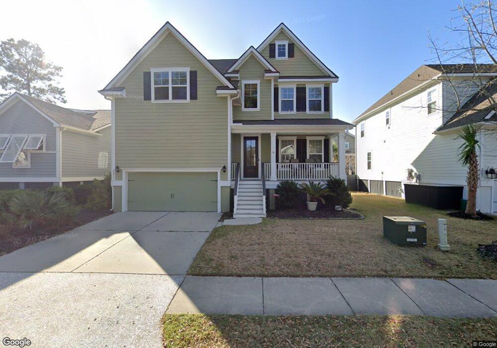
2211 Dewees Creek Dr Mount Pleasant, SC 29466
Oyster Point NeighborhoodEstimated Value: $1,015,801 - $1,200,000
5
Beds
3
Baths
2,665
Sq Ft
$415/Sq Ft
Est. Value
About This Home
This home is located at 2211 Dewees Creek Dr, Mount Pleasant, SC 29466 and is currently estimated at $1,105,700, approximately $414 per square foot. 2211 Dewees Creek Dr is a home located in Charleston County with nearby schools including Mamie Whitesides Elementary School, Moultrie Middle School, and Wando High School.
Ownership History
Date
Name
Owned For
Owner Type
Purchase Details
Closed on
Jul 7, 2015
Sold by
D R Horton Inc
Bought by
Reis Brian C and Asbury Reis Amy M
Current Estimated Value
Home Financials for this Owner
Home Financials are based on the most recent Mortgage that was taken out on this home.
Original Mortgage
$200,000
Outstanding Balance
$156,923
Interest Rate
4.04%
Mortgage Type
Future Advance Clause Open End Mortgage
Estimated Equity
$948,777
Create a Home Valuation Report for This Property
The Home Valuation Report is an in-depth analysis detailing your home's value as well as a comparison with similar homes in the area
Home Values in the Area
Average Home Value in this Area
Purchase History
| Date | Buyer | Sale Price | Title Company |
|---|---|---|---|
| Reis Brian C | $507,920 | -- |
Source: Public Records
Mortgage History
| Date | Status | Borrower | Loan Amount |
|---|---|---|---|
| Open | Reis Brian C | $200,000 |
Source: Public Records
Tax History Compared to Growth
Tax History
| Year | Tax Paid | Tax Assessment Tax Assessment Total Assessment is a certain percentage of the fair market value that is determined by local assessors to be the total taxable value of land and additions on the property. | Land | Improvement |
|---|---|---|---|---|
| 2024 | $2,273 | $22,900 | $0 | $0 |
| 2023 | $2,273 | $22,900 | $0 | $0 |
| 2022 | $2,094 | $22,900 | $0 | $0 |
| 2021 | $2,304 | $22,900 | $0 | $0 |
| 2020 | $2,384 | $22,900 | $0 | $0 |
| 2019 | $2,116 | $20,320 | $0 | $0 |
| 2017 | $2,055 | $20,320 | $0 | $0 |
Source: Public Records
Map
Nearby Homes
- 2242 Dewees Creek Dr
- 1509 W Palmetto Fort Dr
- 3116 Sandy Pearl Way
- 1536 Keshi Pearl Dr
- 3104 Sandy Pearl Way
- 1515 N Lakeshore Dr
- 1613 Fort Palmetto Cir
- 1554 N Lakeshore Dr
- 1494 N Lakeshore Dr
- 1573 Red Tide Rd
- 0 Rifle Range Rd Unit (Lot 2)
- 0 Rifle Range Rd Unit (Lot 1)
- 1750 Cultivation Ln Unit 514
- 2284 Minifarm Way
- 2336 Minifarm Way Unit 507
- 2336 Minifarm Way
- 2276 Minifarm Way Unit 530
- 2276 Minifarm Way
- 1553 Cultivation Ln
- Wando Plan at Liberty Hill Farm
- 2215 Dewees Creek Dr
- 2207 Dewees Creek Dr
- 2203 Dewees Creek Dr
- 2212 Skyler Dr
- 2204 Skyler Dr
- 2202 Skyler Dr
- 2225 Dewees Creek Dr
- 137 Skyler Dr
- 2212 Dewees Creek Dr
- 2216 Dewees Creek Dr
- 2224 Skyler Dr
- 2220 Dewees Creek Dr
- 2208 Dewees Creek Dr
- 128 Dewees Creek Dr
- 125 Dewees Creek Dr
- 129 Dewees Creek Dr
- 123 Dewees Creek Dr
- 2229 Dewees Creek Dr
- 2204 Dewees Creek Dr
- 2209 Skyler Dr