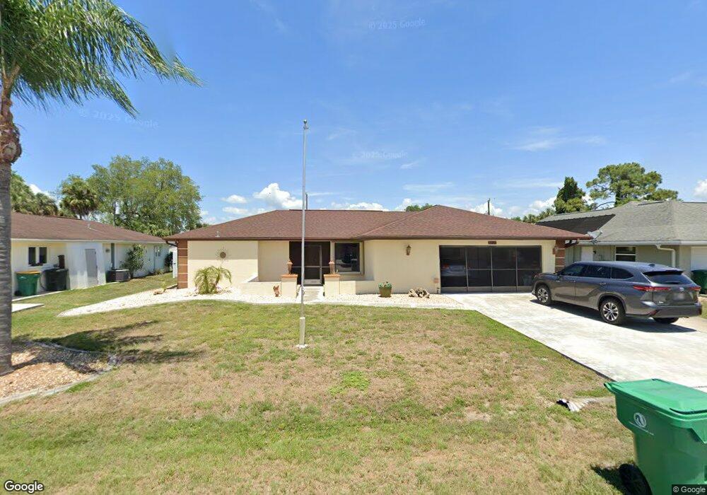
22120 Lancaster Ave Port Charlotte, FL 33952
Estimated Value: $295,982 - $403,000
3
Beds
2
Baths
2,027
Sq Ft
$163/Sq Ft
Est. Value
About This Home
This home is located at 22120 Lancaster Ave, Port Charlotte, FL 33952 and is currently estimated at $330,746, approximately $163 per square foot. 22120 Lancaster Ave is a home located in Charlotte County with nearby schools including Peace River Elementary School, Port Charlotte Middle School, and Charlotte High School.
Ownership History
Date
Name
Owned For
Owner Type
Purchase Details
Closed on
Feb 29, 2016
Sold by
Leventis Dimitrios and Peng Leventis I
Bought by
Wilhoite G Joyce and Wilhoite Douglas E
Current Estimated Value
Purchase Details
Closed on
Apr 27, 2010
Sold by
Deutsche Bank National Trust Company
Bought by
Leventis Dimitrios and Peng Leventis I
Purchase Details
Closed on
Feb 16, 2010
Sold by
Gibbs Robert L and Henkel Marlena C
Bought by
Deutsche Bank National Trust Company
Purchase Details
Closed on
Aug 17, 2001
Sold by
Driscol Barbara A and Driscol John
Bought by
Gibbs Robert L and Henkel Marlena C
Home Financials for this Owner
Home Financials are based on the most recent Mortgage that was taken out on this home.
Original Mortgage
$153,500
Interest Rate
7.18%
Purchase Details
Closed on
Mar 29, 1994
Sold by
Rathbun Willis H
Bought by
Driscol John and Driscol Barbara A
Create a Home Valuation Report for This Property
The Home Valuation Report is an in-depth analysis detailing your home's value as well as a comparison with similar homes in the area
Home Values in the Area
Average Home Value in this Area
Purchase History
| Date | Buyer | Sale Price | Title Company |
|---|---|---|---|
| Wilhoite G Joyce | $175,000 | Attorney | |
| Leventis Dimitrios | $85,000 | Attorney | |
| Deutsche Bank National Trust Company | -- | None Available | |
| Gibbs Robert L | $138,000 | -- | |
| Driscol John | $101,500 | -- |
Source: Public Records
Mortgage History
| Date | Status | Borrower | Loan Amount |
|---|---|---|---|
| Previous Owner | Gibbs Robert L | $153,500 |
Source: Public Records
Tax History Compared to Growth
Tax History
| Year | Tax Paid | Tax Assessment Tax Assessment Total Assessment is a certain percentage of the fair market value that is determined by local assessors to be the total taxable value of land and additions on the property. | Land | Improvement |
|---|---|---|---|---|
| 2023 | $2,638 | $185,332 | $0 | $0 |
| 2022 | $3,016 | $206,242 | $0 | $0 |
| 2021 | $3,008 | $200,235 | $0 | $0 |
| 2020 | $2,950 | $197,470 | $0 | $0 |
| 2019 | $2,846 | $193,030 | $5,015 | $188,015 |
| 2018 | $3,334 | $174,363 | $4,250 | $170,113 |
| 2017 | $3,188 | $162,965 | $4,012 | $158,953 |
| 2016 | $2,715 | $120,309 | $0 | $0 |
| 2015 | $2,463 | $109,372 | $0 | $0 |
| 2014 | $2,247 | $99,429 | $0 | $0 |
Source: Public Records
Map
Nearby Homes
- 3246 Oswego St
- 22220 & 22228 Lockport Ave
- 3255 Geneva St
- 22237 Lockport Ave
- 3413 Westlund Terrace
- 22158 Riverhead Ave
- 3155 Key Ln
- 21536 Holdern Ave
- 3420 Croton Terrace
- 22201 Olean Blvd
- 22271 Morris Ave
- 3436 Lucerne Terrace
- 3124 Crestwood Dr
- 22217 Olean Blvd
- 3132 Crestwood Dr
- 3335 Brooklyn Ave
- 3157 Crestwood Dr
- 3416 Easy St
- 3421 Maple Terrace
- 3341 Croton Terrace
- 22128 Lancaster Ave
- 22112 Lancaster Ave
- 22123 Lockport Ave
- 22115 Lockport Ave
- 22136 Lancaster Ave
- 22131 Lockport Ave
- 22119 Lancaster Ave
- 22107 Lockport Ave
- 22127 Lancaster Ave
- 22111 Lancaster Ave
- 22097 Lockport Ave
- 22144 Lancaster Ave
- 3170 Conway Blvd
- 22103 Lancaster Ave
- 22143 Lancaster Ave
- 22147 Lockport Ave
- 22112 Mamaroneck Ave
- 22124 Lockport Ave
- 22116 Lockport Ave
- 22128 Mamaroneck Ave