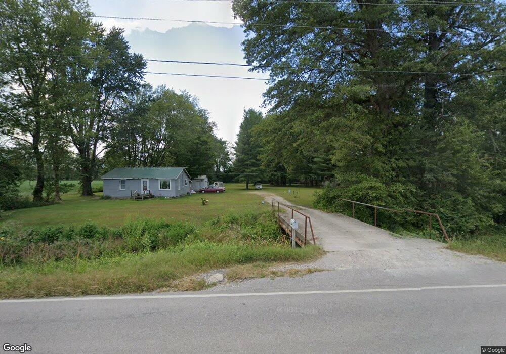
2214 N State Road 135 Freetown, IN 47235
Estimated Value: $87,000 - $224,000
2
Beds
1
Bath
868
Sq Ft
$169/Sq Ft
Est. Value
About This Home
This home is located at 2214 N State Road 135, Freetown, IN 47235 and is currently estimated at $146,498, approximately $168 per square foot. 2214 N State Road 135 is a home located in Jackson County with nearby schools including Brownstown Elementary School, Brownstown Central Middle School, and Brownstown Central High School.
Ownership History
Date
Name
Owned For
Owner Type
Purchase Details
Closed on
Jun 27, 2025
Sold by
Miller Joseph and Miller Sarah B
Bought by
Fluhr Travis
Current Estimated Value
Purchase Details
Closed on
Mar 8, 2021
Sold by
Willcutt Thomas L and Willcutt Velma
Bought by
Miller Joseph R and Miller Sara B
Purchase Details
Closed on
Mar 1, 2021
Sold by
Clements Lorretta and Bischoff Lorretta
Bought by
Thomas L Willcutt And Velma M Willcutt Revoca and Willcutt Velma
Purchase Details
Closed on
Sep 3, 2008
Sold by
Deutsche Bank National Trust Compan
Bought by
Willcutt Thomas L and Willcutt Velma
Purchase Details
Closed on
Jul 3, 2008
Sold by
Lahrman Marc
Bought by
Deutsche Bank National Trust Compa
Purchase Details
Closed on
Apr 26, 2006
Sold by
Beed Roger L and Beed Diana K
Bought by
Beed Roger L and Beed Diana K
Create a Home Valuation Report for This Property
The Home Valuation Report is an in-depth analysis detailing your home's value as well as a comparison with similar homes in the area
Home Values in the Area
Average Home Value in this Area
Purchase History
| Date | Buyer | Sale Price | Title Company |
|---|---|---|---|
| Fluhr Travis | $23,076 | -- | |
| Miller Joseph R | $14,000 | None Available | |
| Thomas L Willcutt And Velma M Willcutt Revoca | -- | None Listed On Document | |
| Willcutt Thomas L | $14,500 | C&R Title Service Llc | |
| Deutsche Bank National Trust Compa | $36,769 | Rothberg Logan & Warsco Llp | |
| Deutsche Bank National Trust Co | $36,768 | None Available | |
| Beed Roger L | -- | None Available |
Source: Public Records
Tax History Compared to Growth
Tax History
| Year | Tax Paid | Tax Assessment Tax Assessment Total Assessment is a certain percentage of the fair market value that is determined by local assessors to be the total taxable value of land and additions on the property. | Land | Improvement |
|---|---|---|---|---|
| 2024 | $1,497 | $92,100 | $27,900 | $64,200 |
| 2023 | $1,651 | $98,500 | $27,900 | $70,600 |
| 2022 | $1,612 | $96,000 | $27,900 | $68,100 |
| 2021 | $389 | $87,600 | $27,900 | $59,700 |
| 2020 | $374 | $86,500 | $27,900 | $58,600 |
| 2019 | $550 | $86,800 | $27,900 | $58,900 |
| 2018 | $354 | $86,100 | $27,900 | $58,200 |
| 2017 | $385 | $85,700 | $27,900 | $57,800 |
| 2016 | $326 | $85,700 | $27,900 | $57,800 |
| 2014 | $365 | $74,800 | $27,900 | $46,900 |
| 2013 | $365 | $74,600 | $27,800 | $46,800 |
Source: Public Records
Map
Nearby Homes
- 3780 W County Road 300 N
- 3264 N County Road 250 W
- 1109 N County Road 600 W Unit Medora
- 4325 N County Road 650 W
- 1319 W Commerce St
- 1109 W Vine St
- 4000 State Road 135
- 290 S State Road 135
- 808 W Bridge St
- 1022 W Raymond St
- 716 W Walnut St
- 702 W Cross St
- 515 Autumn Ct
- 900 W Block Co Rd 50 S
- 960 Buena Vista Dr
- 209 S Block Clark St
- 5804 W County Road 150 S
- 220 W Spring St
- 309 N High St
- 221 N High St
- 4261 W County Road 200 N
- 4457 W County Road 200 N
- 4609 W County Road 200 N
- 2627 N State Road 135
- 1769 N State Road 135
- 2677 N State Road 135
- 4919 W County Road 200 N
- 3535 W County Road 225 N
- 4913 W County Road 200 N
- 4423 W County Road 200 N
- 2244 N County Road 450 W
- 4000 block W Co Rd 300 N 450
- 4000 W County Road 300 N
- 2400 N County Road 450 W
- 1913 N County Road 450 W
- 2626 N County Road 450 W
- 3417 W County Road 225 N
- 2020 N County Road 450 W
- 2807 N State Road 135
- 1789 N County Road 450 W