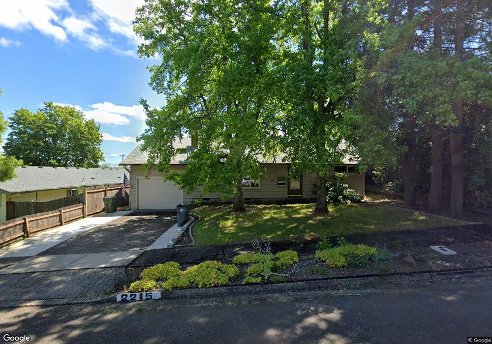
2215 Hayes St Eugene, OR 97405
Far West NeighborhoodEstimated Value: $391,000 - $409,379
3
Beds
1
Bath
1,232
Sq Ft
$326/Sq Ft
Est. Value
About This Home
This home is located at 2215 Hayes St, Eugene, OR 97405 and is currently estimated at $401,095, approximately $325 per square foot. 2215 Hayes St is a home located in Lane County with nearby schools including Cesar Chavez Elementary School, Arts And Technology Academy At Jefferson, and Churchill High School.
Ownership History
Date
Name
Owned For
Owner Type
Purchase Details
Closed on
Dec 25, 2017
Sold by
Whitford Robert R and Whitford Barbara L
Bought by
Whitford B L B and Whitford Robert R
Current Estimated Value
Home Financials for this Owner
Home Financials are based on the most recent Mortgage that was taken out on this home.
Original Mortgage
$197,325
Outstanding Balance
$165,174
Interest Rate
3.9%
Mortgage Type
New Conventional
Estimated Equity
$235,921
Purchase Details
Closed on
Dec 19, 2017
Sold by
Whitford Robert R and Whitford Barbara L
Bought by
Whtford Whtford B and Whtford Robert R
Home Financials for this Owner
Home Financials are based on the most recent Mortgage that was taken out on this home.
Original Mortgage
$197,325
Outstanding Balance
$165,174
Interest Rate
3.9%
Mortgage Type
New Conventional
Estimated Equity
$235,921
Create a Home Valuation Report for This Property
The Home Valuation Report is an in-depth analysis detailing your home's value as well as a comparison with similar homes in the area
Home Values in the Area
Average Home Value in this Area
Purchase History
| Date | Buyer | Sale Price | Title Company |
|---|---|---|---|
| Whitford B L B | -- | Fidelity National Title | |
| Whtford Whtford B | -- | Fidelity National Title |
Source: Public Records
Mortgage History
| Date | Status | Borrower | Loan Amount |
|---|---|---|---|
| Open | Whitford B L B | $197,325 | |
| Closed | Whtford Whtford B | $197,325 |
Source: Public Records
Tax History
| Year | Tax Paid | Tax Assessment Tax Assessment Total Assessment is a certain percentage of the fair market value that is determined by local assessors to be the total taxable value of land and additions on the property. | Land | Improvement |
|---|---|---|---|---|
| 2025 | $3,987 | $204,614 | -- | -- |
| 2024 | $3,937 | $198,655 | -- | -- |
| 2023 | $3,937 | $192,869 | -- | -- |
| 2022 | $3,688 | $187,252 | $0 | $0 |
| 2021 | $3,464 | $181,799 | $0 | $0 |
| 2020 | $3,477 | $176,504 | $0 | $0 |
| 2019 | $3,358 | $171,364 | $0 | $0 |
| 2018 | $3,161 | $161,527 | $0 | $0 |
| 2017 | $3,019 | $161,527 | $0 | $0 |
| 2016 | $2,944 | $156,822 | $0 | $0 |
| 2015 | $2,860 | $152,254 | $0 | $0 |
| 2014 | $2,802 | $147,819 | $0 | $0 |
Source: Public Records
Map
Nearby Homes
- 2190 Pierce St
- 2096 1/2 Arthur St
- 1960 W 25th Ave
- 1955 Arthur St
- 2125 W 19th Place
- 2279 City View St
- 2037 Morning View Dr
- 2064 W 17th Ave
- 1735 Cleveland Place
- 2673 Garfield St
- 1890 Taylor St
- 2070 W 16th Way
- 1935 Mckinley St
- 2095 Polk St
- 1933 W 17th Ave Unit B
- 1935 W 17th Ave Unit B
- 2430 Wilson Dr
- 2225 W 28th Ave
- 1579 Garfield Place Unit 1579
- 1955 W 28th Ave
Your Personal Tour Guide
Ask me questions while you tour the home.