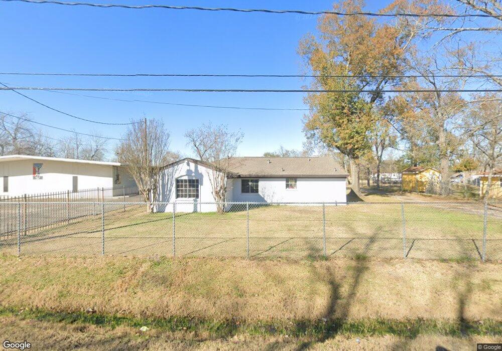
2215 Lone Oak Rd Houston, TX 77093
Estimated Value: $261,000 - $293,257
3
Beds
2
Baths
1,700
Sq Ft
$163/Sq Ft
Est. Value
About This Home
This home is located at 2215 Lone Oak Rd, Houston, TX 77093 and is currently estimated at $276,314, approximately $162 per square foot. 2215 Lone Oak Rd is a home located in Harris County with nearby schools including Scarborough Elementary School, Patrick Henry Middle School, and Sam Houston Math, Science & Technology Center.
Ownership History
Date
Name
Owned For
Owner Type
Purchase Details
Closed on
May 13, 2021
Sold by
Jasso Jose C
Bought by
Jasso Jose Ramon and Jasso Adriana
Current Estimated Value
Home Financials for this Owner
Home Financials are based on the most recent Mortgage that was taken out on this home.
Original Mortgage
$123,500
Outstanding Balance
$111,684
Interest Rate
3.1%
Mortgage Type
New Conventional
Estimated Equity
$164,630
Create a Home Valuation Report for This Property
The Home Valuation Report is an in-depth analysis detailing your home's value as well as a comparison with similar homes in the area
Home Values in the Area
Average Home Value in this Area
Purchase History
| Date | Buyer | Sale Price | Title Company |
|---|---|---|---|
| Jasso Jose Ramon | -- | Capital Title |
Source: Public Records
Mortgage History
| Date | Status | Borrower | Loan Amount |
|---|---|---|---|
| Open | Jasso Jose Ramon | $123,500 |
Source: Public Records
Tax History Compared to Growth
Tax History
| Year | Tax Paid | Tax Assessment Tax Assessment Total Assessment is a certain percentage of the fair market value that is determined by local assessors to be the total taxable value of land and additions on the property. | Land | Improvement |
|---|---|---|---|---|
| 2025 | $3,025 | $269,255 | $92,813 | $176,442 |
| 2024 | $3,025 | $269,255 | $92,813 | $176,442 |
| 2023 | $3,025 | $244,816 | $92,813 | $152,003 |
| 2022 | $4,552 | $244,816 | $92,813 | $152,003 |
| 2021 | $3,724 | $188,614 | $92,813 | $95,801 |
| 2020 | $3,874 | $188,614 | $92,813 | $95,801 |
| 2019 | $4,040 | $188,614 | $92,813 | $95,801 |
| 2018 | $2,678 | $125,000 | $61,875 | $63,125 |
| 2017 | $2,678 | $125,000 | $61,875 | $63,125 |
| 2016 | $2,678 | $125,000 | $61,875 | $63,125 |
| 2015 | $2,674 | $125,000 | $61,875 | $63,125 |
| 2014 | $2,674 | $125,000 | $61,875 | $63,125 |
Source: Public Records
Map
Nearby Homes
- 2122 Kowis St
- 2152 William Tell St
- 2237 Cromwell St
- 2131 Cromwell St Unit D
- 1908 Little York Rd
- 2311 Warwick Rd
- 1930 Cromwell St
- 2636 Lone Oak Rd
- 2629 Kowis St
- 2131 Warwick Rd
- 2123 Warwick Rd
- 2306 Wardmont St
- 2315 Langley Rd
- 2326 Sunny Dr
- 1802 Kowis St
- 1829 Skinner Rd
- 2817 Cromwell St
- 1728 Little York Rd
- 2332 Margaret St
- 1925 Sunny Dr
- 2209 Lone Oak Rd
- 2225 Lone Oak Rd
- 2201 Lone Oak Rd
- 2218 Lone Oak Rd
- 2302 Lone Oak Rd
- 2301 Lone Oak Rd Unit 12
- 2133 Lone Oak Rd
- 2311 Lone Oak Rd
- 2125 Lone Oak Rd
- 2310 Lone Oak Rd
- 2224 Kowis St
- 2211 Trenton Rd
- 2225 Trenton Rd
- 2321 Lone Oak Rd
- 2126 Lone Oak Rd
- 2302 Kowis St
- 2238 Kowis St
- 2210 Kowis St
- 2206 Kowis St
- 2113 Lone Oak Rd