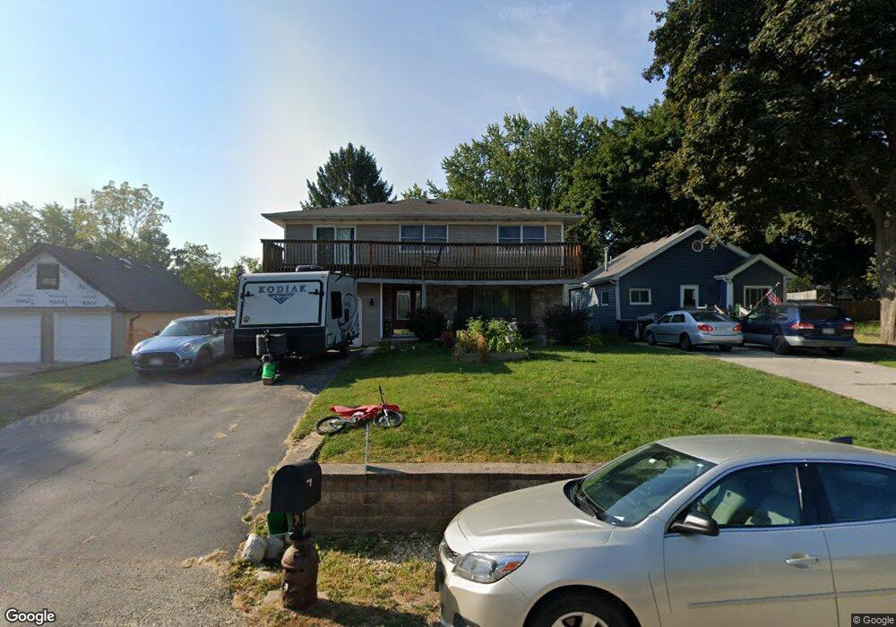
22157 120th St Bristol, WI 53104
Estimated Value: $378,595 - $500,000
5
Beds
3
Baths
2,412
Sq Ft
$183/Sq Ft
Est. Value
About This Home
This home is located at 22157 120th St, Bristol, WI 53104 and is currently estimated at $442,399, approximately $183 per square foot. 22157 120th St is a home located in Kenosha County with nearby schools including Salem Elementary School and Central High School.
Ownership History
Date
Name
Owned For
Owner Type
Purchase Details
Closed on
Nov 8, 2021
Sold by
Crocher and Rachel
Bought by
John Crocher Joseph and John Ann Rachel
Current Estimated Value
Purchase Details
Closed on
Jul 21, 2015
Sold by
Johnson Sean E and Johnson Carri A
Bought by
Crocher Jospeh and Crocher Rachel
Home Financials for this Owner
Home Financials are based on the most recent Mortgage that was taken out on this home.
Original Mortgage
$202,024
Interest Rate
4.11%
Mortgage Type
FHA
Create a Home Valuation Report for This Property
The Home Valuation Report is an in-depth analysis detailing your home's value as well as a comparison with similar homes in the area
Home Values in the Area
Average Home Value in this Area
Purchase History
| Date | Buyer | Sale Price | Title Company |
|---|---|---|---|
| John Crocher Joseph | $240,800 | Fidelity National Title | |
| Crocher Jospeh | $209,000 | -- |
Source: Public Records
Mortgage History
| Date | Status | Borrower | Loan Amount |
|---|---|---|---|
| Previous Owner | Crocher Jospeh | $202,024 |
Source: Public Records
Tax History Compared to Growth
Tax History
| Year | Tax Paid | Tax Assessment Tax Assessment Total Assessment is a certain percentage of the fair market value that is determined by local assessors to be the total taxable value of land and additions on the property. | Land | Improvement |
|---|---|---|---|---|
| 2024 | $5,064 | $321,400 | $43,400 | $278,000 |
| 2023 | $4,684 | $321,400 | $43,400 | $278,000 |
| 2022 | $4,757 | $272,700 | $41,800 | $230,900 |
| 2021 | $4,632 | $272,700 | $41,800 | $230,900 |
| 2020 | $4,788 | $240,800 | $39,500 | $201,300 |
| 2019 | $4,352 | $240,800 | $39,500 | $201,300 |
| 2018 | $3,896 | $199,200 | $37,700 | $161,500 |
| 2017 | $4,193 | $199,200 | $37,700 | $161,500 |
| 2016 | $4,049 | $180,600 | $35,400 | $145,200 |
| 2015 | $3,116 | $158,000 | $35,400 | $122,600 |
| 2014 | $3,235 | $152,000 | $32,900 | $119,100 |
Source: Public Records
Map
Nearby Homes
- 11621 224th Ave
- 21605 117th St
- 22727 126th St
- 12725 228th Ave
- 11736 231st Ct
- 12789 228th Ave
- 12290 233rd Ave
- Lt35 128th St
- 11207 234th Ct
- 198 Bridgewood Dr
- 188 Oakwood Dr
- 12719 234th Ave
- 23607 125th St
- 324 Elmwood Ln
- 394 Birchwood Dr
- 11825 243rd Ave
- 24412 118th St
- 602 Anita Ave
- 42909 N Deep Lake Rd
- 45 Van Dyke Dr
- 22161 120th St
- 22151 120th St
- 22205 120th St
- 22158 120th St
- 22152 120th St
- 22162 120th St
- 22202 120th St
- 22113 120th St
- 22112 121st St
- 22211 120th St
- 22200 121st St
- 22144 120th St
- 22206 120th St
- 22104 121st St
- 22216 121st St
- 22115 121st St
- 22105 120th St
- 22102 121st St
- 12111 222nd Ave
- 22100 120th St