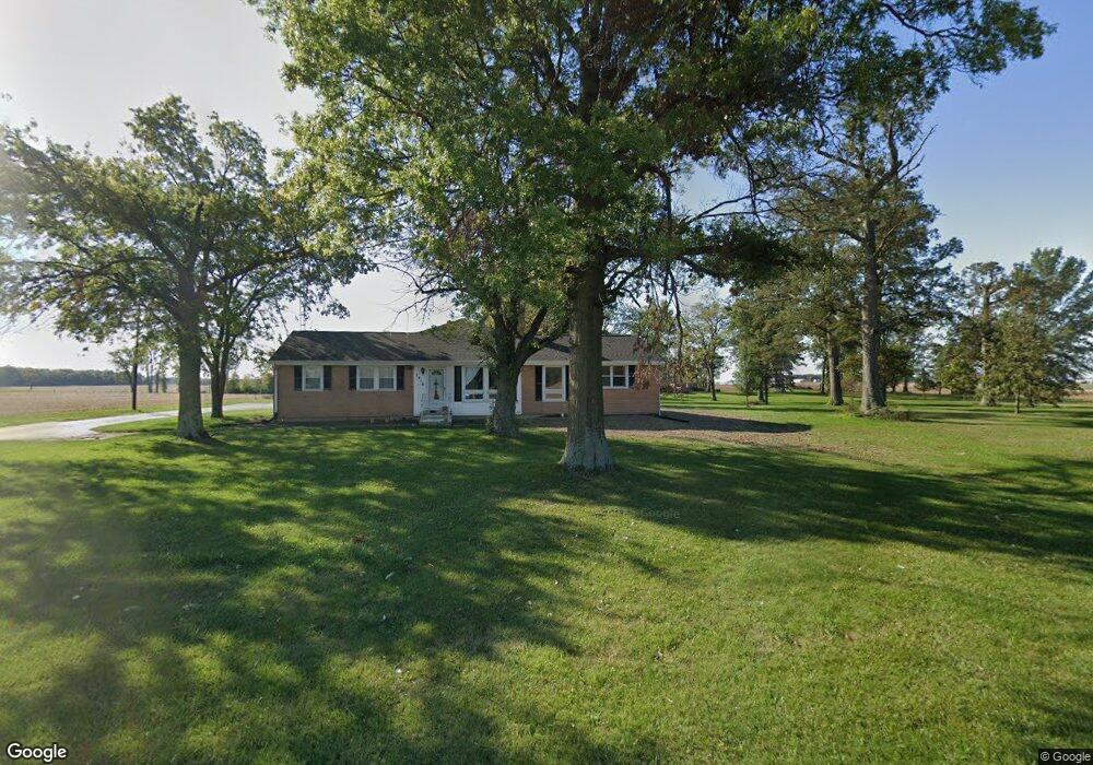
2216 State Route 219 Coldwater, OH 45828
Estimated Value: $262,141 - $366,000
3
Beds
2
Baths
1,560
Sq Ft
$205/Sq Ft
Est. Value
About This Home
This home is located at 2216 State Route 219, Coldwater, OH 45828 and is currently estimated at $319,785, approximately $204 per square foot. 2216 State Route 219 is a home located in Mercer County with nearby schools including Fort Recovery Elementary School, Fort Recovery Middle School, and Fort Recovery High School.
Ownership History
Date
Name
Owned For
Owner Type
Purchase Details
Closed on
Feb 25, 2022
Sold by
Sutter Craig J
Bought by
Metzger Clinton M and Dues Harlie L
Current Estimated Value
Home Financials for this Owner
Home Financials are based on the most recent Mortgage that was taken out on this home.
Original Mortgage
$255,000
Outstanding Balance
$238,252
Interest Rate
3.92%
Mortgage Type
New Conventional
Estimated Equity
$81,533
Purchase Details
Closed on
Sep 14, 2012
Sold by
Sutter Adam J
Bought by
Sutter Craig J
Home Financials for this Owner
Home Financials are based on the most recent Mortgage that was taken out on this home.
Original Mortgage
$74,500
Interest Rate
3.56%
Mortgage Type
New Conventional
Purchase Details
Closed on
Sep 13, 2011
Sold by
Fortkamp Nancy B and Scheer Nancy B
Bought by
Sutter Adam J
Home Financials for this Owner
Home Financials are based on the most recent Mortgage that was taken out on this home.
Original Mortgage
$50,000
Interest Rate
4.4%
Mortgage Type
New Conventional
Create a Home Valuation Report for This Property
The Home Valuation Report is an in-depth analysis detailing your home's value as well as a comparison with similar homes in the area
Home Values in the Area
Average Home Value in this Area
Purchase History
| Date | Buyer | Sale Price | Title Company |
|---|---|---|---|
| Metzger Clinton M | $315,000 | Koesters Judy A | |
| Sutter Craig J | $160,320 | Attorney | |
| Sutter Adam J | $101,000 | Attorney |
Source: Public Records
Mortgage History
| Date | Status | Borrower | Loan Amount |
|---|---|---|---|
| Open | Metzger Clinton M | $255,000 | |
| Previous Owner | Sutter Craig J | $74,500 | |
| Previous Owner | Sutter Adam J | $50,000 |
Source: Public Records
Tax History Compared to Growth
Tax History
| Year | Tax Paid | Tax Assessment Tax Assessment Total Assessment is a certain percentage of the fair market value that is determined by local assessors to be the total taxable value of land and additions on the property. | Land | Improvement |
|---|---|---|---|---|
| 2024 | $1,847 | $63,220 | $6,200 | $57,020 |
| 2023 | $1,847 | $63,220 | $6,200 | $57,020 |
| 2022 | $1,433 | $46,980 | $4,730 | $42,250 |
| 2021 | $1,411 | $46,980 | $4,730 | $42,250 |
| 2020 | $1,442 | $46,100 | $4,730 | $41,370 |
| 2019 | $1,370 | $42,110 | $4,520 | $37,590 |
| 2018 | $1,420 | $42,110 | $4,520 | $37,590 |
| 2017 | $1,378 | $42,110 | $4,520 | $37,590 |
| 2016 | $1,325 | $40,010 | $4,100 | $35,910 |
| 2015 | $1,272 | $40,010 | $4,100 | $35,910 |
| 2014 | $1,272 | $39,380 | $4,100 | $35,280 |
| 2013 | $1,338 | $39,380 | $4,100 | $35,280 |
Source: Public Records
Map
Nearby Homes
- 1291 State Route 219
- 912 Emerald Ave
- 821 Butler St
- 820 Mary Ln
- 401 N Cedar St
- 2332 State Route 29
- 420 S 1st St
- 501 N 2nd St
- 314 E North St
- 402 E Elizabeth St
- 426 E Walnut St
- 721 Lilac Dr
- 6699 Gause Rd
- 207 W Butler St
- 304 S Wayne St
- 201 W Wiggs St
- 0 Anderson Lots 10 11 & 12 Ln Unit 1037885
- 0 Springer 1-6 & Roadway 14-16 Unit 1037883
- 0 Ohio 118
- 0 Anderson 13&14 & Roadway 12&13 Unit 1037886
- 2216 Ohio 219
- 2180 State Route 219
- 2258 State Route 219
- 2168 State Route 219
- 2306 State Route 219
- 2070 State Route 219
- 2368 State Route 219
- 2506 State Route 219
- 4617 Erastus Durbin Rd
- 4754 Burrville Rd
- 2560 State Route 219
- 4328 Erastus Durbin Rd
- 4304 Erastus Durbin Rd
- 4247 Erastus Durbin Rd
- 4288 Erastus Durbin Rd
- 4272 Erastus Durbin Rd
- 4213 Erastus Durbin Rd
- 4131 Burrville Rd