Estimated Value: $257,440 - $297,000
4
Beds
2
Baths
1,883
Sq Ft
$151/Sq Ft
Est. Value
About This Home
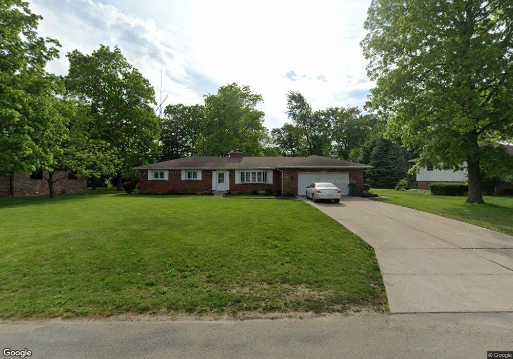
This home is located at 2219 N Brookside Blvd, Genoa, OH 43430 and is currently estimated at $285,110, approximately $151 per square foot. 2219 N Brookside Blvd is a home located in Ottawa County with nearby schools including Genoa Elementary School and Community Christian Academy.
Ownership History
Date
Name
Owned For
Owner Type
Purchase Details
Closed on
Feb 12, 2018
Sold by
Schwasntbeger Troy S and Schwasntbeger Denise T
Bought by
Molnar Timothy S and Molnar Kimberly S
Current Estimated Value
Home Financials for this Owner
Home Financials are based on the most recent Mortgage that was taken out on this home.
Original Mortgage
$166,920
Interest Rate
3.87%
Mortgage Type
FHA
Purchase Details
Closed on
Jun 2, 2017
Sold by
Schwamberger Troy S and Schwamberger Michele Ann
Bought by
Schwamberger Troy S and Schwamberger Dennis T
Purchase Details
Closed on
Apr 13, 2017
Sold by
Lutman Christina L and Wells Fargo Bank Na
Bought by
Schwamberger Troy S
Purchase Details
Closed on
Mar 26, 2014
Sold by
Estate Of Keith A Lutman
Bought by
Lutman Christina L
Purchase Details
Closed on
Nov 19, 2007
Sold by
Hudec Sandra A and Miller Sandra A
Bought by
Lutman Keith A
Home Financials for this Owner
Home Financials are based on the most recent Mortgage that was taken out on this home.
Original Mortgage
$151,304
Interest Rate
6.47%
Mortgage Type
Purchase Money Mortgage
Create a Home Valuation Report for This Property
The Home Valuation Report is an in-depth analysis detailing your home's value as well as a comparison with similar homes in the area
Purchase History
| Date | Buyer | Sale Price | Title Company |
|---|---|---|---|
| Molnar Timothy S | $170,000 | None Available | |
| Schwamberger Troy S | -- | Attorney | |
| Schwamberger Troy S | $97,000 | Attorney | |
| Lutman Christina L | -- | None Available | |
| Lutman Keith A | $152,500 | Attorney |
Source: Public Records
Mortgage History
| Date | Status | Borrower | Loan Amount |
|---|---|---|---|
| Previous Owner | Molnar Timothy S | $166,920 | |
| Previous Owner | Lutman Keith A | $151,304 |
Source: Public Records
Tax History
| Year | Tax Paid | Tax Assessment Tax Assessment Total Assessment is a certain percentage of the fair market value that is determined by local assessors to be the total taxable value of land and additions on the property. | Land | Improvement |
|---|---|---|---|---|
| 2024 | $4,349 | $77,088 | $13,139 | $63,949 |
| 2023 | $3,635 | $56,676 | $10,115 | $46,561 |
| 2022 | $3,120 | $56,676 | $10,115 | $46,561 |
| 2021 | $2,779 | $56,680 | $10,120 | $46,560 |
| 2020 | $2,550 | $48,830 | $6,650 | $42,180 |
| 2019 | $2,530 | $48,830 | $6,650 | $42,180 |
| 2018 | $2,513 | $48,830 | $6,650 | $42,180 |
| 2017 | $2,129 | $40,480 | $6,650 | $33,830 |
| 2016 | $2,136 | $40,480 | $6,650 | $33,830 |
| 2015 | $2,148 | $40,480 | $6,650 | $33,830 |
| 2014 | $962 | $39,280 | $6,650 | $32,630 |
| 2013 | $964 | $39,280 | $6,650 | $32,630 |
Source: Public Records
Map
Nearby Homes
- 23195 W Centerfield Dr
- 1615 N Thyre Dr
- 330 5th St
- 1611 Latcha Rd
- 1309 Superior St
- 1217 Main St
- 416 Castle Cove
- 915 Buckeye St
- 1469 Circle Dr
- 21682 State Route 51 W
- 207 E 11th St
- 904 Main St
- 28262 Brookside Ln
- 1460 Woodville Rd
- 205 W 4th St
- 28955 Bradner Rd
- 1642 Woodville Rd
- 420 E 4th St
- 1861 N Opfer-Lentz Rd
- 1524 Red Bud Dr
- 2207 N Brookside Blvd
- 2231 N Brookside Blvd
- LOT N Brookside Blvd
- 2220 N Manor Dr
- 2251 N Kathy Ln
- 2195 N Brookside Blvd
- 2208 N Manor Dr
- 2232 N Manor Dr
- 2210 N Brookside Blvd
- 2196 N Manor Dr
- 2194 N Brookside Blvd
- 2244 N Manor Dr
- 2183 N Brookside Blvd
- 2214 N Kathy Ln
- 2226 N Kathy Ln
- 2202 N Kathy Ln
- 2238 N Kathy Ln
- 2182 N Brookside Blvd
- 2190 N Kathy Ln
- 2250 N Kathy Ln
Your Personal Tour Guide
Ask me questions while you tour the home.