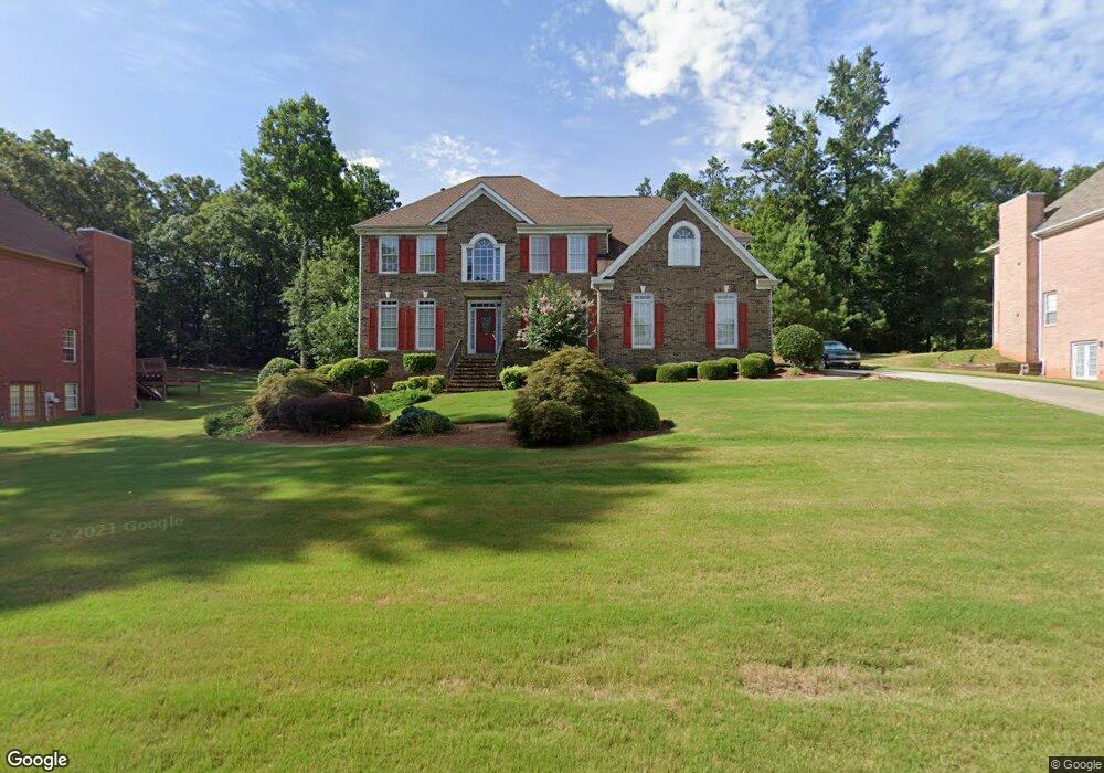
222 Awendaw Cir Ellenwood, GA 30294
Estimated Value: $427,190 - $534,000
5
Beds
3
Baths
3,425
Sq Ft
$137/Sq Ft
Est. Value
About This Home
This home is located at 222 Awendaw Cir, Ellenwood, GA 30294 and is currently estimated at $469,798, approximately $137 per square foot. 222 Awendaw Cir is a home located in Henry County with nearby schools including Austin Road Elementary School, Austin Road Middle School, and Woodland High School.
Ownership History
Date
Name
Owned For
Owner Type
Purchase Details
Closed on
Jun 4, 1999
Sold by
Pb Lindsey Builders Inc
Bought by
Douglas Mark S and Douglas Ramona R
Current Estimated Value
Home Financials for this Owner
Home Financials are based on the most recent Mortgage that was taken out on this home.
Original Mortgage
$210,900
Outstanding Balance
$54,493
Interest Rate
7.04%
Mortgage Type
New Conventional
Estimated Equity
$415,305
Purchase Details
Closed on
Jan 19, 1999
Sold by
Waverly Inc
Bought by
Pb Lindsey Bldrs
Home Financials for this Owner
Home Financials are based on the most recent Mortgage that was taken out on this home.
Original Mortgage
$192,100
Interest Rate
6.85%
Mortgage Type
Construction
Create a Home Valuation Report for This Property
The Home Valuation Report is an in-depth analysis detailing your home's value as well as a comparison with similar homes in the area
Home Values in the Area
Average Home Value in this Area
Purchase History
| Date | Buyer | Sale Price | Title Company |
|---|---|---|---|
| Douglas Mark S | $258,100 | -- | |
| Pb Lindsey Bldrs | $27,000 | -- |
Source: Public Records
Mortgage History
| Date | Status | Borrower | Loan Amount |
|---|---|---|---|
| Open | Douglas Mark S | $210,900 | |
| Previous Owner | Pb Lindsey Bldrs | $192,100 |
Source: Public Records
Tax History Compared to Growth
Tax History
| Year | Tax Paid | Tax Assessment Tax Assessment Total Assessment is a certain percentage of the fair market value that is determined by local assessors to be the total taxable value of land and additions on the property. | Land | Improvement |
|---|---|---|---|---|
| 2025 | $3,932 | $180,200 | $14,000 | $166,200 |
| 2024 | $3,932 | $166,880 | $14,000 | $152,880 |
| 2023 | $4,694 | $160,080 | $12,000 | $148,080 |
| 2022 | $4,620 | $135,560 | $12,000 | $123,560 |
| 2021 | $3,893 | $106,200 | $12,000 | $94,200 |
| 2020 | $3,765 | $102,880 | $8,000 | $94,880 |
| 2019 | $3,521 | $96,520 | $8,000 | $88,520 |
| 2018 | $3,279 | $90,200 | $8,000 | $82,200 |
| 2016 | $3,059 | $84,480 | $7,200 | $77,280 |
| 2015 | $2,810 | $76,080 | $7,200 | $68,880 |
| 2014 | $2,622 | $70,640 | $7,200 | $63,440 |
Source: Public Records
Map
Nearby Homes
- 5520 Hearn Rd
- 103 N Circle Dr
- 4241 Hearn Rd
- 107 S Circle Dr
- 116 Kalsum Trail
- 69 N Hearn Rd
- 0 Kingsbrook Dr Unit 19 LOTS 10399843
- 168 Chapel Ridge Dr
- 120 Bunnie Trail
- 160 Chapel Ridge Dr
- 444 Cauthen Ct
- 429 Saint Surrey Way
- 565 Scarborough Rd
- 500 Saint Sambar Dr
- 4587 Lombard Rd
- 4676 Lake Vista Cir
- 460 Ward Rd
- 176 Fairoaks Cir
- 510 Ward Rd Unit 1
- 4665 River Hill Cir
- 226 Awendaw Cir
- 218 Awendaw Cir
- 221 Awendaw Cir
- 230 Awendaw Cir
- 214 Awendaw Cir
- 350 Boundary Tree Dr
- 229 Awendaw Cir
- 0 Awendaw Cir Unit 8530041
- 0 Awendaw Cir Unit 7533651
- 335 Awendaw Cir
- 234 Awendaw Cir
- 210 Awendaw Cir
- 340 Boundary Tree Dr
- 354 Boundary Tree Dr Unit 2
- 213 Awendaw Cir
- 405 Longridge Ct
- 331 Awendaw Cir
- 238 Awendaw Cir
- 235 Awendaw Cir
- 209 Awendaw Cir