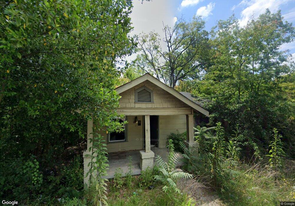
222 Blossom Ave Macon, GA 31204
Estimated Value: $43,000 - $70,000
1
Bed
1
Bath
704
Sq Ft
$80/Sq Ft
Est. Value
About This Home
This home is located at 222 Blossom Ave, Macon, GA 31204 and is currently estimated at $56,197, approximately $79 per square foot. 222 Blossom Ave is a home located in Bibb County with nearby schools including Hartley Elementary School, Southwest High School, and Cirrus Charter Academy.
Ownership History
Date
Name
Owned For
Owner Type
Purchase Details
Closed on
Jul 27, 2005
Sold by
Randall Arthur
Bought by
Parker Donald
Current Estimated Value
Home Financials for this Owner
Home Financials are based on the most recent Mortgage that was taken out on this home.
Original Mortgage
$42,300
Outstanding Balance
$24,962
Interest Rate
7.85%
Mortgage Type
Adjustable Rate Mortgage/ARM
Estimated Equity
$31,235
Purchase Details
Closed on
Apr 28, 2005
Sold by
George Tom and George Mozelle
Bought by
Randall Arthur
Purchase Details
Closed on
Jun 17, 1997
Create a Home Valuation Report for This Property
The Home Valuation Report is an in-depth analysis detailing your home's value as well as a comparison with similar homes in the area
Home Values in the Area
Average Home Value in this Area
Purchase History
| Date | Buyer | Sale Price | Title Company |
|---|---|---|---|
| Parker Donald | $47,000 | None Avilebel | |
| Randall Arthur | $10,000 | None Available | |
| -- | $9,000 | -- |
Source: Public Records
Mortgage History
| Date | Status | Borrower | Loan Amount |
|---|---|---|---|
| Open | Parker Donald | $42,300 |
Source: Public Records
Tax History Compared to Growth
Tax History
| Year | Tax Paid | Tax Assessment Tax Assessment Total Assessment is a certain percentage of the fair market value that is determined by local assessors to be the total taxable value of land and additions on the property. | Land | Improvement |
|---|---|---|---|---|
| 2025 | $260 | $10,573 | $1,980 | $8,593 |
| 2024 | $246 | $9,693 | $1,100 | $8,593 |
| 2023 | $811 | $9,039 | $1,100 | $7,939 |
| 2022 | $272 | $7,846 | $1,333 | $6,513 |
| 2021 | $273 | $7,195 | $1,333 | $5,862 |
| 2020 | $279 | $7,195 | $1,333 | $5,862 |
| 2019 | $282 | $7,195 | $1,333 | $5,862 |
| 2018 | $611 | $7,195 | $1,333 | $5,862 |
| 2017 | $270 | $7,195 | $1,333 | $5,862 |
| 2016 | $374 | $10,808 | $2,666 | $8,142 |
| 2015 | $529 | $10,808 | $2,666 | $8,142 |
| 2014 | $609 | $10,808 | $2,666 | $8,142 |
Source: Public Records
Map
Nearby Homes
- 297 Pansy Ave
- 1568 Marigold Ave
- 1518 Marigold Ave
- 1580 Marigold Ave
- 254 Lilly Ave
- 1485 Brentwood Ave
- 466 Petunia Ave
- 1340 Courtland Ave
- 430 Daffodil St
- 1285 Pio Nono Ave
- 348 Hortman Ave
- 576 Pansy Ave
- 1470 Bankston Ave
- 310 Edwards Ave
- 1495 Ninadel Dr
- 1198 Winton Ave
- 1198 Brentwood Ave
- 2773 Beech Ave
- 1148 Hillyer Ave
- 1195 Brentwood Ave