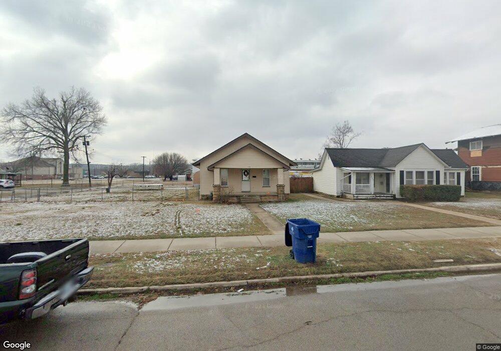
222 E 7th St Pawhuska, OK 74056
Estimated Value: $78,000 - $94,000
3
Beds
1
Bath
1,248
Sq Ft
$70/Sq Ft
Est. Value
About This Home
This home is located at 222 E 7th St, Pawhuska, OK 74056 and is currently estimated at $87,539, approximately $70 per square foot. 222 E 7th St is a home located in Osage County with nearby schools including Indian Camp Elementary School, Pawhuska Elementary School, and Pawhuska Middle School.
Ownership History
Date
Name
Owned For
Owner Type
Purchase Details
Closed on
Jun 2, 2016
Sold by
American Heritage Bank
Bought by
Clifton David G and Clifton Susan L
Current Estimated Value
Purchase Details
Closed on
Oct 19, 2005
Sold by
Dodds Sandra
Bought by
Boe Joseph Wayne and Boe Valarie Lynn
Home Financials for this Owner
Home Financials are based on the most recent Mortgage that was taken out on this home.
Original Mortgage
$25,600
Interest Rate
5.69%
Mortgage Type
New Conventional
Purchase Details
Closed on
Jan 21, 1994
Sold by
Williamson Beulah
Bought by
Whiles Henry C and Whiles Ruby
Create a Home Valuation Report for This Property
The Home Valuation Report is an in-depth analysis detailing your home's value as well as a comparison with similar homes in the area
Home Values in the Area
Average Home Value in this Area
Purchase History
| Date | Buyer | Sale Price | Title Company |
|---|---|---|---|
| Clifton David G | -- | None Available | |
| Boe Joseph Wayne | $32,000 | None Available | |
| Whiles Henry C | $17,500 | -- |
Source: Public Records
Mortgage History
| Date | Status | Borrower | Loan Amount |
|---|---|---|---|
| Previous Owner | Boe Joseph Wayne | $25,600 |
Source: Public Records
Tax History
| Year | Tax Paid | Tax Assessment Tax Assessment Total Assessment is a certain percentage of the fair market value that is determined by local assessors to be the total taxable value of land and additions on the property. | Land | Improvement |
|---|---|---|---|---|
| 2025 | $535 | $5,793 | $500 | $5,293 |
| 2024 | $509 | $5,517 | $500 | $5,017 |
| 2023 | $509 | $5,254 | $500 | $4,754 |
| 2022 | $446 | $4,766 | $500 | $4,266 |
| 2021 | $427 | $4,766 | $500 | $4,266 |
| 2020 | $434 | $4,766 | $500 | $4,266 |
| 2019 | $428 | $4,766 | $500 | $4,266 |
| 2018 | $424 | $4,766 | $500 | $4,266 |
| 2017 | $433 | $4,827 | $500 | $4,327 |
| 2016 | $449 | $4,976 | $500 | $4,476 |
| 2015 | $464 | $4,976 | $500 | $4,476 |
| 2014 | $473 | $4,976 | $500 | $4,476 |
| 2013 | $467 | $4,908 | $500 | $4,408 |
Source: Public Records
Map
Nearby Homes
- 1127 5205 Rd
- 0 Prudom Ave
- 627 Tinker Ave
- 0 Tinker Ave
- 1513 Leahy Ave
- 1017 E 10th St
- 718 Brenner Ave
- 0 E 13th St Unit 2606296
- 1619 Leahy Ave
- 705 Palmer Ave
- 1700 Grandview Ave
- 1715 Grandview Ave
- 501 W 17th St
- 143 Columbus Ave
- 1905 Lynn Ave
- 2006 Lynn Ave
- 1410 Abbott St
- 2401 Grandview Ave
- 102 Oak Rd
- 002 Cr 5101
Your Personal Tour Guide
Ask me questions while you tour the home.