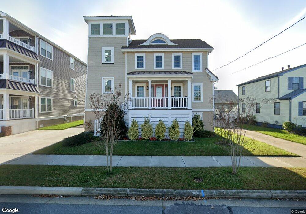
222 E 9th Ave Wildwood, NJ 08260
The Wildwoods NeighborhoodEstimated Value: $810,000 - $1,246,000
Studio
--
Bath
1,930
Sq Ft
$556/Sq Ft
Est. Value
About This Home
This home is located at 222 E 9th Ave, Wildwood, NJ 08260 and is currently estimated at $1,072,748, approximately $555 per square foot. 222 E 9th Ave is a home located in Cape May County with nearby schools including Margaret Mace Elementary School, Wildwood Catholic Academy, and Wildwood Catholic High School.
Ownership History
Date
Name
Owned For
Owner Type
Purchase Details
Closed on
Nov 17, 2001
Sold by
Delia Dominic A
Bought by
Fulton John B and Fulton Joan L
Current Estimated Value
Home Financials for this Owner
Home Financials are based on the most recent Mortgage that was taken out on this home.
Original Mortgage
$150,000
Outstanding Balance
$58,282
Interest Rate
6.64%
Estimated Equity
$1,014,466
Purchase Details
Closed on
Nov 1, 1996
Sold by
Pratta Fred
Bought by
Delia Dominic and Deradorian Debra
Create a Home Valuation Report for This Property
The Home Valuation Report is an in-depth analysis detailing your home's value as well as a comparison with similar homes in the area
Home Values in the Area
Average Home Value in this Area
Purchase History
| Date | Buyer | Sale Price | Title Company |
|---|---|---|---|
| Fulton John B | $190,000 | -- | |
| Delia Dominic | $88,000 | -- |
Source: Public Records
Mortgage History
| Date | Status | Borrower | Loan Amount |
|---|---|---|---|
| Open | Fulton John B | $150,000 |
Source: Public Records
Tax History
| Year | Tax Paid | Tax Assessment Tax Assessment Total Assessment is a certain percentage of the fair market value that is determined by local assessors to be the total taxable value of land and additions on the property. | Land | Improvement |
|---|---|---|---|---|
| 2025 | $7,838 | $505,000 | $250,000 | $255,000 |
| 2024 | $7,671 | $505,000 | $250,000 | $255,000 |
| 2023 | $7,671 | $505,000 | $250,000 | $255,000 |
| 2022 | $7,075 | $505,000 | $250,000 | $255,000 |
| 2021 | $5,243 | $505,000 | $250,000 | $255,000 |
| 2020 | $6,823 | $505,000 | $250,000 | $255,000 |
| 2019 | $6,595 | $505,000 | $250,000 | $255,000 |
| 2018 | $6,408 | $505,000 | $250,000 | $255,000 |
| 2017 | $3,105 | $250,000 | $250,000 | $0 |
| 2016 | $4,111 | $337,500 | $250,000 | $87,500 |
| 2015 | $4,094 | $362,900 | $300,000 | $62,900 |
| 2014 | $3,996 | $362,900 | $300,000 | $62,900 |
Source: Public Records
Map
Nearby Homes
- 108 E 9th Ave
- 119 E 9th Ave
- 125 E 7th Ave Unit 1
- 133 E 12th Ave
- 708 Surf Ave Unit 104
- 103 W 7th Ave
- 1100 New Jersey Ave Unit 104
- 1205 Surf Ave Unit 13
- 1205 Surf Ave Unit 27
- 246 E 14th Ave
- 208 E 4th Ave
- 201 W 10th Ave
- 113 W 6th Ave
- 115 W 6th Ave
- 407 5th Unit D
- 1400 Surf Ave Unit 102
- 405 E 5th Ave Unit C
- 407 E 5th Ave Unit D
- 115 W 14th Ave
- 711 Ocean Ave Unit 108
- 224 E 9th Ave
- 220 E 9th Ave
- 218 E 9th Ave
- 221 E 10th Ave
- 229 E 10th Ave
- 900 Atlantic Ave
- 229 E 9th Ave
- 229 E 9th Ave
- 229 E 9th Ave
- 229 E 9th Ave
- 229 E 9th Ave Unit C
- 229 E 9th Ave Unit B
- 904 Atlantic Ave
- 904 Atlantic Ave Unit A
- 904 Atlantic Ave Unit B
- 216 E 9th Ave
- 215 E 10th Ave
- 225 E 10th Ave
- 231 E 9th Ave
- 906 Atlantic Ave
Your Personal Tour Guide
Ask me questions while you tour the home.