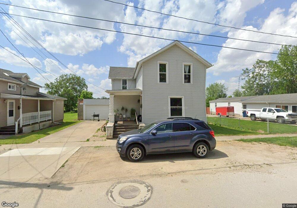
222 Elliot St Fremont, OH 43420
Estimated Value: $47,000 - $129,000
4
Beds
1
Bath
1,536
Sq Ft
$52/Sq Ft
Est. Value
About This Home
This home is located at 222 Elliot St, Fremont, OH 43420 and is currently estimated at $80,373, approximately $52 per square foot. 222 Elliot St is a home located in Sandusky County with nearby schools including Fremont Ross High School, Bishop Hoffman Catholic School - This is St Joe's School now, and St. Joseph School.
Ownership History
Date
Name
Owned For
Owner Type
Purchase Details
Closed on
Sep 13, 2021
Sold by
Freeman Timothy A and Freeman Timothy
Bought by
Tims Properties Llc
Current Estimated Value
Home Financials for this Owner
Home Financials are based on the most recent Mortgage that was taken out on this home.
Original Mortgage
$60,000
Outstanding Balance
$45,873
Interest Rate
2.19%
Estimated Equity
$34,500
Purchase Details
Closed on
Aug 14, 2012
Sold by
Palmer Odelia M
Bought by
Freeman Timothy
Create a Home Valuation Report for This Property
The Home Valuation Report is an in-depth analysis detailing your home's value as well as a comparison with similar homes in the area
Home Values in the Area
Average Home Value in this Area
Purchase History
| Date | Buyer | Sale Price | Title Company |
|---|---|---|---|
| Tims Properties Llc | -- | First American Title | |
| Freeman Timothy | $5,000 | Attorney |
Source: Public Records
Mortgage History
| Date | Status | Borrower | Loan Amount |
|---|---|---|---|
| Open | Tims Properties Llc | $60,000 |
Source: Public Records
Tax History Compared to Growth
Tax History
| Year | Tax Paid | Tax Assessment Tax Assessment Total Assessment is a certain percentage of the fair market value that is determined by local assessors to be the total taxable value of land and additions on the property. | Land | Improvement |
|---|---|---|---|---|
| 2024 | $586 | $15,550 | $4,380 | $11,170 |
| 2023 | $586 | $13,310 | $3,750 | $9,560 |
| 2022 | $527 | $13,310 | $3,750 | $9,560 |
| 2021 | $544 | $13,310 | $3,750 | $9,560 |
| 2020 | $550 | $11,420 | $3,750 | $7,670 |
| 2019 | $473 | $11,420 | $3,750 | $7,670 |
| 2018 | $474 | $11,420 | $3,750 | $7,670 |
| 2017 | $384 | $9,210 | $3,750 | $5,460 |
| 2016 | $338 | $9,210 | $3,750 | $5,460 |
| 2015 | $332 | $9,210 | $3,750 | $5,460 |
| 2014 | $315 | $8,340 | $3,680 | $4,660 |
| 2013 | $309 | $8,340 | $3,680 | $4,660 |
Source: Public Records
Map
Nearby Homes
- 224 Sandusky Ave Unit 226
- 208 E State St
- 516 N Front St
- 433 Sandusky Ave
- 322 4th St
- 427 N Clover St
- 533 Sandusky Ave Unit 535
- 612 2nd St
- 714 E State St
- 515 S Arch St
- 501 Jackson St Unit 50
- 711 Rawson Ave
- 619 Hayes Ave
- 216 S Buchanan St
- 900 Spring St
- 1009 Napoleon St
- 230 N Pennsylvania Ave
- 814 N 5th St
- 1037 Buckland Ave
- 616 S Wood St