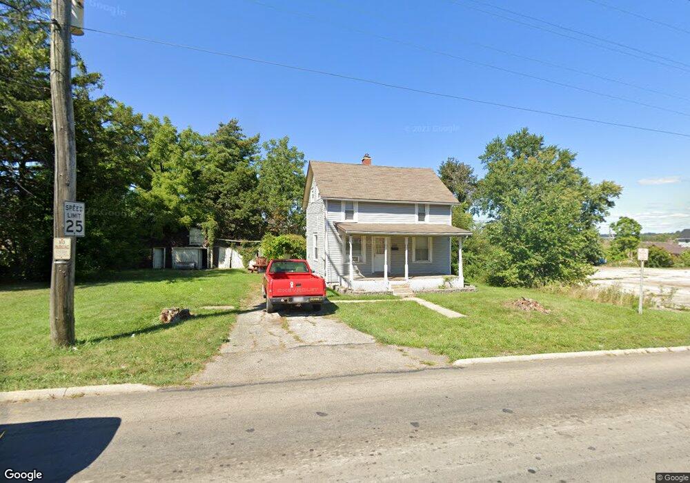
222 Longview Ave W Mansfield, OH 44903
Estimated Value: $32,000 - $97,556
--
Bed
1
Bath
--
Sq Ft
5,009
Sq Ft Lot
About This Home
This home is located at 222 Longview Ave W, Mansfield, OH 44903 and is currently estimated at $77,639. 222 Longview Ave W is a home located in Richland County with nearby schools including Foundation Academy, Mansfield Elective Academy, and St. Peter's Elementary/Montessori School.
Ownership History
Date
Name
Owned For
Owner Type
Purchase Details
Closed on
Mar 7, 2019
Sold by
Rhinehart Kamaurie and Rhinehart Aeriel
Bought by
Healing Hearts Properties Llc
Current Estimated Value
Purchase Details
Closed on
Apr 11, 2016
Sold by
Adkison Donald L
Bought by
Rhinehart Kamaurie and Rhinehart Aeriel
Purchase Details
Closed on
Sep 26, 2011
Sold by
Marsh Bessie May
Bought by
Adkison Donald L
Purchase Details
Closed on
Apr 28, 2011
Sold by
Estate Of Johnny Lee Marsh
Bought by
Marsh Bessie May
Create a Home Valuation Report for This Property
The Home Valuation Report is an in-depth analysis detailing your home's value as well as a comparison with similar homes in the area
Home Values in the Area
Average Home Value in this Area
Purchase History
| Date | Buyer | Sale Price | Title Company |
|---|---|---|---|
| Healing Hearts Properties Llc | $300 | None Available | |
| Rhinehart Kamaurie | $10,000 | Attorney | |
| Adkison Donald L | -- | Attorney | |
| Marsh Bessie May | -- | Attorney |
Source: Public Records
Tax History Compared to Growth
Tax History
| Year | Tax Paid | Tax Assessment Tax Assessment Total Assessment is a certain percentage of the fair market value that is determined by local assessors to be the total taxable value of land and additions on the property. | Land | Improvement |
|---|---|---|---|---|
| 2024 | $98 | $2,050 | $1,420 | $630 |
| 2023 | $98 | $2,050 | $1,420 | $630 |
| 2022 | $110 | $1,920 | $1,290 | $630 |
| 2021 | $110 | $1,920 | $1,290 | $630 |
| 2020 | $113 | $1,920 | $1,290 | $630 |
| 2019 | $125 | $1,920 | $1,290 | $630 |
| 2018 | $124 | $1,920 | $1,290 | $630 |
| 2017 | $145 | $1,920 | $1,290 | $630 |
| 2016 | $170 | $2,640 | $2,040 | $600 |
| 2015 | $163 | $2,640 | $2,040 | $600 |
| 2014 | $161 | $2,640 | $2,040 | $600 |
| 2012 | $130 | $2,780 | $2,150 | $630 |
Source: Public Records
Map
Nearby Homes
- 743 Bowman St
- 283 Bulkley Ave
- 526 Bowman St
- 156 Buckingham Ave Unit 158
- 452 Daisy St
- 0 Highway 30
- 371 Bell St
- 426 Mcpherson St
- 0 Voegele Ave Unit Lot 6048, 6049, 6
- 512 Burns St
- 673 Armstrong St Unit 23
- 356 Warren Rd
- 0 State Route 314 Unit 9067316
- 0 State Route 314 Unit 225021979
- 688 Mcpherson St
- 458 Wayne St
- 282 W 5th St
- 219 W 5th St
- 169 W 5th St
- 346 Newman St
- 216 Longview Ave W
- 702 Bowman St
- 656 Bowman St
- 225 Crestline Ave
- 211 Crestline Ave
- 652 Bowman St
- 215 W Longview Ave
- 712 Bowman St
- 648 Bowman St
- 201 Crestline Ave
- 644 Bowman St
- 655 Bowman St
- 651 Bowman St
- 643 Bowman St
- 641 Bowman St
- 262 Longview Ave W
- 181 Crestline Ave
- 637 Bowman St
- 210 Longview Ave W
- 210 Longview Ave