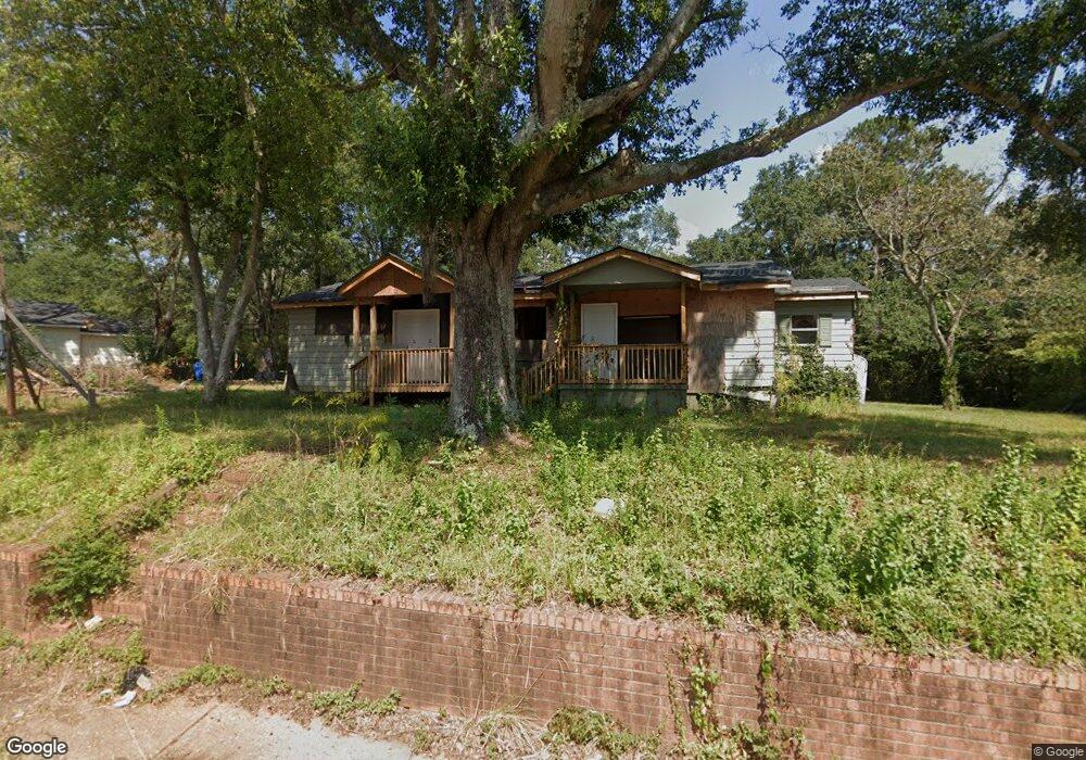
222 Mooty Bridge Rd Lagrange, GA 30240
Estimated Value: $91,416 - $185,000
3
Beds
1
Bath
1,304
Sq Ft
$114/Sq Ft
Est. Value
About This Home
This home is located at 222 Mooty Bridge Rd, Lagrange, GA 30240 and is currently estimated at $148,104, approximately $113 per square foot. 222 Mooty Bridge Rd is a home located in Troup County with nearby schools including Franklin Forest Elementary School, Hollis Hand Elementary School, and Ethel W. Kight Elementary School.
Ownership History
Date
Name
Owned For
Owner Type
Purchase Details
Closed on
Sep 9, 2014
Sold by
Roberts Keith
Bought by
Stanford Samantha
Current Estimated Value
Purchase Details
Closed on
Jun 7, 2011
Sold by
Broughton Jimmy
Bought by
Roberts Keith
Purchase Details
Closed on
Nov 17, 1997
Sold by
Greyfield Resources Inc
Bought by
Broughton Jimmy
Purchase Details
Closed on
Feb 11, 1997
Sold by
Minnifield Louise
Bought by
Greyfield Resources Inc
Purchase Details
Closed on
Oct 9, 1996
Sold by
Louise Minniefield
Bought by
Minnifield Louise
Purchase Details
Closed on
Nov 7, 1995
Sold by
Louise Minniefield
Bought by
Louise Minniefield
Purchase Details
Closed on
Jan 1, 1961
Sold by
Fuller E Callaway Fdn
Bought by
Louise Minniefield
Create a Home Valuation Report for This Property
The Home Valuation Report is an in-depth analysis detailing your home's value as well as a comparison with similar homes in the area
Home Values in the Area
Average Home Value in this Area
Purchase History
| Date | Buyer | Sale Price | Title Company |
|---|---|---|---|
| Stanford Samantha | $5,500 | -- | |
| Roberts Keith | -- | -- | |
| Roberts Keith | -- | -- | |
| Roberts Keith | -- | -- | |
| Broughton Jimmy | -- | -- | |
| Greyfield Resources Inc | $42,000 | -- | |
| Minnifield Louise | -- | -- | |
| Louise Minniefield | $1,500 | -- | |
| Louise Minniefield | -- | -- |
Source: Public Records
Tax History Compared to Growth
Tax History
| Year | Tax Paid | Tax Assessment Tax Assessment Total Assessment is a certain percentage of the fair market value that is determined by local assessors to be the total taxable value of land and additions on the property. | Land | Improvement |
|---|---|---|---|---|
| 2024 | $440 | $16,140 | $4,200 | $11,940 |
| 2023 | $338 | $12,380 | $4,200 | $8,180 |
| 2022 | $331 | $11,860 | $4,200 | $7,660 |
| 2021 | $290 | $9,628 | $4,200 | $5,428 |
| 2020 | $290 | $9,628 | $4,200 | $5,428 |
| 2019 | $286 | $9,496 | $4,200 | $5,296 |
| 2018 | $286 | $9,496 | $4,200 | $5,296 |
| 2017 | $286 | $9,496 | $4,200 | $5,296 |
| 2016 | $486 | $16,128 | $8,400 | $7,728 |
| 2015 | $492 | $16,279 | $8,551 | $7,728 |
| 2014 | $525 | $17,338 | $8,551 | $8,786 |
| 2013 | -- | $19,026 | $9,000 | $10,026 |
Source: Public Records
Map
Nearby Homes
- 900 North St
- 110 Russell St
- 109 Thomas St
- 204 Colonial St
- 219 Banks St
- 145 Turner St
- 806 New Franklin Rd
- 109 Dogwood Dr
- 106 Ewing St
- 102 Ewing St
- 724 Camellia Dr
- 114 Briarcliff Rd
- 0 Ridley Ave Unit 10550104
- 609 Ridley Ave
- 707 Ridley Ave
- 611 Ridley Ave
- 615 Ridley Ave
- 709 Ridley Ave
- 748 Lakewood Dr
- 301 E Bacon St
- 230 Mooty Bridge Rd
- 131 North St
- 218 Mooty Bridge Rd
- 129 North St
- 301 Mooty Bridge Rd
- 138 North St
- 309 Mooty Bridge Rd
- 130 North St
- 144 North St
- 126 North St
- 213 Mooty Bridge Rd
- 110 Stuart St
- 313 Mooty Bridge Rd Unit 279,000
- 108 Stuart St
- 106 Stuart St
- 107 Russell St
- 121 North St
- 113 Stuart St
- 820 N Greenwood St
- 120 North St