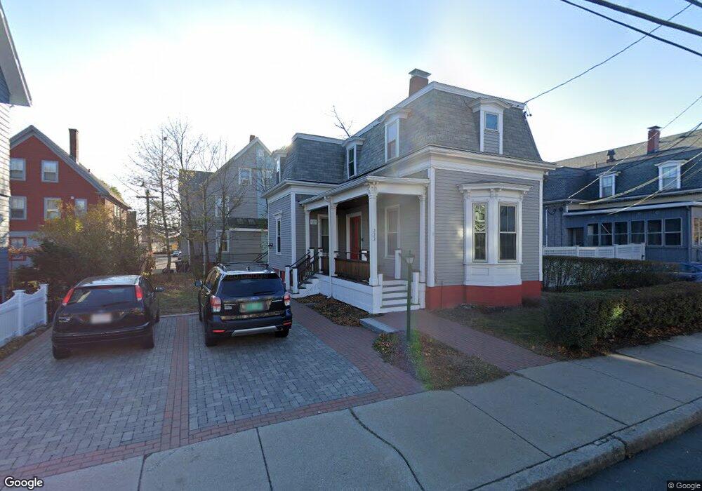
222 Morrison Ave Somerville, MA 02144
Davis Square NeighborhoodEstimated Value: $1,245,000 - $1,448,856
3
Beds
2
Baths
2,220
Sq Ft
$596/Sq Ft
Est. Value
About This Home
This home is located at 222 Morrison Ave, Somerville, MA 02144 and is currently estimated at $1,322,214, approximately $595 per square foot. 222 Morrison Ave is a home located in Middlesex County with nearby schools including Somerville High School, St. Clement Elementary School, and Wild Rose Montessori School.
Ownership History
Date
Name
Owned For
Owner Type
Purchase Details
Closed on
Aug 28, 2025
Sold by
222 Morrison Ave Llc
Bought by
Dorr H Woodward 2025 Ret and Woodward
Current Estimated Value
Purchase Details
Closed on
Sep 1, 2023
Sold by
Woodward Dorr H
Bought by
222 Morrison Ave Llc
Purchase Details
Closed on
Jun 6, 2014
Sold by
Mclellan Margaret E Es and Mclellan Woodward
Bought by
Woodward Dorr H
Create a Home Valuation Report for This Property
The Home Valuation Report is an in-depth analysis detailing your home's value as well as a comparison with similar homes in the area
Home Values in the Area
Average Home Value in this Area
Purchase History
| Date | Buyer | Sale Price | Title Company |
|---|---|---|---|
| Dorr H Woodward 2025 Ret | -- | -- | |
| 222 Morrison Ave Llc | -- | None Available | |
| Woodward Dorr H | -- | -- | |
| Woodward Dorr H | -- | -- |
Source: Public Records
Tax History Compared to Growth
Tax History
| Year | Tax Paid | Tax Assessment Tax Assessment Total Assessment is a certain percentage of the fair market value that is determined by local assessors to be the total taxable value of land and additions on the property. | Land | Improvement |
|---|---|---|---|---|
| 2025 | $13,322 | $1,221,100 | $752,200 | $468,900 |
| 2024 | $12,562 | $1,194,100 | $752,200 | $441,900 |
| 2023 | $12,267 | $1,186,400 | $752,200 | $434,200 |
| 2022 | $11,478 | $1,127,500 | $716,300 | $411,200 |
| 2021 | $11,123 | $1,091,600 | $711,100 | $380,500 |
| 2020 | $10,805 | $1,070,900 | $711,600 | $359,300 |
| 2019 | $10,527 | $978,300 | $647,800 | $330,500 |
| 2018 | $9,920 | $877,100 | $588,900 | $288,200 |
| 2017 | $9,571 | $820,100 | $555,600 | $264,500 |
| 2016 | $8,975 | $716,300 | $496,100 | $220,200 |
| 2015 | $8,533 | $676,700 | $458,200 | $218,500 |
Source: Public Records
Map
Nearby Homes
- 68 Winslow Ave
- 371 Highland Ave
- 353 Summer St Unit 310
- 50 Howard St Unit 5
- 20 Electric Ave Unit 2
- 7 Russell St Unit 1
- 31 Rogers Ave
- 26 Warner St
- 23 Highland Rd
- 5 Glendale Ave Unit 5
- 2353 Massachusetts Ave Unit 73
- 32 Cameron Ave
- 29 Packard Ave
- 7 Beech St Unit 319
- 7 Beech St Unit 211
- 55 Packard Ave Unit 1
- 69 Electric Ave Unit 3
- 69 Electric Ave Unit 2
- 69 Electric Ave Unit 1
- 11 Cogswell Ave Unit 13
- 222 Morrison Ave Unit 2
- 216 Morrison Ave
- 226 Morrison Ave
- 20 Winslow Ave
- 18 Winslow Ave
- 22 Winslow Ave
- 22 Winslow Ave Unit 1
- 14 Winslow Ave
- 214 Morrison Ave
- 26 Winslow Ave
- 223 Morrison Ave Unit R
- 223 Morrison Ave
- 223 Morrison Ave Unit 223
- 208 Morrison Ave
- 208 Morrison Ave Unit 1
- 215 Morrison Ave
- 221 Morrison Ave
- 225 Morrison Ave
- 225 Morrison Ave Unit Left
- 225 Morrison Ave