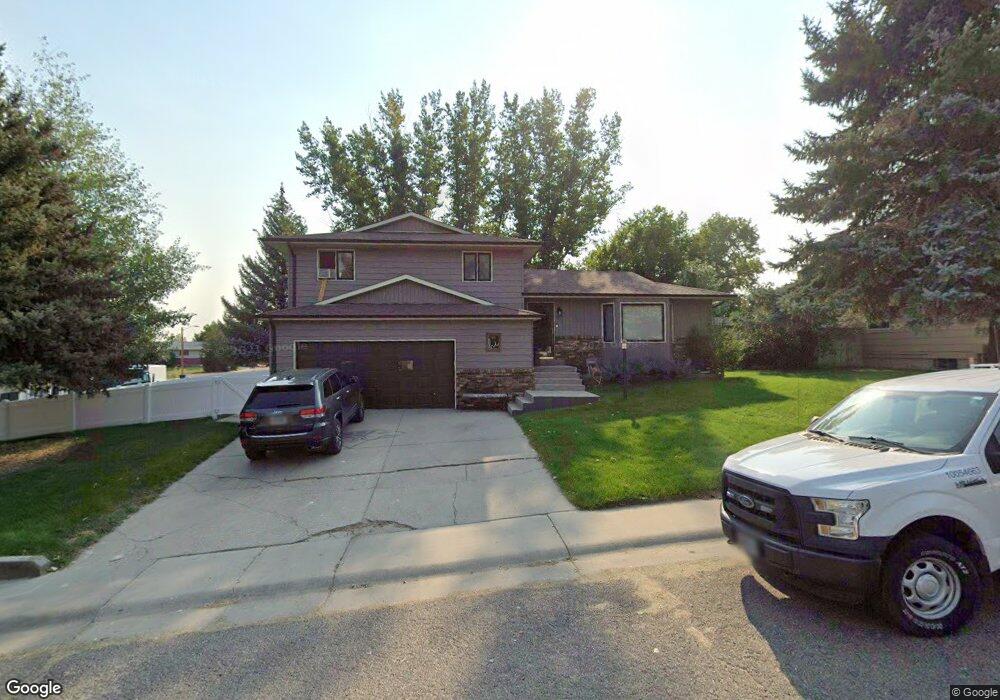
222 Texas Trail Glenrock, WY 82637
Estimated Value: $66,000 - $329,000
3
Beds
3
Baths
1,820
Sq Ft
$138/Sq Ft
Est. Value
About This Home
This home is located at 222 Texas Trail, Glenrock, WY 82637 and is currently estimated at $251,037, approximately $137 per square foot. 222 Texas Trail is a home with nearby schools including Grant Elementary School, Glenrock Intermediate School, and Boxelder Elementary.
Ownership History
Date
Name
Owned For
Owner Type
Purchase Details
Closed on
Jul 30, 2020
Sold by
Zdrojewski Holli S and Garner Holli S
Bought by
Zdrojewski Holli S and Zdrojewski Matthew
Current Estimated Value
Home Financials for this Owner
Home Financials are based on the most recent Mortgage that was taken out on this home.
Original Mortgage
$130,000
Interest Rate
3.1%
Mortgage Type
New Conventional
Purchase Details
Closed on
Oct 31, 2006
Sold by
Garner Woodrow L and Garner Woodrow Lee
Bought by
Garner Holli S
Home Financials for this Owner
Home Financials are based on the most recent Mortgage that was taken out on this home.
Original Mortgage
$99,500
Interest Rate
6.37%
Mortgage Type
New Conventional
Create a Home Valuation Report for This Property
The Home Valuation Report is an in-depth analysis detailing your home's value as well as a comparison with similar homes in the area
Home Values in the Area
Average Home Value in this Area
Purchase History
| Date | Buyer | Sale Price | Title Company |
|---|---|---|---|
| Zdrojewski Holli S | -- | First American Title | |
| Garner Holli S | -- | None Availabel |
Source: Public Records
Mortgage History
| Date | Status | Borrower | Loan Amount |
|---|---|---|---|
| Closed | Zdrojewski Holli S | $130,000 | |
| Closed | Garner Holli S | $99,500 |
Source: Public Records
Tax History Compared to Growth
Tax History
| Year | Tax Paid | Tax Assessment Tax Assessment Total Assessment is a certain percentage of the fair market value that is determined by local assessors to be the total taxable value of land and additions on the property. | Land | Improvement |
|---|---|---|---|---|
| 2025 | $2,160 | $22,673 | $3,849 | $18,824 |
| 2024 | $2,160 | $29,259 | $5,132 | $24,127 |
| 2023 | $2,058 | $27,721 | $4,532 | $23,189 |
| 2022 | $1,936 | $26,300 | $4,368 | $21,932 |
| 2021 | $1,757 | $23,467 | $3,986 | $19,481 |
| 2020 | $1,655 | $22,594 | $3,986 | $18,608 |
| 2019 | $1,656 | $22,299 | $3,986 | $18,313 |
| 2018 | $1,601 | $22,335 | $3,986 | $18,349 |
| 2017 | $1,630 | $22,277 | $3,986 | $18,291 |
| 2015 | $1,640 | $22,091 | $3,713 | $18,378 |
| 2014 | $1,448 | $19,460 | $3,549 | $15,911 |
Source: Public Records
Map
Nearby Homes
- 206 California Trail
- 110 & 120 Sunup Rd
- 400 Sunshine Ln
- Lot 12 Sunup Rd
- 562 Emigrant Dr
- 556 Emigrant Dr
- 550 Emigrant Dr
- 502 Emigrant Dr
- 526 Emigrant Dr
- 514 Emigrant Dr
- 508 Emigrant Dr
- 532 Emigrant Dr
- 538 Emigrant Dr
- 544 Emigrant Dr
- 520 Emigrant Dr
- 532 Windmill Rd
- 409 Claim Draw
- 382 Miller Rd
- Lot 1 Grove St
- Lot 3 Grove St
- 218 Texas Trail
- 247 Fort Laramie
- 214 Texas Trail
- 233 Fort Laramie
- 217 Boxelder Trail
- 217 Shoshoni Trail
- 242 Fort Laramie
- 238 Fort Laramie
- 246 Fort Laramie
- 217 Texas Trail
- 213 Boxelder Trail
- 213 Texas Trail
- 213 Texas Trail Unit Oregon Trail
- 234 Fort Laramie
- 210 Texas Trail
- 210 Texas Trail Unit Oregon Trail
- 250 Fort Laramie
- 250 Fort Laramie Unit Boxelder
- 209 Boxelder Trail
- 209 Texas Trail