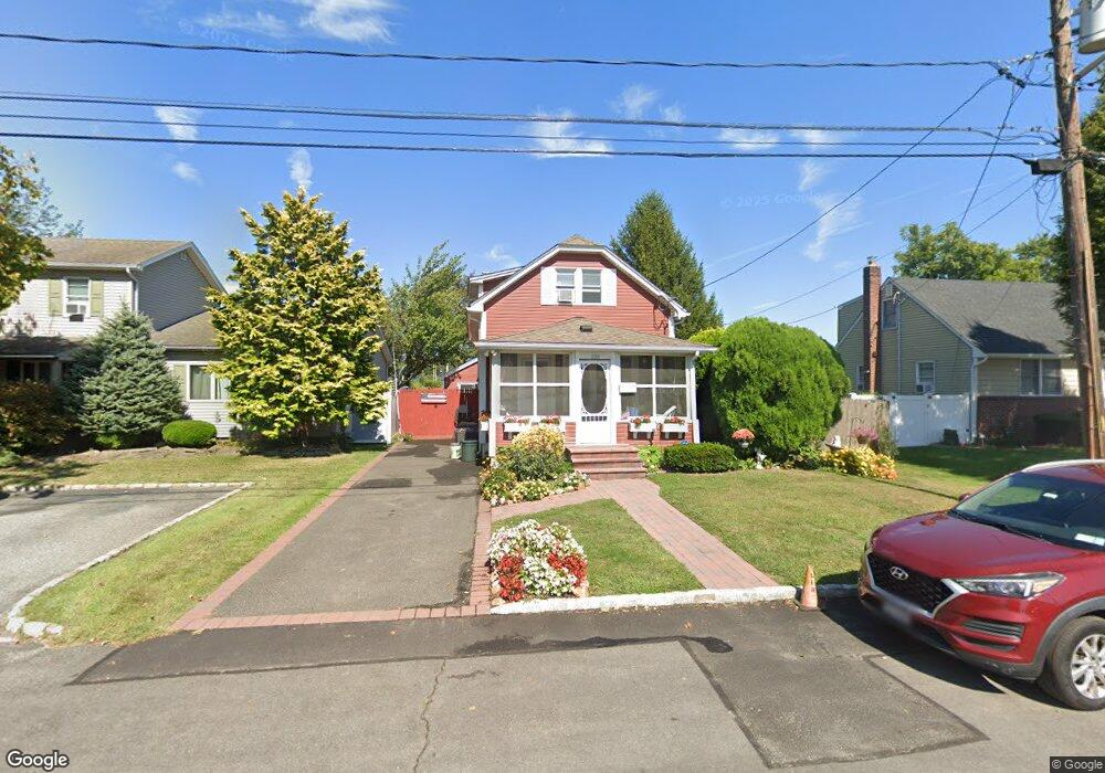
222 Travis St Lindenhurst, NY 11757
Estimated Value: $409,425 - $828,000
--
Bed
2
Baths
1,037
Sq Ft
$620/Sq Ft
Est. Value
About This Home
This home is located at 222 Travis St, Lindenhurst, NY 11757 and is currently estimated at $642,856, approximately $619 per square foot. 222 Travis St is a home located in Suffolk County with nearby schools including Alleghany Avenue School, Lindenhurst Middle School, and Lindenhurst Senior High School.
Ownership History
Date
Name
Owned For
Owner Type
Purchase Details
Closed on
Jan 15, 1998
Sold by
Daly Daniel and Daly Christine
Bought by
Lopez Albert R and Lopez Claudette
Current Estimated Value
Home Financials for this Owner
Home Financials are based on the most recent Mortgage that was taken out on this home.
Original Mortgage
$130,450
Outstanding Balance
$22,580
Interest Rate
7.11%
Estimated Equity
$620,276
Purchase Details
Closed on
May 22, 1997
Sold by
Coughlin Eugene T and Coughlin Theresa R
Bought by
Daly Daniel and Daly Christine
Create a Home Valuation Report for This Property
The Home Valuation Report is an in-depth analysis detailing your home's value as well as a comparison with similar homes in the area
Home Values in the Area
Average Home Value in this Area
Purchase History
| Date | Buyer | Sale Price | Title Company |
|---|---|---|---|
| Lopez Albert R | $134,500 | First American Title Ins Co | |
| Daly Daniel | $111,500 | -- |
Source: Public Records
Mortgage History
| Date | Status | Borrower | Loan Amount |
|---|---|---|---|
| Open | Lopez Albert R | $130,450 |
Source: Public Records
Tax History Compared to Growth
Tax History
| Year | Tax Paid | Tax Assessment Tax Assessment Total Assessment is a certain percentage of the fair market value that is determined by local assessors to be the total taxable value of land and additions on the property. | Land | Improvement |
|---|---|---|---|---|
| 2024 | $8,165 | $2,390 | $230 | $2,160 |
| 2023 | $7,244 | $2,390 | $230 | $2,160 |
| 2022 | $6,065 | $2,390 | $230 | $2,160 |
| 2021 | $6,065 | $2,390 | $230 | $2,160 |
| 2020 | $4,829 | $2,390 | $230 | $2,160 |
| 2019 | $5,649 | $0 | $0 | $0 |
| 2018 | -- | $2,390 | $230 | $2,160 |
| 2017 | $5,983 | $2,390 | $230 | $2,160 |
| 2016 | $6,022 | $2,390 | $230 | $2,160 |
| 2015 | -- | $2,390 | $230 | $2,160 |
| 2014 | -- | $2,390 | $230 | $2,160 |
Source: Public Records
Map
Nearby Homes
- 196 S Broome Ave
- 104 E Gates Ave
- 177 Texas St
- 220 S Clinton Ave
- 30 Rose Ct
- 184 Dallas St
- 472 S 3rd St
- 502 S Wellwood Ave
- 414 Pecan St
- 136 N Delaware Ave
- 513 Narragansett Villas Dr Unit 513
- 261 E Hoffman Ave
- 197 S 4th St
- 705 Narragansett Villas Dr
- 310 Narragansett Villas Dr
- 52 Dover St
- 624 Adams Ave
- 534 S Greene Ave
- 147 S 6th St
- 322 Kansas St