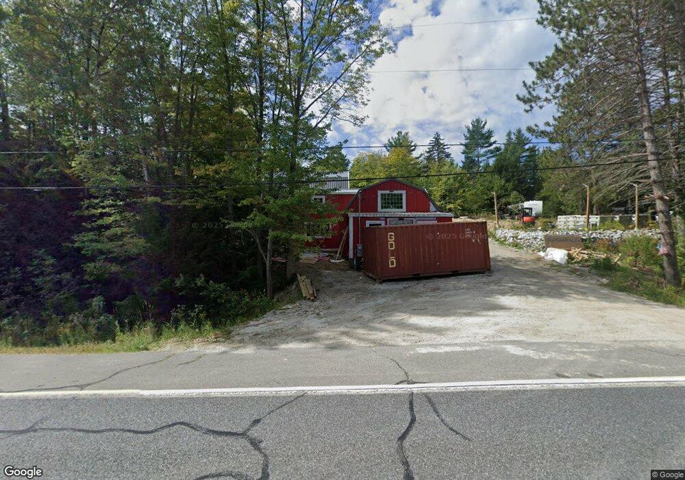
222 Us Route 2 W Wilton, ME 04294
Estimated Value: $161,700
2
Beds
1
Bath
1,072
Sq Ft
$151/Sq Ft
Est. Value
About This Home
This home is located at 222 Us Route 2 W, Wilton, ME 04294 and is currently priced at $161,700, approximately $150 per square foot. 222 Us Route 2 W is a home located in Franklin County with nearby schools including Mt. Blue High School and Western Maine Christian Academy.
Ownership History
Date
Name
Owned For
Owner Type
Purchase Details
Closed on
Jun 30, 2025
Sold by
222 Us Rt 2 Llc
Bought by
Cdoig Properties Llc
Current Estimated Value
Purchase Details
Closed on
Jun 9, 2025
Sold by
Tomlinson Designs Llc
Bought by
222 Us Rt 2 Llc
Purchase Details
Closed on
Dec 5, 2022
Sold by
Tomlinson Trevor D and Tomlinson Shauna R
Bought by
Wilson Lk Prop Mgmt & Hld
Purchase Details
Closed on
Sep 12, 2013
Sold by
Woods Gloria J and Lebarron Gloria J
Bought by
Woods Patricia E
Home Financials for this Owner
Home Financials are based on the most recent Mortgage that was taken out on this home.
Original Mortgage
$46,000
Interest Rate
4.43%
Mortgage Type
Commercial
Create a Home Valuation Report for This Property
The Home Valuation Report is an in-depth analysis detailing your home's value as well as a comparison with similar homes in the area
Home Values in the Area
Average Home Value in this Area
Purchase History
| Date | Buyer | Sale Price | Title Company |
|---|---|---|---|
| Cdoig Properties Llc | $40,000 | -- | |
| Cdoig Properties Llc | $40,000 | -- | |
| 222 Us Rt 2 Llc | $80,000 | None Available | |
| 222 Us Rt 2 Llc | $80,000 | None Available | |
| Wilson Lk Prop Mgmt & Hld | -- | None Available | |
| Wilson Lk Prop Mgmt & Hld | -- | None Available | |
| Woods Patricia E | -- | -- | |
| Woods Patricia E | -- | -- |
Source: Public Records
Mortgage History
| Date | Status | Borrower | Loan Amount |
|---|---|---|---|
| Previous Owner | Woods Patricia E | $46,000 |
Source: Public Records
Tax History Compared to Growth
Tax History
| Year | Tax Paid | Tax Assessment Tax Assessment Total Assessment is a certain percentage of the fair market value that is determined by local assessors to be the total taxable value of land and additions on the property. | Land | Improvement |
|---|---|---|---|---|
| 2024 | $3,689 | $173,207 | $47,500 | $125,707 |
| 2023 | $3,167 | $155,248 | $47,500 | $107,748 |
| 2022 | $2,090 | $107,746 | $47,500 | $60,246 |
| 2021 | $2,090 | $107,746 | $47,500 | $60,246 |
| 2020 | $2,155 | $107,746 | $47,500 | $60,246 |
| 2019 | $2,155 | $107,746 | $47,500 | $60,246 |
| 2018 | $2,193 | $107,746 | $47,500 | $60,246 |
| 2017 | $2,225 | $107,746 | $47,500 | $60,246 |
| 2016 | $2,225 | $107,746 | $47,500 | $60,246 |
| 2015 | $2,526 | $134,700 | $67,500 | $67,200 |
| 2014 | $2,337 | $134,700 | $67,500 | $67,200 |
| 2013 | $2,189 | $134,700 | $67,500 | $67,200 |
Source: Public Records
Map
Nearby Homes
- 55 Woodland Ave
- 2 Gilbert St S
- 42 Fernald St
- 5 Prospect St
- 2 Prospect St
- 15 Highland Ave
- 269 Weld Rd
- 60 Rolling Ridge
- 46 Webb Ave
- 122 Prospect St
- 1022 Main St
- M-25 L-006 Weld Rd
- 28//36&37 Us Route 2 & 4
- M16 L12 Maine 4
- 294 Depot St
- 1059 Main St
- 221 More Acres Rd
- Lots B&C Hanslip Rd
- 450 Old Jay Hill Rd
- 40 Bubier Rd