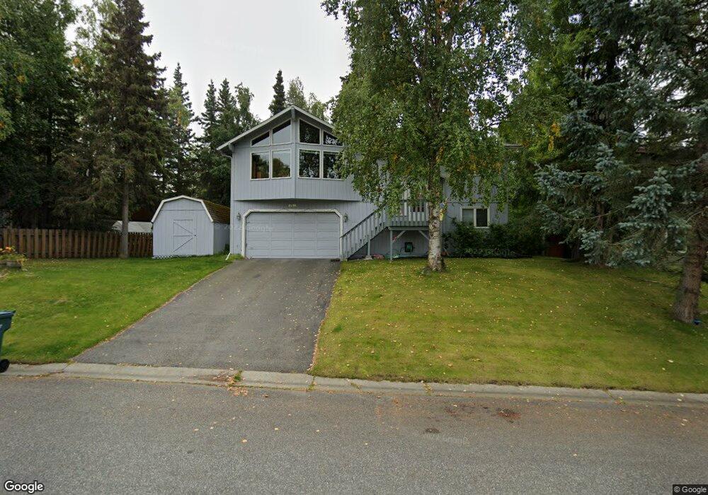
2220 Sues Way Anchorage, AK 99516
Huffman-O'Malley NeighborhoodEstimated Value: $393,000 - $521,000
3
Beds
3
Baths
2,052
Sq Ft
$231/Sq Ft
Est. Value
About This Home
This home is located at 2220 Sues Way, Anchorage, AK 99516 and is currently estimated at $473,727, approximately $230 per square foot. 2220 Sues Way is a home located in Anchorage Municipality with nearby schools including Rabbit Creek Elementary School, Goldenview Middle School, and South Anchorage High School.
Ownership History
Date
Name
Owned For
Owner Type
Purchase Details
Closed on
Mar 25, 2004
Sold by
Graves Rodney J
Bought by
Graves Rodney J and Graves Anne C
Current Estimated Value
Home Financials for this Owner
Home Financials are based on the most recent Mortgage that was taken out on this home.
Original Mortgage
$164,700
Interest Rate
5.57%
Mortgage Type
New Conventional
Purchase Details
Closed on
Jul 28, 1999
Sold by
Lee James C and Lee Janet B
Bought by
Graves Rodney J
Home Financials for this Owner
Home Financials are based on the most recent Mortgage that was taken out on this home.
Original Mortgage
$169,650
Interest Rate
7.64%
Mortgage Type
New Conventional
Purchase Details
Closed on
Sep 9, 1996
Sold by
Ayotte Stephen P and Ayotte Roberta L
Bought by
Lee James C and Lee Janet B
Home Financials for this Owner
Home Financials are based on the most recent Mortgage that was taken out on this home.
Original Mortgage
$84,000
Interest Rate
8.2%
Mortgage Type
New Conventional
Purchase Details
Closed on
Nov 16, 1994
Sold by
Higgins Michael J and Higgins Maria S
Bought by
Ayotte Stephen P and Ayotte Roberta L
Home Financials for this Owner
Home Financials are based on the most recent Mortgage that was taken out on this home.
Original Mortgage
$133,000
Interest Rate
8.91%
Mortgage Type
New Conventional
Purchase Details
Closed on
Aug 3, 1987
Sold by
Merrill Lynch Relo Mgmt Inc
Bought by
Higgins Michael J and Higgins Maria S
Home Financials for this Owner
Home Financials are based on the most recent Mortgage that was taken out on this home.
Original Mortgage
$137,339
Interest Rate
10.5%
Mortgage Type
FHA
Create a Home Valuation Report for This Property
The Home Valuation Report is an in-depth analysis detailing your home's value as well as a comparison with similar homes in the area
Home Values in the Area
Average Home Value in this Area
Purchase History
| Date | Buyer | Sale Price | Title Company |
|---|---|---|---|
| Graves Rodney J | -- | Stewart Title Of Alaska | |
| Graves Rodney J | -- | -- | |
| Lee James C | -- | -- | |
| Ayotte Stephen P | -- | -- | |
| Higgins Michael J | -- | -- |
Source: Public Records
Mortgage History
| Date | Status | Borrower | Loan Amount |
|---|---|---|---|
| Closed | Graves Rodney J | $164,700 | |
| Closed | Graves Rodney J | $169,650 | |
| Previous Owner | Lee James C | $84,000 | |
| Previous Owner | Ayotte Stephen P | $133,000 | |
| Previous Owner | Higgins Michael J | $137,339 |
Source: Public Records
Tax History Compared to Growth
Tax History
| Year | Tax Paid | Tax Assessment Tax Assessment Total Assessment is a certain percentage of the fair market value that is determined by local assessors to be the total taxable value of land and additions on the property. | Land | Improvement |
|---|---|---|---|---|
| 2025 | $3,195 | $448,000 | $116,200 | $331,800 |
| 2024 | $3,195 | $422,900 | $116,200 | $306,700 |
| 2023 | $6,684 | $392,500 | $116,200 | $276,300 |
| 2022 | $2,733 | $362,300 | $116,200 | $246,100 |
| 2021 | $6,237 | $346,100 | $116,200 | $229,900 |
| 2020 | $2,476 | $346,800 | $116,200 | $230,600 |
| 2019 | $2,339 | $343,000 | $116,200 | $226,800 |
| 2018 | $4,674 | $335,000 | $116,200 | $218,800 |
| 2017 | $4,936 | $335,200 | $116,200 | $219,000 |
| 2016 | $4,528 | $352,700 | $116,200 | $236,500 |
| 2015 | $4,528 | $335,300 | $116,200 | $219,100 |
| 2014 | $4,528 | $324,000 | $119,900 | $204,100 |
Source: Public Records
Map
Nearby Homes
- 2020 Steeple Dr
- 2701 Kempton Hills Dr
- 13105 Stephenson St
- 2048 Meander Dr
- 13530 Westwind Dr
- 13470 Baywind Cir
- 13322 Diggins Dr
- 1800 Hamilton Dr
- 13481 Baywind Dr
- 2000 Jarvis Ave
- 3040 Chesapeake Cir
- 2521 Winterchase Cir
- 12283 Timberwood Cir
- 13540 Seachant Cir
- 13351 Venus Way
- 13103 Brandon St Unit 14
- 3025 Huffman Rd
- 12241 Gander St
- 1677 Circlewood Dr
- 14121 Sunview Dr