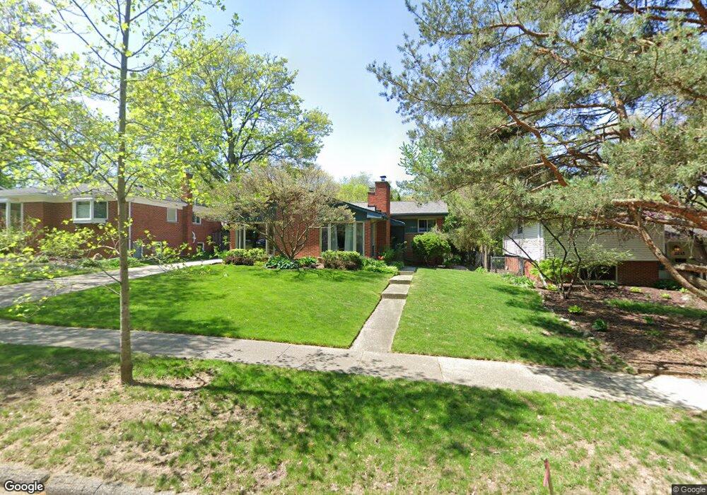
2225 Independence Blvd Ann Arbor, MI 48104
Allen NeighborhoodEstimated Value: $451,000 - $514,000
3
Beds
2
Baths
1,292
Sq Ft
$367/Sq Ft
Est. Value
About This Home
This home is located at 2225 Independence Blvd, Ann Arbor, MI 48104 and is currently estimated at $474,196, approximately $367 per square foot. 2225 Independence Blvd is a home located in Washtenaw County with nearby schools including Allen Elementary School, Tappan Middle School, and Pioneer High School.
Ownership History
Date
Name
Owned For
Owner Type
Purchase Details
Closed on
Apr 16, 2022
Sold by
Novar Francie L
Bought by
Novar Francie L
Current Estimated Value
Purchase Details
Closed on
Apr 18, 2008
Sold by
Colvin Peter and Colvin Nancy
Bought by
Novar Francie L
Home Financials for this Owner
Home Financials are based on the most recent Mortgage that was taken out on this home.
Original Mortgage
$148,000
Interest Rate
5.88%
Mortgage Type
Unknown
Create a Home Valuation Report for This Property
The Home Valuation Report is an in-depth analysis detailing your home's value as well as a comparison with similar homes in the area
Home Values in the Area
Average Home Value in this Area
Purchase History
| Date | Buyer | Sale Price | Title Company |
|---|---|---|---|
| Novar Francie L | -- | Land Title | |
| Novar Francie L | $185,000 | Sst |
Source: Public Records
Mortgage History
| Date | Status | Borrower | Loan Amount |
|---|---|---|---|
| Previous Owner | Novar Francie L | $148,000 |
Source: Public Records
Tax History Compared to Growth
Tax History
| Year | Tax Paid | Tax Assessment Tax Assessment Total Assessment is a certain percentage of the fair market value that is determined by local assessors to be the total taxable value of land and additions on the property. | Land | Improvement |
|---|---|---|---|---|
| 2025 | $5,172 | $206,100 | $0 | $0 |
| 2024 | $4,816 | $183,600 | $0 | $0 |
| 2023 | $4,440 | $171,400 | $0 | $0 |
| 2022 | $4,839 | $155,300 | $0 | $0 |
| 2021 | $4,725 | $148,600 | $0 | $0 |
| 2020 | $4,629 | $140,000 | $0 | $0 |
| 2019 | $4,406 | $129,600 | $129,600 | $0 |
| 2018 | $4,953 | $116,600 | $0 | $0 |
| 2017 | $5,365 | $114,300 | $0 | $0 |
| 2016 | $4,175 | $84,495 | $0 | $0 |
| 2015 | $3,882 | $84,243 | $0 | $0 |
| 2014 | $3,882 | $81,612 | $0 | $0 |
| 2013 | -- | $81,612 | $0 | $0 |
Source: Public Records
Map
Nearby Homes
- 2219 Needham Rd
- 2510 Manchester Rd
- 2236 Medford Rd
- 2106 Camelot Rd
- 2125 Nature Cove Ct Unit 108
- 2115 Nature Cove Ct Unit 103
- 2115 Nature Cove Ct Unit 206
- 2941 Kimberley Rd
- 2931 Kimberley Rd
- 2112 Carhart Ave
- 2731 Canterbury Rd
- 2434 Mulberry Ct Unit 22A
- 2403 Packard St Unit 38D
- 2211 Ferdon Rd
- 2107 Ferdon Rd
- 2831 Canterbury Rd
- 1864 Arlington Blvd
- 2965 Kimberley Rd
- 2237 Trillium Ln
- 2316 Brockman Blvd
- 2233 Independence Blvd
- 2217 Independence Blvd
- 2241 Independence Blvd
- 2295 Manchester Rd
- 2281 Manchester Rd
- 2287 Manchester Rd
- 2232 Independence Blvd
- 2273 Manchester Rd
- 2249 Independence Blvd
- 2259 Manchester Rd
- 2240 Independence Blvd
- 2224 Independence Blvd
- 2203 Independence Blvd
- 2263 Manchester Rd
- 2248 Independence Blvd
- 2216 Independence Blvd
- 2257 Independence Blvd
- 2301 Manchester Rd
- 2251 Manchester Rd
- 2307 Manchester Rd