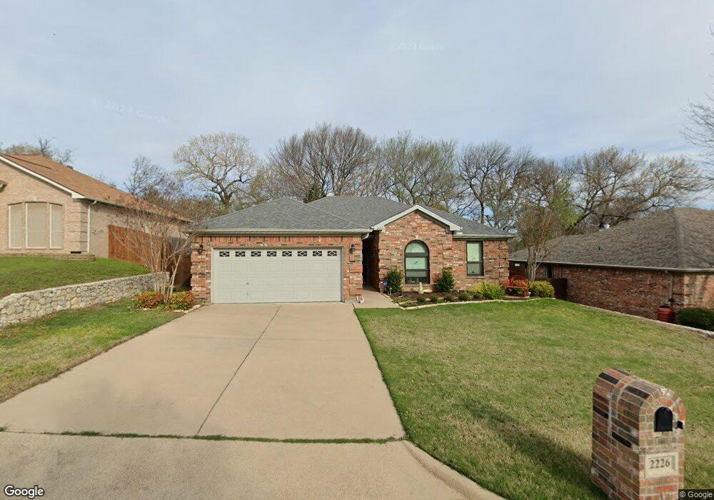
2226 Summer Brook Dr Weatherford, TX 76087
Estimated Value: $313,340 - $340,000
3
Beds
2
Baths
1,700
Sq Ft
$196/Sq Ft
Est. Value
About This Home
This home is located at 2226 Summer Brook Dr, Weatherford, TX 76087 and is currently estimated at $332,835, approximately $195 per square foot. 2226 Summer Brook Dr is a home located in Parker County with nearby schools including Austin Elementary School, Hall Middle School, and Weatherford High School.
Ownership History
Date
Name
Owned For
Owner Type
Purchase Details
Closed on
Oct 30, 2014
Sold by
King Phillip
Bought by
Wester Nancy Lynn
Current Estimated Value
Purchase Details
Closed on
Jun 7, 2010
Sold by
Cooksey David G and Cooksey Linda
Bought by
Wester Nancy L
Home Financials for this Owner
Home Financials are based on the most recent Mortgage that was taken out on this home.
Original Mortgage
$138,632
Interest Rate
4.87%
Mortgage Type
FHA
Purchase Details
Closed on
May 28, 2005
Sold by
Choice Homes Inc
Bought by
Cooksey David Gill and Cooksey Linda
Home Financials for this Owner
Home Financials are based on the most recent Mortgage that was taken out on this home.
Original Mortgage
$105,769
Interest Rate
5.39%
Mortgage Type
Stand Alone Second
Purchase Details
Closed on
Mar 26, 2005
Sold by
Ssm Investments Inc
Bought by
Wester Nancy L
Create a Home Valuation Report for This Property
The Home Valuation Report is an in-depth analysis detailing your home's value as well as a comparison with similar homes in the area
Home Values in the Area
Average Home Value in this Area
Purchase History
| Date | Buyer | Sale Price | Title Company |
|---|---|---|---|
| Wester Nancy Lynn | -- | None Available | |
| Wester Nancy L | -- | -- | |
| King Phillip | -- | None Available | |
| Cooksey David Gill | -- | Alamo Title Company | |
| Wester Nancy L | -- | -- |
Source: Public Records
Mortgage History
| Date | Status | Borrower | Loan Amount |
|---|---|---|---|
| Previous Owner | King Phillip | $138,632 | |
| Previous Owner | Cooksey David Gill | $105,769 | |
| Previous Owner | Cooksey David Gill | $105,288 |
Source: Public Records
Tax History Compared to Growth
Tax History
| Year | Tax Paid | Tax Assessment Tax Assessment Total Assessment is a certain percentage of the fair market value that is determined by local assessors to be the total taxable value of land and additions on the property. | Land | Improvement |
|---|---|---|---|---|
| 2025 | $3,123 | $309,397 | -- | -- |
| 2024 | $3,123 | $281,270 | -- | -- |
| 2023 | $3,123 | $255,700 | $0 | $0 |
| 2022 | $5,156 | $232,460 | $30,000 | $202,460 |
| 2021 | $5,186 | $232,460 | $30,000 | $202,460 |
| 2020 | $4,743 | $196,310 | $30,000 | $166,310 |
| 2019 | $4,803 | $196,310 | $30,000 | $166,310 |
| 2018 | $4,385 | $170,970 | $30,000 | $140,970 |
| 2017 | $4,459 | $170,970 | $30,000 | $140,970 |
| 2016 | $4,054 | $154,060 | $30,000 | $124,060 |
| 2015 | $3,970 | $154,060 | $30,000 | $124,060 |
| 2014 | $3,505 | $147,920 | $30,000 | $117,920 |
Source: Public Records
Map
Nearby Homes
- 2113 Country Brook Dr
- 104 Carriage Hill Ct
- 2020 Maplewood Dr
- 2102 Clear Creek Dr
- 344 Clear Lake Ln
- 115 Autumn Springs Ct
- 1910 Maplewood Dr
- 221 Arapahoe Ridge
- 2904 E Bankhead Hwy
- 1905 Clear Creek Dr
- 2218 Lake Country Dr
- 2116 Clear Lake Rd
- 2214 Lake Country Dr
- 2202 Lakeforest Dr
- 105 Country Green Ct
- 2001 Santa fe Dr
- 128 Black Forest Dr
- 118 Black Forest Dr
- 101 Black Forest Dr
- 1421 Highlake Ln
- 2222 Summer Brook Dr
- 2218 Summer Brook Dr
- 2234 Summer Brook Dr
- 2205 Country Brook Dr
- 2201 Country Brook Dr
- 2209 Country Brook Dr
- 2221 Summer Brook Dr
- 2225 Summer Brook Dr
- 2217 Summer Brook Dr
- 2214 Summer Brook Dr
- 2229 Summer Brook Dr
- 2213 Country Brook Dr
- 2213 Summer Brook Dr
- 2210 Summer Brook Dr
- 2145 Country Brook Dr
- 2302 Summer Brook Dr
- 2209 Summer Brook Dr
- 2226 Creek Side Dr
- 2301 Summer Brook Dr
- 2222 Creek Side Dr