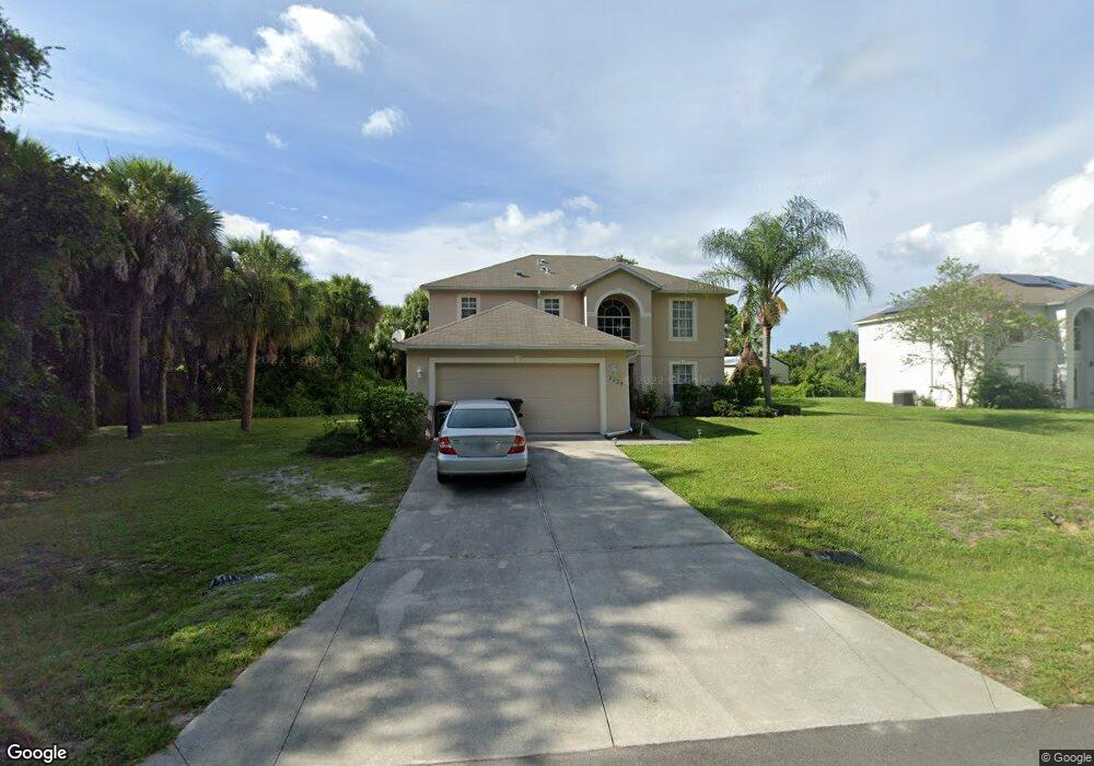
2228 Alliance Ave North Port, FL 34286
Estimated Value: $283,000 - $380,000
4
Beds
3
Baths
2,248
Sq Ft
$146/Sq Ft
Est. Value
About This Home
This home is located at 2228 Alliance Ave, North Port, FL 34286 and is currently estimated at $329,321, approximately $146 per square foot. 2228 Alliance Ave is a home located in Sarasota County with nearby schools including Toledo Blade Elementary School, North Port High School, and Woodland Middle School.
Ownership History
Date
Name
Owned For
Owner Type
Purchase Details
Closed on
Sep 20, 2007
Sold by
Stanford Ray A
Bought by
Gonzalez Manrique and Gonzalez Yavnim
Current Estimated Value
Home Financials for this Owner
Home Financials are based on the most recent Mortgage that was taken out on this home.
Original Mortgage
$155,120
Outstanding Balance
$97,661
Interest Rate
6.55%
Mortgage Type
Purchase Money Mortgage
Estimated Equity
$231,660
Purchase Details
Closed on
May 23, 2007
Sold by
Maronda Homes Inc Of Florida
Bought by
Stanford Ray A
Purchase Details
Closed on
Nov 26, 2003
Sold by
Boone Joseph A
Bought by
Maronda Homes Inc Fl
Create a Home Valuation Report for This Property
The Home Valuation Report is an in-depth analysis detailing your home's value as well as a comparison with similar homes in the area
Home Values in the Area
Average Home Value in this Area
Purchase History
| Date | Buyer | Sale Price | Title Company |
|---|---|---|---|
| Gonzalez Manrique | $193,900 | Chelsea Title Company | |
| Stanford Ray A | $164,200 | Attorney | |
| Maronda Homes Inc Fl | $7,000 | -- | |
| Maronda Homes Inc Fl | $7,000 | -- |
Source: Public Records
Mortgage History
| Date | Status | Borrower | Loan Amount |
|---|---|---|---|
| Open | Gonzalez Manrique | $155,120 |
Source: Public Records
Tax History Compared to Growth
Tax History
| Year | Tax Paid | Tax Assessment Tax Assessment Total Assessment is a certain percentage of the fair market value that is determined by local assessors to be the total taxable value of land and additions on the property. | Land | Improvement |
|---|---|---|---|---|
| 2024 | $1,686 | $100,660 | -- | -- |
| 2023 | $1,686 | $97,728 | $0 | $0 |
| 2022 | $1,788 | $104,482 | $0 | $0 |
| 2021 | $1,740 | $101,439 | $0 | $0 |
| 2020 | $1,701 | $100,038 | $0 | $0 |
| 2019 | $1,649 | $97,789 | $0 | $0 |
| 2018 | $1,522 | $95,966 | $0 | $0 |
| 2017 | $1,484 | $93,992 | $0 | $0 |
| 2016 | $1,466 | $153,500 | $5,000 | $148,500 |
| 2015 | $1,474 | $129,100 | $4,500 | $124,600 |
| 2014 | $1,450 | $89,353 | $0 | $0 |
Source: Public Records
Map
Nearby Homes
- 2031 Baltimore St
- 2111 Baltimore St
- 0 Ann Arbor Rd Unit A4520722
- 2551 Alhaven Terrace
- Lot 5 Alhaven Terrace
- Lot 32 Baltimore St
- 0 Snover Ave
- 0 Yacolt Ave Unit MFRA4665223
- 2657 Tusket Ave
- 0 Wyola Ave Unit MFRC7507151
- 1956 Snover Ave
- 0 Circleville St Unit MFRC7506886
- 0 Circleville St Unit MFRC7492644
- 0 Circleville St Unit MFRC7492646
- 2468 Burlington St
- LOT 45 Burlington St
- LOT 44 Burlington St
- 2267 Cincinnati St
- 1372 Vendome Terrace
- 0 Alhaven Terrace Unit MFRN6130985
- 2212 Alliance Ave
- 2289 Altitude Ave
- 2229 Alliance Ave
- 2198 Alliance Ave
- Baltimore St
- Baltimore St
- Baltimore St
- Baltimore St
- Baltimore
- 2213 Alliance Ave
- 2257 Alliance Ave
- 2177 Altitude Ave
- 2063 Baltimore St
- 2079 Baltimore St
- 2282 Altitude Ave
- Altitude Ave
- Altitude Ave
- Altitude Ave
- 2187 Alliance Ave
- 2031 Baltimore St Unit n/a