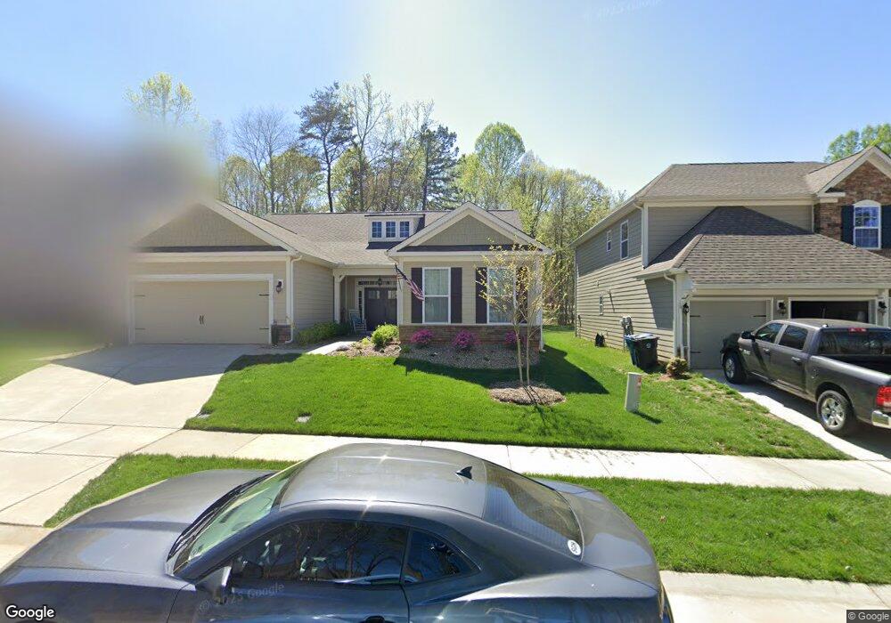
223 Blueview Rd Unit 68 Mooresville, NC 28117
Estimated Value: $477,536 - $571,000
3
Beds
3
Baths
2,234
Sq Ft
$233/Sq Ft
Est. Value
About This Home
This home is located at 223 Blueview Rd Unit 68, Mooresville, NC 28117 and is currently estimated at $520,134, approximately $232 per square foot. 223 Blueview Rd Unit 68 is a home located in Iredell County with nearby schools including Lakeshore Elementary School, Lakeshore Middle School, and Lake Norman High School.
Ownership History
Date
Name
Owned For
Owner Type
Purchase Details
Closed on
May 27, 2022
Sold by
Kenter David A and Kenter Eileen G
Bought by
Ricardo Menditto Revocable Trust
Current Estimated Value
Purchase Details
Closed on
Jul 19, 2017
Sold by
D R Horton Inc
Bought by
Kenter David A and Kenter Eileen G
Home Financials for this Owner
Home Financials are based on the most recent Mortgage that was taken out on this home.
Original Mortgage
$190,000
Interest Rate
3.89%
Mortgage Type
New Conventional
Create a Home Valuation Report for This Property
The Home Valuation Report is an in-depth analysis detailing your home's value as well as a comparison with similar homes in the area
Home Values in the Area
Average Home Value in this Area
Purchase History
| Date | Buyer | Sale Price | Title Company |
|---|---|---|---|
| Ricardo Menditto Revocable Trust | $450,000 | Dudley L Ragan | |
| Kenter David A | $320,000 | None Available |
Source: Public Records
Mortgage History
| Date | Status | Borrower | Loan Amount |
|---|---|---|---|
| Previous Owner | Kenter David A | $190,000 |
Source: Public Records
Tax History Compared to Growth
Tax History
| Year | Tax Paid | Tax Assessment Tax Assessment Total Assessment is a certain percentage of the fair market value that is determined by local assessors to be the total taxable value of land and additions on the property. | Land | Improvement |
|---|---|---|---|---|
| 2024 | $4,905 | $471,860 | $90,000 | $381,860 |
| 2023 | $4,345 | $471,860 | $90,000 | $381,860 |
| 2022 | $3,592 | $305,330 | $62,000 | $243,330 |
| 2021 | $3,588 | $305,330 | $62,000 | $243,330 |
| 2020 | $3,588 | $305,330 | $62,000 | $243,330 |
| 2019 | $3,558 | $305,330 | $62,000 | $243,330 |
| 2018 | $3,378 | $289,510 | $60,000 | $229,510 |
| 2017 | $777 | $264,920 | $60,000 | $204,920 |
Source: Public Records
Map
Nearby Homes
- 142 Canoe Pole Ln
- 131 Canoe Pole Ln
- 208 Canoe Pole Ln
- 148 Twin Sisters Ln
- 194 Hanks Bluff Dr
- 110 Hunts Landing Dr
- 127 Palos Verde Dr
- 125 Cherokee Dr
- 124 Cedar Woods Dr
- 000 Bluefield Rd
- 107 Rosebay Dr
- 796 Cornelius Rd
- 117 Blackbeard Ln
- 107 Blackbeard Ln Unit 2
- 148 Castle Dr
- 456 Cornelius Rd
- 110 Dorothy Ln
- 903 Cornelius Rd
- 0000 Dorothy Ln
- 128 Carolina Ash Ln
- 225 Blueview Rd Unit 69
- 221 Blueview Rd Unit 67
- 221 Blueview Rd
- 219 Blueview Rd
- 219 Blueview Rd Unit 66
- 217 Blueview Rd Unit 65
- 217 Blueview Rd
- 215 Blarney Rd Unit 64
- 215 Blueview Rd
- 165 Canoe Pole Ln Unit 100
- 161 Canoe Pole Ln Unit 101
- 213 Blueview Rd
- 213 Blarney Rd Unit 63
- 157 Canoe Pole Ln Unit 102
- 237 Blueview Rd Unit 70
- 237 Blueview Rd
- 798 Big Indian Loop
- 788 Big Indian Loop
- 211 Blueview Rd
- 211 Blarney Rd Unit 62