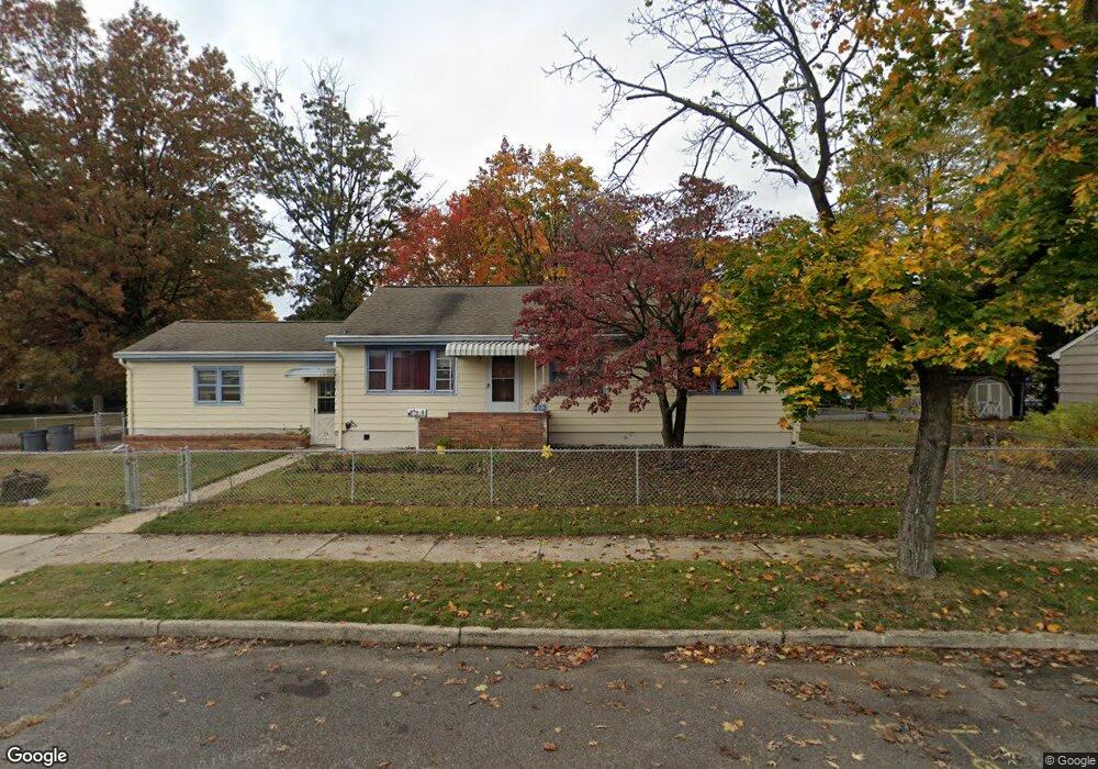
223 Samdin Blvd Trenton, NJ 08610
Estimated Value: $325,000 - $375,149
--
Bed
--
Bath
1,032
Sq Ft
$337/Sq Ft
Est. Value
About This Home
This home is located at 223 Samdin Blvd, Trenton, NJ 08610 and is currently estimated at $347,537, approximately $336 per square foot. 223 Samdin Blvd is a home located in Mercer County with nearby schools including George E. Wilson Elementary School, Albert E. Grice Middle School, and Hamilton West-Watson High School.
Ownership History
Date
Name
Owned For
Owner Type
Purchase Details
Closed on
Aug 15, 2005
Sold by
Clendening Robert
Bought by
Orozco Concepcion and Orozco Melquiades
Current Estimated Value
Home Financials for this Owner
Home Financials are based on the most recent Mortgage that was taken out on this home.
Original Mortgage
$204,000
Outstanding Balance
$108,195
Interest Rate
5.81%
Mortgage Type
Purchase Money Mortgage
Estimated Equity
$239,342
Purchase Details
Closed on
Nov 6, 1998
Sold by
Panebianco Barbara
Bought by
Clendening Robert and Clendening Marie
Home Financials for this Owner
Home Financials are based on the most recent Mortgage that was taken out on this home.
Original Mortgage
$60,000
Interest Rate
6.65%
Mortgage Type
Purchase Money Mortgage
Create a Home Valuation Report for This Property
The Home Valuation Report is an in-depth analysis detailing your home's value as well as a comparison with similar homes in the area
Home Values in the Area
Average Home Value in this Area
Purchase History
| Date | Buyer | Sale Price | Title Company |
|---|---|---|---|
| Orozco Concepcion | $255,000 | -- | |
| Clendening Robert | $110,000 | -- |
Source: Public Records
Mortgage History
| Date | Status | Borrower | Loan Amount |
|---|---|---|---|
| Open | Orozco Concepcion | $204,000 | |
| Previous Owner | Clendening Robert | $60,000 |
Source: Public Records
Tax History Compared to Growth
Tax History
| Year | Tax Paid | Tax Assessment Tax Assessment Total Assessment is a certain percentage of the fair market value that is determined by local assessors to be the total taxable value of land and additions on the property. | Land | Improvement |
|---|---|---|---|---|
| 2025 | $6,015 | $170,700 | $60,200 | $110,500 |
| 2024 | $5,638 | $170,700 | $60,200 | $110,500 |
| 2023 | $5,638 | $170,700 | $60,200 | $110,500 |
| 2022 | $5,549 | $170,700 | $60,200 | $110,500 |
| 2021 | $6,884 | $170,700 | $60,200 | $110,500 |
| 2020 | $6,270 | $170,700 | $60,200 | $110,500 |
| 2019 | $6,085 | $170,700 | $60,200 | $110,500 |
| 2018 | $6,039 | $170,700 | $60,200 | $110,500 |
| 2017 | $5,722 | $170,700 | $60,200 | $110,500 |
| 2016 | $4,616 | $170,700 | $60,200 | $110,500 |
| 2015 | $5,904 | $112,900 | $45,400 | $67,500 |
| 2014 | $5,782 | $112,900 | $45,400 | $67,500 |
Source: Public Records
Map
Nearby Homes
- 164 Lillian Ave
- 118 Hunter Ave
- 109 E Park Ave
- 252 Churchill Ave
- 158 Churchill Ave
- 234 Thropp Ave
- 204 Thropp Ave
- 2033 Genesee St
- 949 Schiller Ave
- 624 Hunt Ave
- 429 Wilfred Ave
- 28 Thropp Ave
- 533 Hunt Ave
- 156 Maddock Ave
- 408 Berg Ave
- 529 Hunt Ave
- 316 W Park Ave
- 323 Wilfred Ave
- 1961 S Broad St
- 436 Hunt Ave
- 0 Exton Ave
- 215 Ruth Ave
- 237 Samdin Blvd
- 216 Samdin Blvd
- 203 Ruth Ave
- 210 Samdin Blvd
- 222 Samdin Blvd
- 225 Ruth Ave
- 204 Samdin Blvd
- 226 Samdin Blvd
- 229 Ruth Ave
- 243 Samdin Blvd
- 232 Samdin Blvd
- 238 Samdin Blvd
- 167 Samdin Blvd
- 245 Ruth Ave
- 249 Samdin Blvd
- 166 Samdin Blvd
- 205 Lillian Ave
- 207 Lillian Ave