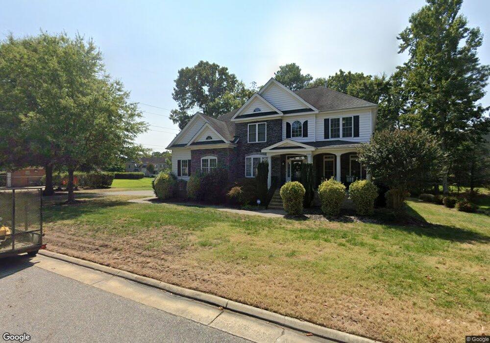
22300 Northgate Dr Carrollton, VA 23314
Estimated Value: $513,000 - $572,513
5
Beds
4
Baths
3,300
Sq Ft
$165/Sq Ft
Est. Value
About This Home
This home is located at 22300 Northgate Dr, Carrollton, VA 23314 and is currently estimated at $544,628, approximately $165 per square foot. 22300 Northgate Dr is a home located in Isle of Wight County with nearby schools including Carrollton Elementary School, Smithfield Middle School, and Smithfield High School.
Ownership History
Date
Name
Owned For
Owner Type
Purchase Details
Closed on
Mar 15, 2023
Sold by
Mack Ronnie L and Mack Shona M
Bought by
Robertson Kimberly A and Robertson Anthony Q
Current Estimated Value
Home Financials for this Owner
Home Financials are based on the most recent Mortgage that was taken out on this home.
Original Mortgage
$438,048
Outstanding Balance
$424,197
Interest Rate
6.09%
Mortgage Type
VA
Estimated Equity
$120,431
Purchase Details
Closed on
Apr 14, 2014
Purchase Details
Closed on
Jun 19, 2007
Purchase Details
Closed on
Dec 9, 2005
Create a Home Valuation Report for This Property
The Home Valuation Report is an in-depth analysis detailing your home's value as well as a comparison with similar homes in the area
Home Values in the Area
Average Home Value in this Area
Purchase History
| Date | Buyer | Sale Price | Title Company |
|---|---|---|---|
| Robertson Kimberly A | $480,000 | Westcor Land Title | |
| -- | $389,000 | -- | |
| -- | $557,400 | -- | |
| -- | $685,500 | -- |
Source: Public Records
Mortgage History
| Date | Status | Borrower | Loan Amount |
|---|---|---|---|
| Open | Robertson Kimberly A | $438,048 |
Source: Public Records
Tax History Compared to Growth
Tax History
| Year | Tax Paid | Tax Assessment Tax Assessment Total Assessment is a certain percentage of the fair market value that is determined by local assessors to be the total taxable value of land and additions on the property. | Land | Improvement |
|---|---|---|---|---|
| 2025 | $3,838 | $495,200 | $85,000 | $410,200 |
| 2024 | $3,615 | $495,200 | $85,000 | $410,200 |
| 2023 | $3,570 | $495,200 | $85,000 | $410,200 |
| 2022 | $3,627 | $420,300 | $85,000 | $335,300 |
| 2021 | $3,627 | $420,300 | $85,000 | $335,300 |
| 2020 | $3,627 | $420,300 | $85,000 | $335,300 |
| 2019 | $3,627 | $420,300 | $85,000 | $335,300 |
| 2018 | $3,568 | $413,400 | $85,000 | $328,400 |
| 2016 | $3,586 | $413,400 | $85,000 | $328,400 |
| 2015 | $3,800 | $413,400 | $85,000 | $328,400 |
| 2014 | $3,800 | $438,600 | $105,000 | $333,600 |
| 2013 | -- | $438,600 | $105,000 | $333,600 |
Source: Public Records
Map
Nearby Homes
- 1105 Rivers Arch
- 1002 Rivers Arch
- 902 Rivers Arch
- 1509 Broad Water Arch
- 301 Blue Heron Trail
- 410 Marsh Hawk Trail
- 2002 James River Trail
- 13554 S Village Way
- Palladio 2 Story Plan at South Harbor - Single-Family 55 Plus
- Bramante 2 Story Plan at South Harbor - Single-Family 55 Plus
- Palladio Ranch Plan at South Harbor - Single-Family 55 Plus
- 13559 S Village Way
- 3.42AC Smiths Neck Rd
- Caroline Plan at South Harbor - Towns 55 Plus
- 22346 Tradewinds Dr
- 23088 Preserve Place
- 13435 Prince Andrew Trail
- 13418 Bentley Heath Way Unit 97
- 13436 Prince Andrew Trail
- 13447 Bentley Heath Way
- 22308 Northgate Dr
- 22290 Northgate Dr
- 13460 Ahsley Park Ct
- 13460 Ashley Park Ct
- 22305 Northgate Dr
- 22297 Northgate Dr
- 13468 Ashley Park Ct
- 22313 Northgate Dr
- 13483 Ashley Park Ct
- 22289 Northgate Dr
- 1104 Rivers Arch
- 1103 Rivers Arch
- 1106 Rivers Arch
- 13461 Ashley Park Ct
- 22316 Northgate Dr
- 1006 Rivers Arch
- 13453 Ashley Park Ct
- 1102 Rivers Arch
- 13476 Ashley Park Ct
- 1107 Rivers Arch