Estimated Value: $552,316 - $621,000
3
Beds
3
Baths
1,930
Sq Ft
$308/Sq Ft
Est. Value
About This Home
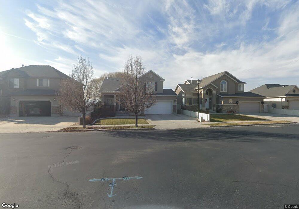
This home is located at 2233 N 2600 W, Lehi, UT 84043 and is currently estimated at $594,579, approximately $308 per square foot. 2233 N 2600 W is a home located in Utah County with nearby schools including Liberty Hills Elementary School, Skyridge High School, and Ascent Academies of Utah - Lehi Campus.
Ownership History
Date
Name
Owned For
Owner Type
Purchase Details
Closed on
Jan 3, 2008
Sold by
Ivory Homes Ltd
Bought by
Collette Brandon B and Collette Hillary B
Current Estimated Value
Home Financials for this Owner
Home Financials are based on the most recent Mortgage that was taken out on this home.
Original Mortgage
$231,143
Outstanding Balance
$145,826
Interest Rate
6.15%
Mortgage Type
Purchase Money Mortgage
Estimated Equity
$448,753
Create a Home Valuation Report for This Property
The Home Valuation Report is an in-depth analysis detailing your home's value as well as a comparison with similar homes in the area
Home Values in the Area
Average Home Value in this Area
Purchase History
| Date | Buyer | Sale Price | Title Company |
|---|---|---|---|
| Collette Brandon B | -- | Cottonwood Title | |
| Ivory Homes Ltd | -- | Cottonwood Title |
Source: Public Records
Mortgage History
| Date | Status | Borrower | Loan Amount |
|---|---|---|---|
| Open | Collette Brandon B | $231,143 |
Source: Public Records
Tax History Compared to Growth
Tax History
| Year | Tax Paid | Tax Assessment Tax Assessment Total Assessment is a certain percentage of the fair market value that is determined by local assessors to be the total taxable value of land and additions on the property. | Land | Improvement |
|---|---|---|---|---|
| 2025 | $2,293 | $280,170 | $202,800 | $306,600 |
| 2024 | $2,293 | $268,400 | $0 | $0 |
| 2023 | $2,180 | $277,035 | $0 | $0 |
| 2022 | $2,330 | $287,045 | $0 | $0 |
| 2021 | $2,093 | $389,700 | $117,400 | $272,300 |
| 2020 | $1,973 | $363,200 | $108,700 | $254,500 |
| 2019 | $1,816 | $347,500 | $108,700 | $238,800 |
| 2018 | $1,737 | $314,200 | $102,500 | $211,700 |
| 2017 | $1,706 | $164,120 | $0 | $0 |
| 2016 | $1,744 | $155,595 | $0 | $0 |
| 2015 | $1,634 | $138,380 | $0 | $0 |
| 2014 | $1,587 | $133,650 | $0 | $0 |
Source: Public Records
Map
Nearby Homes
- 2189 N 2600 W
- 2464 W 2250 N
- 2196 N 2350 W
- Huntington Plan at Pioneer Meadows
- Silver Lake Plan at Pioneer Meadows
- Summit Plan at Pioneer Meadows
- Palisade Plan at Pioneer Meadows
- 1968 N 2040 W Unit 40
- 1969 N 2040 St W
- 2013 N 2040 W
- 1990 N 2040 W
- 1990 N 2040 W Unit 41
- 1970 N 2090 St W
- 1854 N 2230 W
- 2419 N 3130 W
- 1842 N 2230 W
- 1870 N 2230 W
- 1870 N 2230 W Unit 23
- 1896 N 2230 W
- 1908 N 2230 W