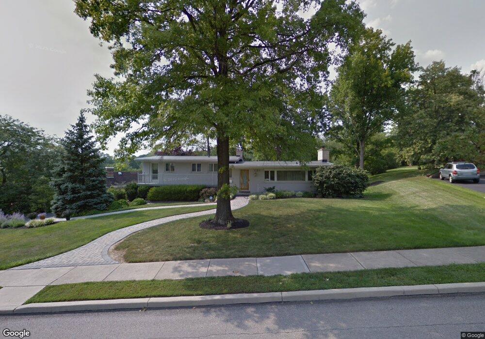
2234 Raeburn Dr Cincinnati, OH 45223
Mount Airy NeighborhoodEstimated Value: $324,000 - $344,544
3
Beds
2
Baths
1,582
Sq Ft
$210/Sq Ft
Est. Value
About This Home
This home is located at 2234 Raeburn Dr, Cincinnati, OH 45223 and is currently estimated at $331,886, approximately $209 per square foot. 2234 Raeburn Dr is a home located in Hamilton County with nearby schools including Chase Elementary School, Robert A. Taft Information Technology High School, and Western Hills High School.
Ownership History
Date
Name
Owned For
Owner Type
Purchase Details
Closed on
Jul 30, 2025
Sold by
Deborah Lynn Bertsch Trust and Jeffrey Albrinck J
Bought by
Bertsch Margaret
Current Estimated Value
Purchase Details
Closed on
Oct 27, 1992
Sold by
Bertsch Deborah Lynn
Bought by
Bertsch Deborah Lynn
Create a Home Valuation Report for This Property
The Home Valuation Report is an in-depth analysis detailing your home's value as well as a comparison with similar homes in the area
Home Values in the Area
Average Home Value in this Area
Purchase History
| Date | Buyer | Sale Price | Title Company |
|---|---|---|---|
| Bertsch Margaret | -- | None Listed On Document | |
| Bertsch Deborah Lynn | $142,500 | -- |
Source: Public Records
Tax History Compared to Growth
Tax History
| Year | Tax Paid | Tax Assessment Tax Assessment Total Assessment is a certain percentage of the fair market value that is determined by local assessors to be the total taxable value of land and additions on the property. | Land | Improvement |
|---|---|---|---|---|
| 2024 | $6,244 | $104,143 | $17,682 | $86,461 |
| 2023 | $6,384 | $104,143 | $17,682 | $86,461 |
| 2022 | $5,047 | $73,735 | $21,571 | $52,164 |
| 2021 | $4,849 | $73,735 | $21,571 | $52,164 |
| 2020 | $4,991 | $73,735 | $21,571 | $52,164 |
| 2019 | $4,473 | $60,438 | $17,682 | $42,756 |
| 2018 | $4,480 | $60,438 | $17,682 | $42,756 |
| 2017 | $4,255 | $60,438 | $17,682 | $42,756 |
| 2016 | $4,361 | $61,079 | $18,732 | $42,347 |
| 2015 | $3,933 | $61,079 | $18,732 | $42,347 |
| 2014 | $3,961 | $61,079 | $18,732 | $42,347 |
| 2013 | $3,446 | $52,203 | $16,009 | $36,194 |
Source: Public Records
Map
Nearby Homes
- 4805 Chapel Ridge Dr
- 2088 Raeburn Dr
- 5425 Kirby Ave
- 1971 Kentucky Ave
- 4650 Kirby Ave
- 1723 Monterey Ct
- 1943 Chase Ave
- 4574 Kirby Ave
- 4636 Ashtree Dr
- 4361 Virginia Ave
- 4361 Badgeley St
- 4307 Hays Ave
- 4339 Kirby Ave
- 1722 Glen Parker Ave
- 4411 Colerain Ave
- 4223 Virginia Ave
- 1910 Chase Ave
- 4348 Kirby Ave
- 4050 Colerain Ave
- 4344 Kirby Ave
- 2240 Raeburn Dr
- 4905 N Raeburn Dr
- 2302 Raeburn Terrace
- 4913 N Raeburn Dr
- 2223 Raeburn Dr
- 2219 Raeburn Dr
- 2306 Raeburn Terrace
- 2241 Raeburn Dr
- 4921 N Raeburn Dr
- 4844 Raeburn Ln
- 2215 Raeburn Dr
- 2303 Raeburn Terrace
- 4906 N Raeburn Dr
- 4837 Raeburn Ln
- 4838 Raeburn Ln
- 4920 N Raeburn Dr
- 4805 S Raeburn Dr
- 2207 Raeburn Dr
- 2310 Raeburn Terrace
- 4929 N Raeburn Dr