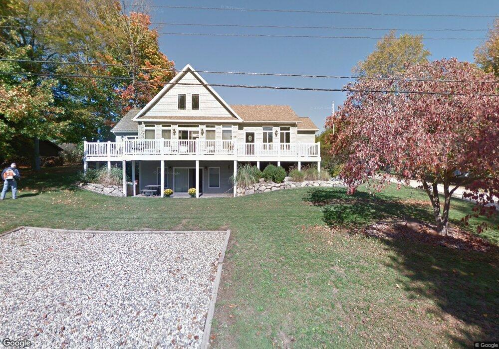
22382 Maple Row St Cassopolis, MI 49031
Estimated Value: $305,000 - $424,000
2
Beds
4
Baths
1,692
Sq Ft
$221/Sq Ft
Est. Value
About This Home
This home is located at 22382 Maple Row St, Cassopolis, MI 49031 and is currently estimated at $373,117, approximately $220 per square foot. 22382 Maple Row St is a home located in Cass County with nearby schools including Sam Adams Elementary School, Cassopolis Middle School, and Cassopolis Ross Beatty High School.
Ownership History
Date
Name
Owned For
Owner Type
Purchase Details
Closed on
Sep 17, 2020
Sold by
Jensik Viola
Bought by
Smith Debra A and Deeds Denise C
Current Estimated Value
Purchase Details
Closed on
Oct 22, 2018
Sold by
Wilkerson Robert and Wilkerson Jeanne C
Bought by
Jensik Viola
Purchase Details
Closed on
Aug 26, 2004
Sold by
Baker John F and Baker Alice N
Bought by
Wilkerson Robert and Wilkerson Jeanne C
Create a Home Valuation Report for This Property
The Home Valuation Report is an in-depth analysis detailing your home's value as well as a comparison with similar homes in the area
Purchase History
| Date | Buyer | Sale Price | Title Company |
|---|---|---|---|
| Smith Debra A | -- | None Available | |
| Jensik Viola | $290,000 | Cass County Title Office Inc | |
| Wilkerson Robert | $35,000 | Meridian Title Corp |
Source: Public Records
Tax History
| Year | Tax Paid | Tax Assessment Tax Assessment Total Assessment is a certain percentage of the fair market value that is determined by local assessors to be the total taxable value of land and additions on the property. | Land | Improvement |
|---|---|---|---|---|
| 2025 | $2,785 | $175,000 | $175,000 | $0 |
| 2024 | $1,063 | $153,200 | $153,200 | $0 |
| 2023 | $1,013 | $134,400 | $0 | $0 |
| 2022 | $965 | $109,100 | $0 | $0 |
| 2021 | $2,421 | $94,200 | $0 | $0 |
| 2020 | $2,402 | $87,600 | $0 | $0 |
| 2019 | $2,352 | $84,700 | $0 | $0 |
| 2018 | $812 | $80,100 | $0 | $0 |
| 2017 | $796 | $78,500 | $0 | $0 |
| 2016 | $788 | $73,400 | $0 | $0 |
| 2015 | -- | $77,700 | $0 | $0 |
| 2011 | -- | $95,400 | $0 | $0 |
Source: Public Records
Map
Nearby Homes
- 22345 Woodland St
- 22301 Forest Ave
- Tract 4 Deep Woods Dr
- Tract 3 Deep Woods Dr
- Tract 1 Deep Woods Dr
- Tract 6 Brookside Ct
- Tract 5 Brookside Ct
- Tract 7 Brookside Ct
- Tract #2 Deep Woods Dr
- 709 Park Shore Dr
- 22279 Loupee Dr
- 61271 Lenawee Rd
- 313 S East St
- 111 Reed St
- 61100 Quinnesec Rd
- 21687 Shiawassee Dr
- 870 Labar Dr
- 127 N O Keefe St
- V/L M 62
- 108 N Disbrow St
- 22421 Maple Row St
- 22422 Maple Row St
- 22403 Maple Row St
- 22446 Maple Row St
- 22437 Maple Row St
- 22362 Shady Ln
- 22418 Shady Ln
- 22368 Maple Row St
- 22466 Maple Row St
- 22406 Shady Ln
- 22353 Woodland St
- 61666 Channel Dr
- 22441 Maple Row St
- 22388 Shady Ln
- 22343 Channel Dr
- 22405 Shady Ln
- VL Channel Dr
- 0 Channel Dr
- 22313 Woodland St
- 61578 Walnut St
Your Personal Tour Guide
Ask me questions while you tour the home.