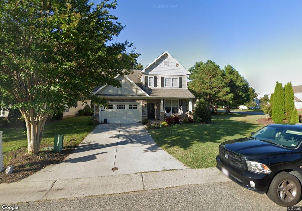
22383 Charthouse Ln Carrollton, VA 23314
Estimated Value: $401,000 - $471,528
4
Beds
3
Baths
2,400
Sq Ft
$185/Sq Ft
Est. Value
About This Home
This home is located at 22383 Charthouse Ln, Carrollton, VA 23314 and is currently estimated at $444,132, approximately $185 per square foot. 22383 Charthouse Ln is a home located in Isle of Wight County with nearby schools including Carrollton Elementary School, Smithfield Middle School, and Smithfield High School.
Ownership History
Date
Name
Owned For
Owner Type
Purchase Details
Closed on
Oct 5, 2022
Sold by
Brown Jason A and Brown Amy C
Bought by
Tugwell Joseph W and Tugwell Amanda
Current Estimated Value
Home Financials for this Owner
Home Financials are based on the most recent Mortgage that was taken out on this home.
Original Mortgage
$407,483
Outstanding Balance
$390,546
Interest Rate
5.66%
Mortgage Type
FHA
Estimated Equity
$53,586
Purchase Details
Closed on
Aug 27, 2010
Sold by
Tract 7 Llc
Purchase Details
Closed on
May 20, 2005
Create a Home Valuation Report for This Property
The Home Valuation Report is an in-depth analysis detailing your home's value as well as a comparison with similar homes in the area
Home Values in the Area
Average Home Value in this Area
Purchase History
| Date | Buyer | Sale Price | Title Company |
|---|---|---|---|
| Tugwell Joseph W | $415,000 | Fidelity National Title | |
| -- | $359,200 | -- | |
| -- | $2,001,000 | -- |
Source: Public Records
Mortgage History
| Date | Status | Borrower | Loan Amount |
|---|---|---|---|
| Open | Tugwell Joseph W | $407,483 |
Source: Public Records
Tax History Compared to Growth
Tax History
| Year | Tax Paid | Tax Assessment Tax Assessment Total Assessment is a certain percentage of the fair market value that is determined by local assessors to be the total taxable value of land and additions on the property. | Land | Improvement |
|---|---|---|---|---|
| 2025 | $3,181 | $410,400 | $70,000 | $340,400 |
| 2024 | $2,996 | $410,400 | $70,000 | $340,400 |
| 2023 | $2,968 | $410,400 | $70,000 | $340,400 |
| 2022 | $2,760 | $318,400 | $70,000 | $248,400 |
| 2021 | $2,760 | $318,400 | $70,000 | $248,400 |
| 2020 | $2,760 | $318,400 | $70,000 | $248,400 |
| 2019 | $2,760 | $318,400 | $70,000 | $248,400 |
| 2018 | $2,607 | $300,300 | $70,000 | $230,300 |
| 2016 | $2,625 | $300,300 | $70,000 | $230,300 |
| 2015 | $2,290 | $300,300 | $70,000 | $230,300 |
| 2014 | $2,290 | $260,900 | $70,000 | $190,900 |
| 2013 | -- | $260,900 | $70,000 | $190,900 |
Source: Public Records
Map
Nearby Homes
- 22346 Tradewinds Dr
- 3.42AC Smiths Neck Rd
- 13032 Lighthouse Ln
- 1105 Rivers Arch
- 1509 Broad Water Arch
- 1002 Rivers Arch
- 902 Rivers Arch
- 301 Blue Heron Trail
- 13435 Prince Andrew Trail
- 410 Marsh Hawk Trail
- 12464 Grand Square Ln
- 13309 Regent Park Walk
- 13436 Prince Andrew Trail
- 13461 Prince Andrew Trail
- Caroline Plan at South Harbor - Towns 55 Plus
- 2002 James River Trail
- 13554 S Village Way
- 13447 Bentley Heath Way
- 13418 Bentley Heath Way Unit 97
- Palladio 2 Story Plan at South Harbor - Single-Family 55 Plus
- 22371 Charthouse Ln
- 22377 Charthouse Ln
- 22382 Charthouse Ln
- 22374 Charthouse Ln
- 13161 Harbor Dr
- 13140 E Bay Ct
- 22365 Charthouse Ln
- 13169 Harbor Dr
- 13134 E Bay Ct
- 22359 Charthouse Ln
- 22400 Harbor Towne Dr
- 13126 E Bay Ct
- 13152 Harbor Dr
- 13160 Harbor Dr
- 22353 Charthouse Ln
- 13177 Harbor Dr Unit RENT
- 13177 Harbor Dr
- 13141 E Bay Ct
- 13168 Harbor Dr
- 13135 E Bay Ct