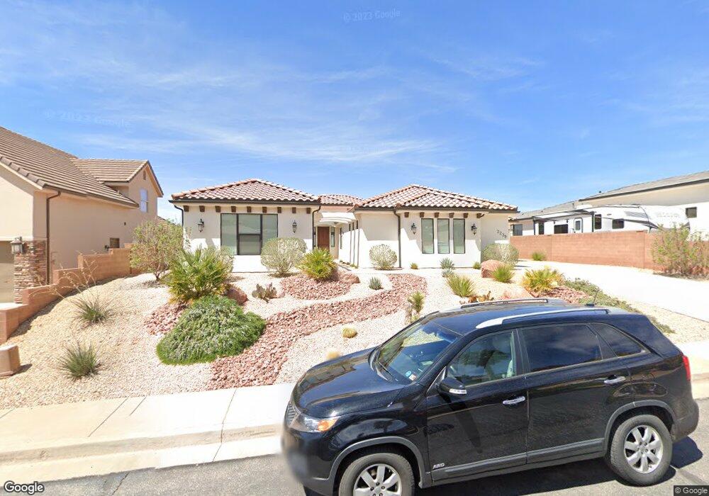
2239 N Gunsight Dr St. George, UT 84770
Estimated Value: $742,000 - $872,000
3
Beds
4
Baths
2,587
Sq Ft
$301/Sq Ft
Est. Value
About This Home
This home is located at 2239 N Gunsight Dr, St. George, UT 84770 and is currently estimated at $779,666, approximately $301 per square foot. 2239 N Gunsight Dr is a home located in Washington County with nearby schools including Snow Canyon Middle School, Diamond Valley School, and Lava Ridge Intermediate School.
Ownership History
Date
Name
Owned For
Owner Type
Purchase Details
Closed on
Sep 14, 2021
Sold by
Andrew Bruce Mcgiven
Bought by
Andrew Bruce Mcgiven and Andrew Margaret Robbins
Current Estimated Value
Home Financials for this Owner
Home Financials are based on the most recent Mortgage that was taken out on this home.
Original Mortgage
$310,000
Outstanding Balance
$281,656
Interest Rate
2.7%
Mortgage Type
New Conventional
Estimated Equity
$498,010
Purchase Details
Closed on
Oct 18, 2019
Sold by
Andrew Bruce Mcgiven
Bought by
Andrew Bruce Mcgiven and Andrew Margaret Robbins
Purchase Details
Closed on
Jan 7, 2019
Sold by
Kaler Daniel L and Kaler Kathy
Bought by
Andrew Bruce Mcgiven
Home Financials for this Owner
Home Financials are based on the most recent Mortgage that was taken out on this home.
Original Mortgage
$447,100
Interest Rate
4.8%
Mortgage Type
New Conventional
Purchase Details
Closed on
Jun 10, 2013
Sold by
Igert Jeremy J and Igert Caren G
Bought by
Kaler Daniel L and Kaler Kathy
Create a Home Valuation Report for This Property
The Home Valuation Report is an in-depth analysis detailing your home's value as well as a comparison with similar homes in the area
Home Values in the Area
Average Home Value in this Area
Purchase History
| Date | Buyer | Sale Price | Title Company |
|---|---|---|---|
| Andrew Bruce Mcgiven | -- | Eagle Gate Ttl Ins Agcy Inc | |
| Andrew Bruce Mcgiven | -- | Eagle Gate Ttl Ins Agcy Inc | |
| Andrew Bruce Mcgiven | -- | Eagle Gate Ttl Ins Agcy Inc | |
| Andrew Bruce Mcgiven | -- | Eagle Gate Title Ins Agency | |
| Kaler Daniel L | -- | Southern Utah Title |
Source: Public Records
Mortgage History
| Date | Status | Borrower | Loan Amount |
|---|---|---|---|
| Open | Andrew Bruce Mcgiven | $310,000 | |
| Closed | Andrew Bruce Mcgiven | $447,100 |
Source: Public Records
Tax History Compared to Growth
Tax History
| Year | Tax Paid | Tax Assessment Tax Assessment Total Assessment is a certain percentage of the fair market value that is determined by local assessors to be the total taxable value of land and additions on the property. | Land | Improvement |
|---|---|---|---|---|
| 2025 | $2,745 | $413,105 | $130,900 | $282,205 |
| 2023 | $2,605 | $389,180 | $123,200 | $265,980 |
| 2022 | $2,851 | $400,565 | $115,500 | $285,065 |
| 2021 | $2,717 | $569,400 | $175,000 | $394,400 |
| 2020 | $2,664 | $525,700 | $140,000 | $385,700 |
| 2019 | $1,320 | $140,000 | $140,000 | $0 |
| 2018 | $1,055 | $105,000 | $0 | $0 |
| 2017 | $1,086 | $105,000 | $0 | $0 |
| 2016 | $1,175 | $105,000 | $0 | $0 |
| 2015 | $1,224 | $105,000 | $0 | $0 |
| 2014 | $1,217 | $105,000 | $0 | $0 |
Source: Public Records
Map
Nearby Homes
- 2294 N Gunsight Dr
- 2090 N Tuweap Dr Unit 13
- 2090 N Tuweap Dr Unit 9
- 2090 N Tuweap Dr Unit 15
- 2090 N Tuweap Dr Unit 56
- 2139 W Cougar Rock Cir
- 2139 W Cougar Rock Cir Unit 131
- 2139 W Cougar Rock Cir Unit 179
- 2139 W Cougar Rock Cir Unit 135
- 2139 W Cougar Rock Cir Unit 195
- 2139 W Cougar Rock Cir Unit 182
- 1996 W 1940 N
- 20 Grayhawk Cir
- 2047 W Cougar Rock Cir
- 1959 W Cougar Rock Cir
- 1995 W 1900 N
- 2255 N Tuweap Dr Unit 14
- 2255 N Tuweap Dr Unit 58
- 2255 N Tuweap Dr Unit 54
- 2251 N Gunsight Dr
- 2225 N Gunsight Dr
- 2213 N Gunsight Dr
- 2263 N Gunsight Dr
- 2242 N Gunsight Dr
- 2228 N Gunsight Dr
- 2254 N Gunsight Dr
- 1838 W Ticaboo
- 2197 N Gunsight Dr
- 2277 N Gunsight Dr
- 2266 N Gunsight Dr
- 2245 N Cascade Canyon Dr
- 2280 N Gunsight Dr
- 2259 N Cascade Canyon Dr
- 2185 N Gunsight Dr
- 2259 N Cascade Dr
- 2289 N Gunsight Dr
- 1835 W Ticaboo
- 2271 N Cascade Canyon Dr
- 2203 Lone Rock Dr