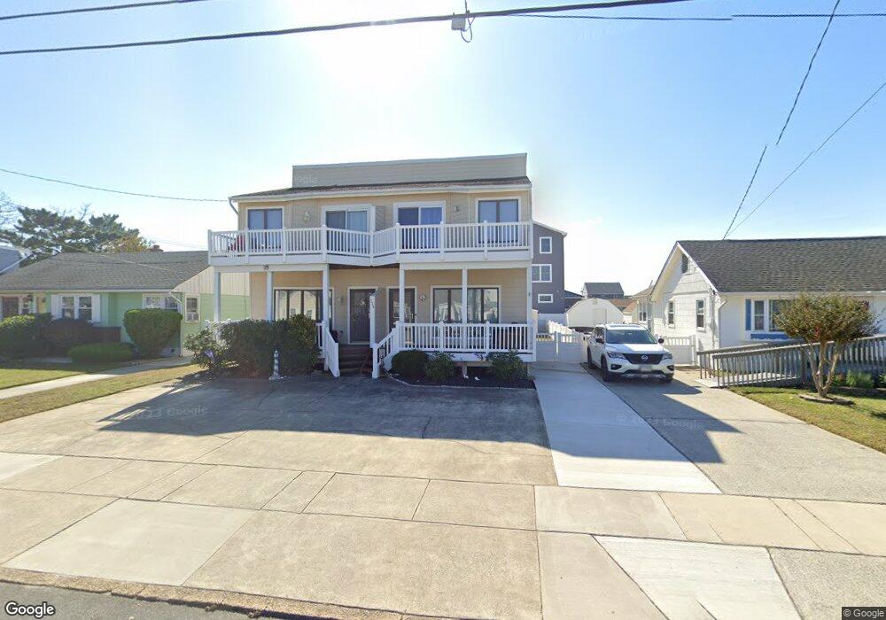
224 7th St S Unit A Brigantine, NJ 08203
Estimated Value: $473,330 - $840,000
--
Bed
--
Bath
1,312
Sq Ft
$498/Sq Ft
Est. Value
About This Home
This home is located at 224 7th St S Unit A, Brigantine, NJ 08203 and is currently estimated at $653,583, approximately $498 per square foot. 224 7th St S Unit A is a home located in Atlantic County with nearby schools including Brigantine Elementary School and Brigantine Community School.
Ownership History
Date
Name
Owned For
Owner Type
Purchase Details
Closed on
Apr 26, 2002
Sold by
Landay James W and Landay Barbara
Bought by
Martillotti Joseph G and Martillotti Luciana
Current Estimated Value
Home Financials for this Owner
Home Financials are based on the most recent Mortgage that was taken out on this home.
Original Mortgage
$150,000
Interest Rate
6.63%
Purchase Details
Closed on
Jan 10, 1998
Sold by
Toncar Jan H and Toncar Rosemary L
Bought by
Landay James W and Landay Barbara
Home Financials for this Owner
Home Financials are based on the most recent Mortgage that was taken out on this home.
Original Mortgage
$88,000
Interest Rate
6.59%
Create a Home Valuation Report for This Property
The Home Valuation Report is an in-depth analysis detailing your home's value as well as a comparison with similar homes in the area
Home Values in the Area
Average Home Value in this Area
Purchase History
Date | Buyer | Sale Price | Title Company |
---|---|---|---|
Martillotti Joseph G | $225,000 | Commonwealth Land Title | |
Landay James W | $110,000 | The Title Company |
Source: Public Records
Mortgage History
Date | Status | Borrower | Loan Amount |
---|---|---|---|
Closed | Martillotti Joseph G | $150,000 | |
Previous Owner | Landay James W | $88,000 |
Source: Public Records
Tax History Compared to Growth
Tax History
Year | Tax Paid | Tax Assessment Tax Assessment Total Assessment is a certain percentage of the fair market value that is determined by local assessors to be the total taxable value of land and additions on the property. | Land | Improvement |
---|---|---|---|---|
2024 | $4,561 | $242,600 | $161,000 | $81,600 |
2023 | $4,214 | $242,600 | $161,000 | $81,600 |
2022 | $4,214 | $242,600 | $161,000 | $81,600 |
2021 | $4,139 | $242,600 | $161,000 | $81,600 |
2020 | $4,095 | $242,600 | $161,000 | $81,600 |
2019 | $4,131 | $242,600 | $161,000 | $81,600 |
2018 | $4,214 | $242,600 | $161,000 | $81,600 |
2017 | $4,282 | $242,600 | $161,000 | $81,600 |
2016 | $4,279 | $242,600 | $161,000 | $81,600 |
2015 | $4,301 | $242,600 | $161,000 | $81,600 |
2014 | $4,141 | $242,600 | $161,000 | $81,600 |
Source: Public Records
Map
Nearby Homes
- 222 8th St S
- 155 Sheridan Square Unit A
- 150 9th St S
- 800 W Brigantine Ave Unit 209
- 900 W Brigantine Ave
- 135 11th St S
- 321 6th St S Unit 15
- 321 6th St S Unit 3
- 321 6th St S Unit 16
- 321 6th St S Unit 2
- 321 6th St S Unit 12
- 321 6th St S Unit 1
- 321 6th Unit 14 St Unit 14
- 250 11th St S
- 115 4th St S
- 1018 Bayshore Ave
- 400 W Brigantine Ave Unit 2
- 305 Beach Ave W Unit A and B
- 300 W Brigantine Ave Unit 102
- 212 W Brigantine Ave Unit 305