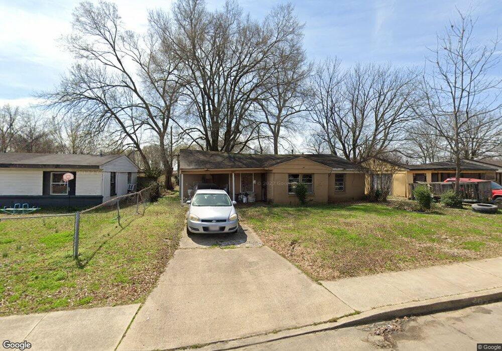
224 Bettis St West Memphis, AR 72301
Estimated Value: $72,000 - $101,000
--
Bed
1
Bath
996
Sq Ft
$93/Sq Ft
Est. Value
About This Home
This home is located at 224 Bettis St, West Memphis, AR 72301 and is currently estimated at $92,436, approximately $92 per square foot. 224 Bettis St is a home located in Crittenden County with nearby schools including Maddux Elementary School, Wonder Junior High School, and The Academies of West Memphis Charter School.
Ownership History
Date
Name
Owned For
Owner Type
Purchase Details
Closed on
Feb 12, 2016
Sold by
Us Bank Na
Bought by
Miller Joyce
Current Estimated Value
Purchase Details
Closed on
Jul 8, 2013
Sold by
Cole Alan H
Bought by
Lamar Angela
Purchase Details
Closed on
Dec 9, 2005
Sold by
Johnson Billie
Bought by
Cole Alan
Purchase Details
Closed on
Oct 6, 2005
Sold by
Hale'S Rental Llc
Bought by
Hale William Merritt
Purchase Details
Closed on
Aug 7, 1993
Sold by
Not Provided
Bought by
Cole Alan
Purchase Details
Closed on
Dec 1, 1989
Bought by
To
Purchase Details
Closed on
Jul 1, 1989
Bought by
To
Create a Home Valuation Report for This Property
The Home Valuation Report is an in-depth analysis detailing your home's value as well as a comparison with similar homes in the area
Home Values in the Area
Average Home Value in this Area
Purchase History
| Date | Buyer | Sale Price | Title Company |
|---|---|---|---|
| Miller Joyce | $4,000 | None Available | |
| Lamar Angela | $1,000 | -- | |
| Cole Alan | -- | -- | |
| Hale William Merritt | -- | -- | |
| Cole Alan | $12,000 | -- | |
| To | $25,000 | -- | |
| To | -- | -- |
Source: Public Records
Tax History Compared to Growth
Tax History
| Year | Tax Paid | Tax Assessment Tax Assessment Total Assessment is a certain percentage of the fair market value that is determined by local assessors to be the total taxable value of land and additions on the property. | Land | Improvement |
|---|---|---|---|---|
| 2024 | $65 | $1,260 | $800 | $460 |
| 2023 | $65 | $1,260 | $800 | $460 |
| 2022 | $65 | $1,260 | $800 | $460 |
| 2021 | $65 | $1,260 | $800 | $460 |
| 2020 | $57 | $1,260 | $800 | $460 |
| 2019 | $105 | $2,060 | $1,600 | $460 |
| 2018 | $244 | $5,880 | $1,600 | $4,280 |
| 2017 | $244 | $5,880 | $1,600 | $4,280 |
| 2016 | $225 | $5,880 | $1,600 | $4,280 |
| 2015 | $22 | $5,880 | $1,600 | $4,280 |
| 2014 | $26 | $7,560 | $1,600 | $5,960 |
Source: Public Records
Map
Nearby Homes
- 156 Stuart Ave
- 2501 Gathings Dr
- 516 N 28th St
- 2404 N Woodlawn Dr
- 403 N Ok St
- 2706 Tyler Ave
- 316 Magnolia St
- 201 S 31st St
- 306 N 35th St
- 334 S 21st St
- 1804 Scottwood St
- 538 N 18th St
- 721 N Mcauley Dr
- 2604 E Jackson Ave
- 725 Sula Ln
- 2609 E Jackson Ave
- 803 N 18th St
- 2804 E Tyler Ave
- 1603 Scottwood St
- 519 N 14th St